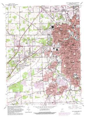
Fort Wayne West Topo Map Indiana
To zoom in, hover over the map of Fort Wayne West
USGS Topo Quad 41085a2 - 1:24,000 scale
| Topo Map Name: | Fort Wayne West |
| USGS Topo Quad ID: | 41085a2 |
| Print Size: | ca. 21 1/4" wide x 27" high |
| Southeast Coordinates: | 41° N latitude / 85.125° W longitude |
| Map Center Coordinates: | 41.0625° N latitude / 85.1875° W longitude |
| U.S. State: | IN |
| Filename: | o41085a2.jpg |
| Download Map JPG Image: | Fort Wayne West topo map 1:24,000 scale |
| Map Type: | Topographic |
| Topo Series: | 7.5´ |
| Map Scale: | 1:24,000 |
| Source of Map Images: | United States Geological Survey (USGS) |
| Alternate Map Versions: |
Fort Wayne West IN 1956, updated 1958 Download PDF Buy paper map Fort Wayne West IN 1963, updated 1965 Download PDF Buy paper map Fort Wayne West IN 1963, updated 1974 Download PDF Buy paper map Fort Wayne West IN 1963, updated 1982 Download PDF Buy paper map Fort Wayne West IN 1963, updated 1982 Download PDF Buy paper map Fort Wayne West IN 1998, updated 2001 Download PDF Buy paper map Fort Wayne West IN 2010 Download PDF Buy paper map Fort Wayne West IN 2013 Download PDF Buy paper map Fort Wayne West IN 2016 Download PDF Buy paper map |
1:24,000 Topo Quads surrounding Fort Wayne West
> Back to 41085a1 at 1:100,000 scale
> Back to 41084a1 at 1:250,000 scale
> Back to U.S. Topo Maps home
Fort Wayne West topo map: Gazetteer
Fort Wayne West: Airports
Kellys Patch Airport elevation 256m 839′Fort Wayne West: Bridges
Stellhorn Bridge elevation 227m 744′Fort Wayne West: Canals
Durnell Ditch elevation 246m 807′Fairfield Ditch elevation 229m 751′
Flaugh Ditch elevation 242m 793′
Graham McCulloch Ditch elevation 230m 754′
Junk Ditch elevation 228m 748′
Lowther Neuhaus Ditch elevation 238m 780′
Seegar Ditch elevation 256m 839′
Fort Wayne West: Crossings
Interchange 105 elevation 250m 820′Interchange 109 elevation 256m 839′
Fort Wayne West: Islands
Stevies Island elevation 229m 751′Stevies Island elevation 229m 751′
Fort Wayne West: Lakes
Mirror Lake elevation 240m 787′Fort Wayne West: Parks
Foster Park elevation 231m 757′Franke Park elevation 244m 800′
Greenlawn Memorial Park elevation 249m 816′
Hamilton Park elevation 235m 770′
Hanna Park elevation 241m 790′
Kettler Park elevation 240m 787′
Lafayette Park elevation 248m 813′
Lawton Park elevation 230m 754′
McCulloch Park elevation 235m 770′
Packard Park elevation 243m 797′
Psi Ote Park elevation 240m 787′
Reservoir Park elevation 246m 807′
Rockhill Park elevation 232m 761′
Sherman Park elevation 230m 754′
Swinney Park elevation 230m 754′
Vesey Park elevation 233m 764′
Waynedale Memorial Park elevation 238m 780′
Weisser Park elevation 244m 800′
Williams Park elevation 244m 800′
Fort Wayne West: Populated Places
Ansley Acres elevation 250m 820′Avalon elevation 239m 784′
Brierwood Hills elevation 242m 793′
Country Club Gardens elevation 237m 777′
Covington Dells elevation 242m 793′
Hillcrest elevation 236m 774′
Indian Village elevation 235m 770′
Lake Shores elevation 236m 774′
Lincolnshire elevation 236m 774′
North Highland elevation 242m 793′
Northcrest elevation 240m 787′
Times Corner elevation 244m 800′
Waynedale elevation 237m 777′
Westchester elevation 242m 793′
Westlawn elevation 256m 839′
Westmoor elevation 243m 797′
Fort Wayne West: Reservoirs
Shoaff Lake elevation 235m 770′Fort Wayne West: Streams
Saint Marys River elevation 229m 751′Spy Run Creek elevation 228m 748′
Willowdale Creek elevation 228m 748′
Fort Wayne West digital topo map on disk
Buy this Fort Wayne West topo map showing relief, roads, GPS coordinates and other geographical features, as a high-resolution digital map file on DVD:
Northern Illinois, Northern Indiana & Southwestern Michigan
Buy digital topo maps: Northern Illinois, Northern Indiana & Southwestern Michigan


