Auburn Topo Map Indiana
To zoom in, hover over the map of Auburn
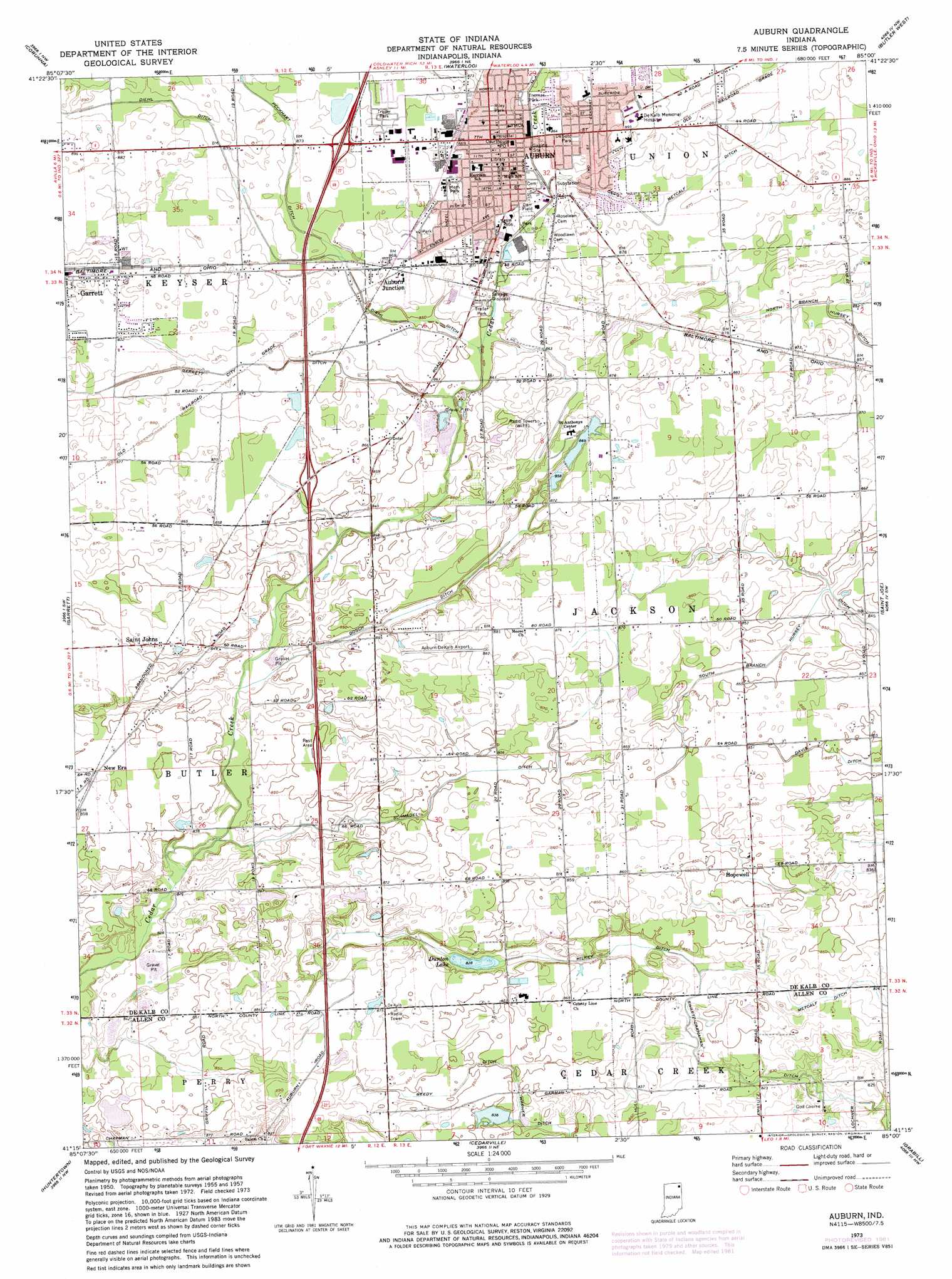
USGS Topo Quad 41085c1 - 1:24,000 scale
| Topo Map Name: | Auburn |
| USGS Topo Quad ID: | 41085c1 |
| Print Size: | ca. 21 1/4" wide x 27" high |
| Southeast Coordinates: | 41.25° N latitude / 85° W longitude |
| Map Center Coordinates: | 41.3125° N latitude / 85.0625° W longitude |
| U.S. State: | IN |
| Filename: | o41085c1.jpg |
| Download Map JPG Image: | Auburn topo map 1:24,000 scale |
| Map Type: | Topographic |
| Topo Series: | 7.5´ |
| Map Scale: | 1:24,000 |
| Source of Map Images: | United States Geological Survey (USGS) |
| Alternate Map Versions: |
Auburn IN 1957, updated 1959 Download PDF Buy paper map Auburn IN 1973, updated 1975 Download PDF Buy paper map Auburn IN 1973, updated 1981 Download PDF Buy paper map Auburn IN 2010 Download PDF Buy paper map Auburn IN 2013 Download PDF Buy paper map Auburn IN 2016 Download PDF Buy paper map |
1:24,000 Topo Quads surrounding Auburn
Wolcottville |
Stroh |
Ashley |
Hamilton |
Edon |
Kendallville |
Corunna |
Waterloo |
Butler West |
Butler East |
Ege |
Garrett |
Auburn |
Saint Joe |
Hicksville |
Churubusco |
Huntertown |
Cedarville |
Grabill |
Woodburn North |
Arcola |
Fort Wayne West |
Fort Wayne East |
Maples |
Woodburn South |
> Back to 41085a1 at 1:100,000 scale
> Back to 41084a1 at 1:250,000 scale
> Back to U.S. Topo Maps home
Auburn topo map: Gazetteer
Auburn: Airports
Auburn Dekalb Airport elevation 269m 882′Auburn: Canals
Beedy Ditch elevation 256m 839′Cecil Metcalf Ditch elevation 263m 862′
Dosch Ditch elevation 254m 833′
Garrett Ditch elevation 260m 853′
Halkey Ditch elevation 251m 823′
John Diehl Ditch elevation 256m 839′
Schmadel Ditch elevation 256m 839′
Swartz-Carnahan Ditch elevation 246m 807′
Auburn: Dams
Beedy Lake Dam elevation 258m 846′Saint Anthonys Center Lake Dam elevation 268m 879′
Auburn: Lakes
Dunton Lake elevation 252m 826′Auburn: Parks
Carr Field elevation 261m 856′Desoto Park elevation 264m 866′
Memorial Park elevation 265m 869′
Riley Park elevation 264m 866′
Thomas Park elevation 261m 856′
Auburn: Populated Places
Auburn elevation 264m 866′Auburn Junction elevation 264m 866′
Hopewell elevation 259m 849′
New Era elevation 262m 859′
Saint Johns elevation 262m 859′
Auburn: Reservoirs
Beedy Lake elevation 258m 846′Saint Anthonys Center Lake elevation 268m 879′
Auburn digital topo map on disk
Buy this Auburn topo map showing relief, roads, GPS coordinates and other geographical features, as a high-resolution digital map file on DVD:
Northern Illinois, Northern Indiana & Southwestern Michigan
Buy digital topo maps: Northern Illinois, Northern Indiana & Southwestern Michigan