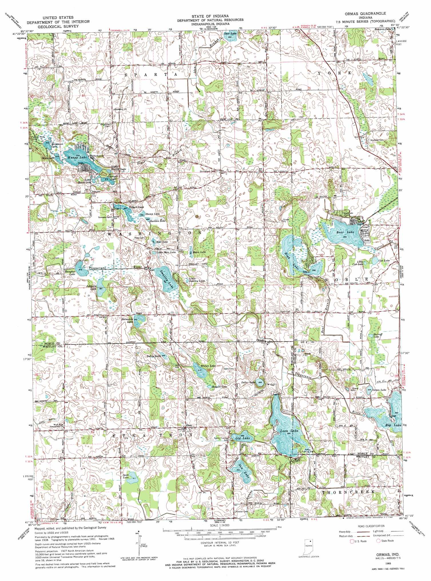
Ormas Topo Map Indiana
To zoom in, hover over the map of Ormas
USGS Topo Quad 41085c5 - 1:24,000 scale
| Topo Map Name: | Ormas |
| USGS Topo Quad ID: | 41085c5 |
| Print Size: | ca. 21 1/4" wide x 27" high |
| Southeast Coordinates: | 41.25° N latitude / 85.5° W longitude |
| Map Center Coordinates: | 41.3125° N latitude / 85.5625° W longitude |
| U.S. State: | IN |
| Filename: | o41085c5.jpg |
| Download Map JPG Image: | Ormas topo map 1:24,000 scale |
| Map Type: | Topographic |
| Topo Series: | 7.5´ |
| Map Scale: | 1:24,000 |
| Source of Map Images: | United States Geological Survey (USGS) |
| Alternate Map Versions: |
Ormas IN 1951, updated 1952 Download PDF Buy paper map Ormas IN 1965, updated 1967 Download PDF Buy paper map Ormas IN 2010 Download PDF Buy paper map Ormas IN 2013 Download PDF Buy paper map Ormas IN 2016 Download PDF Buy paper map |
1:24,000 Topo Quads surrounding Ormas
Goshen |
Millersburg |
Topeka |
Oliver Lake |
Wolcottville |
Milford |
Lake Wawasee |
Ligonier |
Albion |
Kendallville |
Leesburg |
North Webster |
Ormas |
Merriam |
Ege |
Warsaw |
Pierceton |
Lorane |
Columbia City |
Churubusco |
North Manchester North |
South Whitley West |
South Whitley East |
Laud |
Arcola |
> Back to 41085a1 at 1:100,000 scale
> Back to 41084a1 at 1:250,000 scale
> Back to U.S. Topo Maps home
Ormas topo map: Gazetteer
Ormas: Canals
Friskney Ditch elevation 276m 905′Gaff Ditch elevation 281m 921′
Smith Ditch elevation 268m 879′
Winters Ditch elevation 274m 898′
Ormas: Lakes
Baugher Lake elevation 269m 882′Bear Lake elevation 273m 895′
Beers Lake elevation 275m 902′
Buckles Lake elevation 271m 889′
Cub Lake elevation 272m 892′
Gilbert Lake elevation 271m 889′
Green Lake elevation 274m 898′
Harper Lake elevation 267m 875′
High Lake elevation 274m 898′
Hindman Lake elevation 267m 875′
Horseshoe Lake elevation 275m 902′
Johnson Lake elevation 269m 882′
Knapp Lake elevation 267m 875′
Little Bause Lake elevation 266m 872′
Little Knapp Lake elevation 267m 875′
Little Metz Lake elevation 271m 889′
Loon Lake elevation 273m 895′
Metz Lake elevation 271m 889′
Moss Lake elevation 267m 875′
New Lake elevation 274m 898′
Old Lake elevation 274m 898′
Scott Lake elevation 278m 912′
Smalley Lake elevation 270m 885′
Stump Lake elevation 271m 889′
Ormas: Parks
Pioneer Trails Camp (historical) elevation 272m 892′Ormas: Populated Places
Etna elevation 284m 931′Ormas elevation 276m 905′
Washington Center elevation 282m 925′
Ormas: Reservoirs
Bennett Lake elevation 280m 918′Brown Lake elevation 280m 918′
Dollar Lake elevation 275m 902′
Harroff Lake elevation 275m 902′
Indian Lake elevation 276m 905′
Little Cub Lake elevation 273m 895′
Little Smalley Lake elevation 270m 885′
Ormas: Streams
Beal Branch elevation 273m 895′Carrol Creek elevation 273m 895′
Iden Branch elevation 272m 892′
Piper Branch elevation 268m 879′
Ormas digital topo map on disk
Buy this Ormas topo map showing relief, roads, GPS coordinates and other geographical features, as a high-resolution digital map file on DVD:
Northern Illinois, Northern Indiana & Southwestern Michigan
Buy digital topo maps: Northern Illinois, Northern Indiana & Southwestern Michigan