Corunna Topo Map Indiana
To zoom in, hover over the map of Corunna
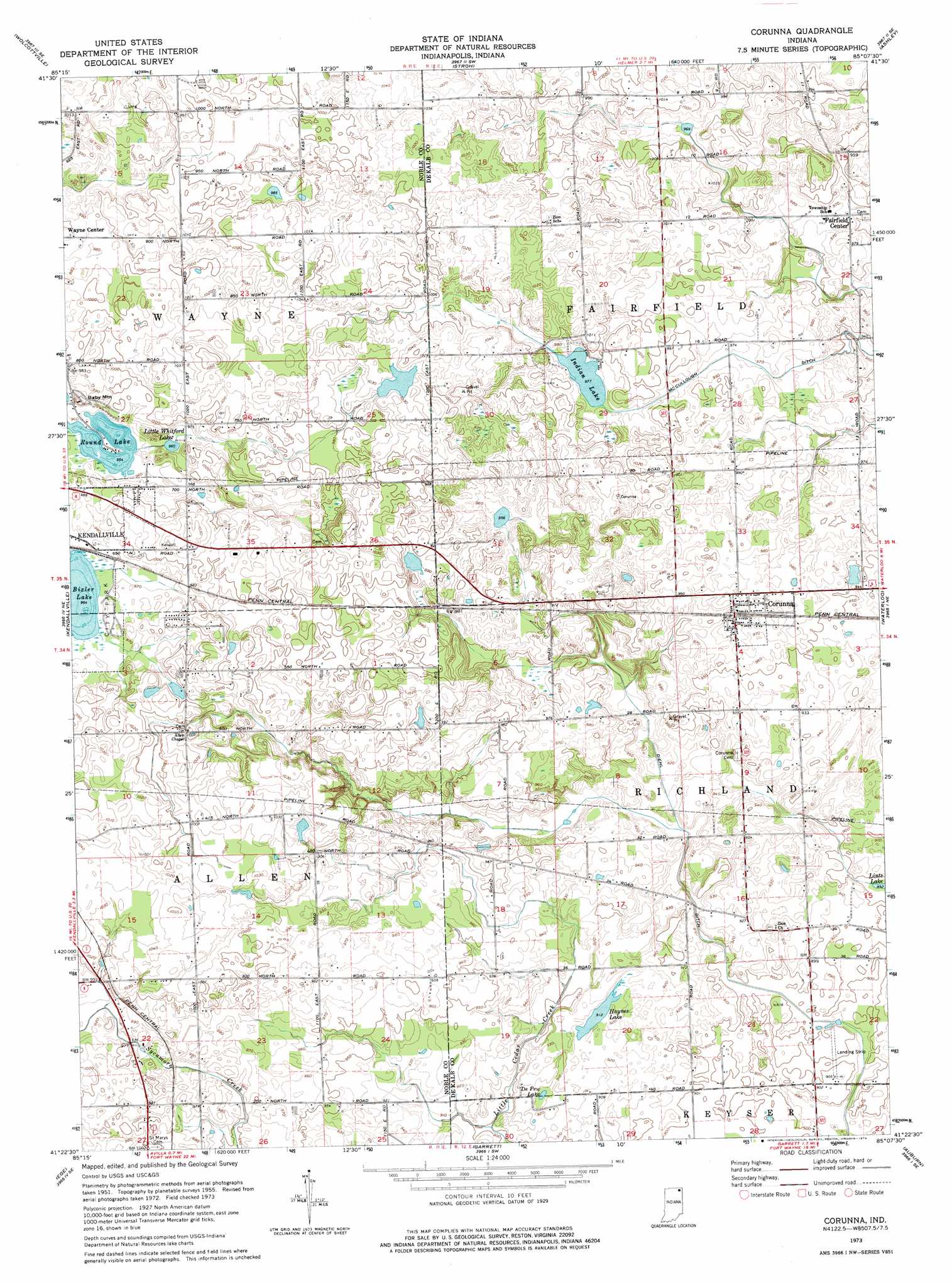
USGS Topo Quad 41085d2 - 1:24,000 scale
| Topo Map Name: | Corunna |
| USGS Topo Quad ID: | 41085d2 |
| Print Size: | ca. 21 1/4" wide x 27" high |
| Southeast Coordinates: | 41.375° N latitude / 85.125° W longitude |
| Map Center Coordinates: | 41.4375° N latitude / 85.1875° W longitude |
| U.S. State: | IN |
| Filename: | o41085d2.jpg |
| Download Map JPG Image: | Corunna topo map 1:24,000 scale |
| Map Type: | Topographic |
| Topo Series: | 7.5´ |
| Map Scale: | 1:24,000 |
| Source of Map Images: | United States Geological Survey (USGS) |
| Alternate Map Versions: |
Corunna IN 1955, updated 1957 Download PDF Buy paper map Corunna IN 1973, updated 1974 Download PDF Buy paper map Corunna IN 2010 Download PDF Buy paper map Corunna IN 2013 Download PDF Buy paper map Corunna IN 2016 Download PDF Buy paper map |
1:24,000 Topo Quads surrounding Corunna
Lagrange |
Mongo |
Orland |
Angola West |
Angola East |
Oliver Lake |
Wolcottville |
Stroh |
Ashley |
Hamilton |
Albion |
Kendallville |
Corunna |
Waterloo |
Butler West |
Merriam |
Ege |
Garrett |
Auburn |
Saint Joe |
Columbia City |
Churubusco |
Huntertown |
Cedarville |
Grabill |
> Back to 41085a1 at 1:100,000 scale
> Back to 41084a1 at 1:250,000 scale
> Back to U.S. Topo Maps home
Corunna topo map: Gazetteer
Corunna: Canals
Diehl Ditch elevation 270m 885′McCullough Ditch elevation 294m 964′
Corunna: Dams
Niezer Dam elevation 314m 1030′Corunna: Lakes
Bixler Lake elevation 294m 964′Depew Lake elevation 277m 908′
Haynes Lake elevation 280m 918′
Indian Lake elevation 298m 977′
Little Whitford Lake elevation 292m 958′
Round Lake elevation 291m 954′
Corunna: Populated Places
Corunna elevation 297m 974′Fairfield Center elevation 294m 964′
Corunna: Reservoirs
Lake Maxler elevation 314m 1030′Corunna: Summits
Baby Mountain elevation 310m 1017′Corunna digital topo map on disk
Buy this Corunna topo map showing relief, roads, GPS coordinates and other geographical features, as a high-resolution digital map file on DVD:
Northern Illinois, Northern Indiana & Southwestern Michigan
Buy digital topo maps: Northern Illinois, Northern Indiana & Southwestern Michigan