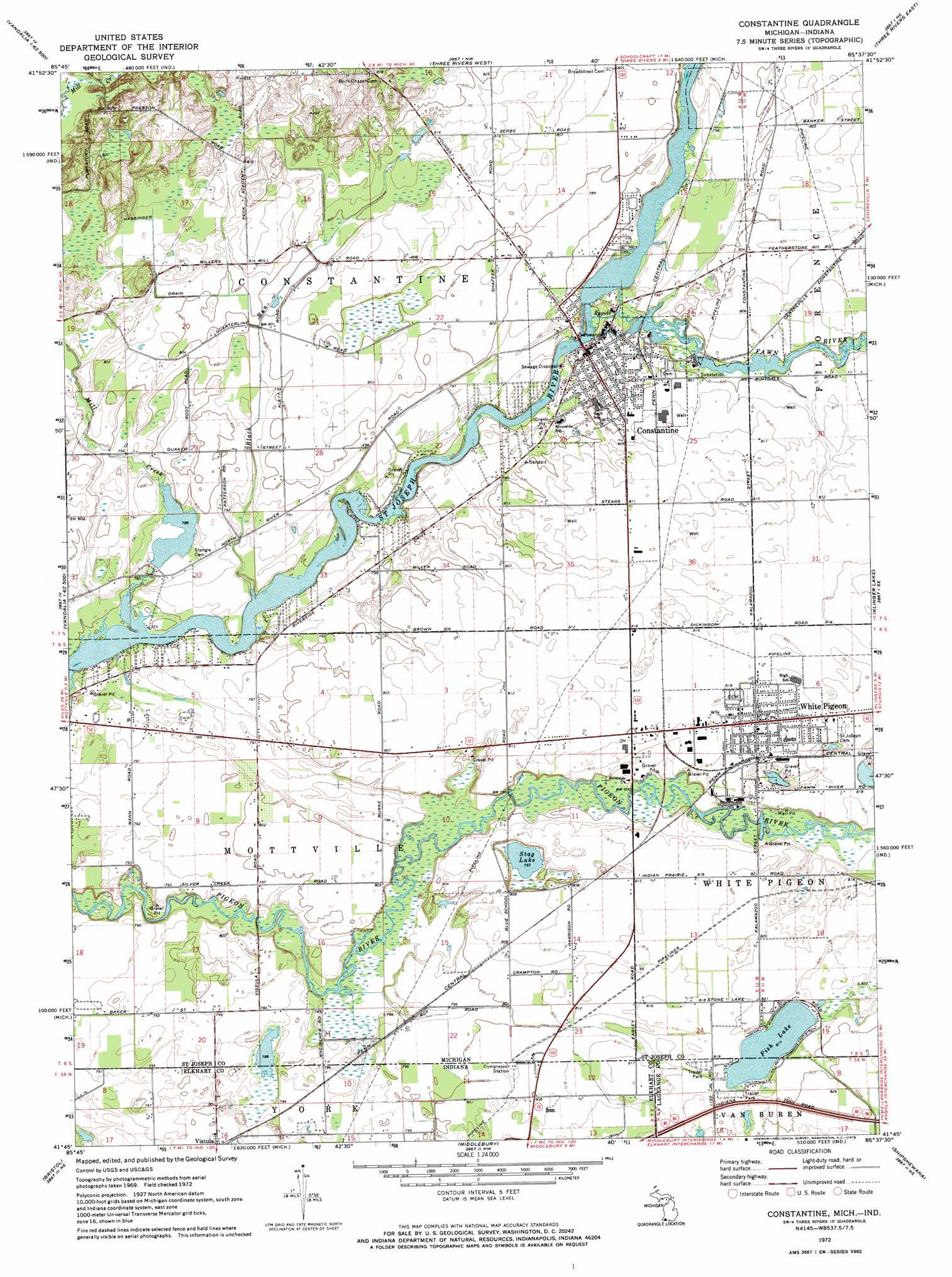
Constantine Topo Map Michigan
To zoom in, hover over the map of Constantine
USGS Topo Quad 41085g6 - 1:24,000 scale
| Topo Map Name: | Constantine |
| USGS Topo Quad ID: | 41085g6 |
| Print Size: | ca. 21 1/4" wide x 27" high |
| Southeast Coordinates: | 41.75° N latitude / 85.625° W longitude |
| Map Center Coordinates: | 41.8125° N latitude / 85.6875° W longitude |
| U.S. States: | MI, IN |
| Filename: | o41085g6.jpg |
| Download Map JPG Image: | Constantine topo map 1:24,000 scale |
| Map Type: | Topographic |
| Topo Series: | 7.5´ |
| Map Scale: | 1:24,000 |
| Source of Map Images: | United States Geological Survey (USGS) |
| Alternate Map Versions: |
Constantine MI 1972, updated 1974 Download PDF Buy paper map Constantine MI 2011 Download PDF Buy paper map Constantine MI 2014 Download PDF Buy paper map Constantine MI 2016 Download PDF Buy paper map |
1:24,000 Topo Quads surrounding Constantine
Decatur |
Marcellus |
Schoolcraft |
Vicksburg |
Mendon |
Vandalia |
Jones |
Three Rivers West |
Three Rivers East |
Nottawa |
Adamsville |
Mottville |
Constantine |
Klinger Lake |
Sturgis |
Elkhart |
Bristol |
Middlebury |
Shipshewana |
Lagrange |
Foraker |
Goshen |
Millersburg |
Topeka |
Oliver Lake |
> Back to 41085e1 at 1:100,000 scale
> Back to 41084a1 at 1:250,000 scale
> Back to U.S. Topo Maps home
Constantine topo map: Gazetteer
Constantine: Canals
Hassinger Drain elevation 246m 807′Love Joy Ditch elevation 242m 793′
Constantine: Lakes
Fish Lake elevation 247m 810′Fish Lake elevation 247m 810′
Stag Lake elevation 242m 793′
Constantine: Parks
Chief Wahbememe Burial Site Historical Marker elevation 249m 816′Constantine Riverview Playland elevation 237m 777′
Constantine United Methodist Church Historical Marker elevation 241m 790′
Heywood House Historical Marker elevation 241m 790′
Messiah Evangelical Lutheran Church Historical Marker elevation 241m 790′
Three Rivers State Game Area elevation 266m 872′
United States Land Office Historical Marker elevation 249m 816′
Wade Park elevation 250m 820′
Well Field Baseball Park elevation 247m 810′
Constantine: Populated Places
Colonial Estates Mobile Home Park elevation 249m 816′Constantine elevation 240m 787′
Whipsering Pines Mobile Home Park elevation 245m 803′
Whipsering Pines Mobile Home Park elevation 245m 803′
White Pigeon elevation 249m 816′
Constantine: Post Offices
Constantine Post Office elevation 241m 790′White Pigeon Post Office elevation 249m 816′
Constantine: Streams
Black Run elevation 236m 774′Fawn River elevation 236m 774′
Mill Creek elevation 236m 774′
Constantine digital topo map on disk
Buy this Constantine topo map showing relief, roads, GPS coordinates and other geographical features, as a high-resolution digital map file on DVD:
Northern Illinois, Northern Indiana & Southwestern Michigan
Buy digital topo maps: Northern Illinois, Northern Indiana & Southwestern Michigan