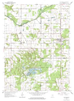
San Pierre Topo Map Indiana
To zoom in, hover over the map of San Pierre
USGS Topo Quad 41086b8 - 1:24,000 scale
| Topo Map Name: | San Pierre |
| USGS Topo Quad ID: | 41086b8 |
| Print Size: | ca. 21 1/4" wide x 27" high |
| Southeast Coordinates: | 41.125° N latitude / 86.875° W longitude |
| Map Center Coordinates: | 41.1875° N latitude / 86.9375° W longitude |
| U.S. State: | IN |
| Filename: | o41086b8.jpg |
| Download Map JPG Image: | San Pierre topo map 1:24,000 scale |
| Map Type: | Topographic |
| Topo Series: | 7.5´ |
| Map Scale: | 1:24,000 |
| Source of Map Images: | United States Geological Survey (USGS) |
| Alternate Map Versions: |
San Pierre IN 1959, updated 1961 Download PDF Buy paper map San Pierre IN 1959, updated 1977 Download PDF Buy paper map San Pierre IN 2010 Download PDF Buy paper map San Pierre IN 2013 Download PDF Buy paper map San Pierre IN 2016 Download PDF Buy paper map |
1:24,000 Topo Quads surrounding San Pierre
> Back to 41086a1 at 1:100,000 scale
> Back to 41086a1 at 1:250,000 scale
> Back to U.S. Topo Maps home
San Pierre topo map: Gazetteer
San Pierre: Canals
Anthony Ditch elevation 214m 702′Armstrong Ditch elevation 211m 692′
Bass Ditch elevation 206m 675′
Elkheim Ditch elevation 202m 662′
Hall Burlew Ditch elevation 213m 698′
Hinshaw Ditch elevation 204m 669′
Joseph Salrin Arm elevation 212m 695′
Luken Ditch elevation 214m 702′
Mylius Ditch elevation 201m 659′
Prochaska Ditch elevation 206m 675′
Rassmussen Ditch elevation 204m 669′
Ryan Kraisinger Ditch elevation 210m 688′
Sands Ditch elevation 203m 666′
Shadrow Ditch elevation 214m 702′
West Arm Scholtz elevation 214m 702′
Zick Ditch elevation 209m 685′
San Pierre: Parks
Jasper-Pulaski Fish and Wildlife Area elevation 215m 705′Jasper-Pulaski Nursery elevation 213m 698′
San Pierre: Populated Places
Clarks elevation 215m 705′Dunns Bridge elevation 202m 662′
Radioville elevation 215m 705′
San Pierre elevation 212m 695′
Tefft elevation 206m 675′
San Pierre digital topo map on disk
Buy this San Pierre topo map showing relief, roads, GPS coordinates and other geographical features, as a high-resolution digital map file on DVD:
Northern Illinois, Northern Indiana & Southwestern Michigan
Buy digital topo maps: Northern Illinois, Northern Indiana & Southwestern Michigan


