Bremen Topo Map Indiana
To zoom in, hover over the map of Bremen
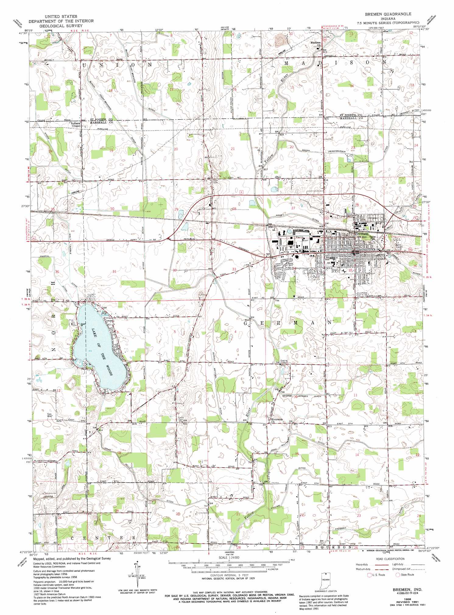
USGS Topo Quad 41086d2 - 1:24,000 scale
| Topo Map Name: | Bremen |
| USGS Topo Quad ID: | 41086d2 |
| Print Size: | ca. 21 1/4" wide x 27" high |
| Southeast Coordinates: | 41.375° N latitude / 86.125° W longitude |
| Map Center Coordinates: | 41.4375° N latitude / 86.1875° W longitude |
| U.S. State: | IN |
| Filename: | o41086d2.jpg |
| Download Map JPG Image: | Bremen topo map 1:24,000 scale |
| Map Type: | Topographic |
| Topo Series: | 7.5´ |
| Map Scale: | 1:24,000 |
| Source of Map Images: | United States Geological Survey (USGS) |
| Alternate Map Versions: |
Bremen IN 1958, updated 1960 Download PDF Buy paper map Bremen IN 1958, updated 1980 Download PDF Buy paper map Bremen IN 1958, updated 1980 Download PDF Buy paper map Bremen IN 1958, updated 1987 Download PDF Buy paper map Bremen IN 1958, updated 1991 Download PDF Buy paper map Bremen IN 2010 Download PDF Buy paper map Bremen IN 2013 Download PDF Buy paper map Bremen IN 2016 Download PDF Buy paper map |
1:24,000 Topo Quads surrounding Bremen
Lydick |
South Bend West |
South Bend East |
Osceola |
Elkhart |
North Liberty |
Lakeville |
Wyatt |
Wakarusa |
Foraker |
Walkerton |
La Paz |
Bremen |
Nappanee West |
Nappanee East |
Donaldson |
Plymouth |
Inwood |
Bourbon |
Atwood |
Culver |
Rutland |
Argos |
Mentone |
Burket |
> Back to 41086a1 at 1:100,000 scale
> Back to 41086a1 at 1:250,000 scale
> Back to U.S. Topo Maps home
Bremen topo map: Gazetteer
Bremen: Canals
August Mentsel Ditch elevation 245m 803′East Branch Bunch Ditch elevation 247m 810′
George Bowser Ditch elevation 244m 800′
Isaac Sells Ditch elevation 245m 803′
John Mattern Ditch elevation 245m 803′
Mattingly Ditch elevation 248m 813′
Sarah Hershberger Ditch elevation 248m 813′
Stock Ditch elevation 249m 816′
Walt Kimble Ditch elevation 254m 833′
West Branch Bunch Ditch elevation 252m 826′
William Troup Ditch elevation 244m 800′
Bremen: Lakes
Lake of the Wood elevation 245m 803′Bremen: Populated Places
Bremen elevation 260m 853′Bremen: Streams
Middle Fork Yellow River elevation 244m 800′Bremen digital topo map on disk
Buy this Bremen topo map showing relief, roads, GPS coordinates and other geographical features, as a high-resolution digital map file on DVD:
Northern Illinois, Northern Indiana & Southwestern Michigan
Buy digital topo maps: Northern Illinois, Northern Indiana & Southwestern Michigan