North Liberty Topo Map Indiana
To zoom in, hover over the map of North Liberty
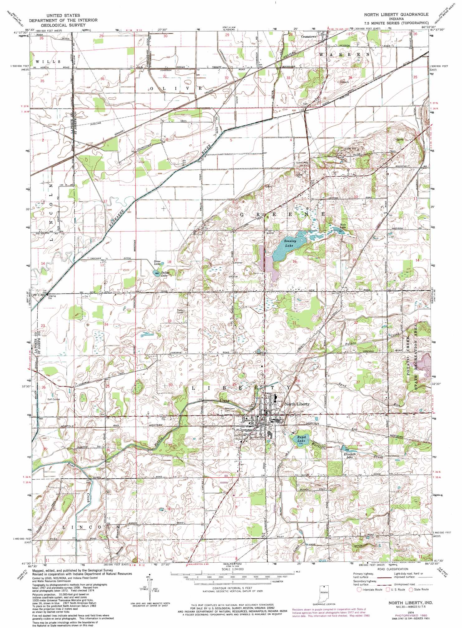
USGS Topo Quad 41086e4 - 1:24,000 scale
| Topo Map Name: | North Liberty |
| USGS Topo Quad ID: | 41086e4 |
| Print Size: | ca. 21 1/4" wide x 27" high |
| Southeast Coordinates: | 41.5° N latitude / 86.375° W longitude |
| Map Center Coordinates: | 41.5625° N latitude / 86.4375° W longitude |
| U.S. State: | IN |
| Filename: | o41086e4.jpg |
| Download Map JPG Image: | North Liberty topo map 1:24,000 scale |
| Map Type: | Topographic |
| Topo Series: | 7.5´ |
| Map Scale: | 1:24,000 |
| Source of Map Images: | United States Geological Survey (USGS) |
| Alternate Map Versions: |
North Liberty IN 1958, updated 1961 Download PDF Buy paper map North Liberty IN 1958, updated 1961 Download PDF Buy paper map North Liberty IN 1974, updated 1975 Download PDF Buy paper map North Liberty IN 1974, updated 1980 Download PDF Buy paper map North Liberty IN 2010 Download PDF Buy paper map North Liberty IN 2013 Download PDF Buy paper map North Liberty IN 2016 Download PDF Buy paper map |
1:24,000 Topo Quads surrounding North Liberty
New Buffalo East |
Three Oaks |
Galien |
Niles West |
Niles East |
Springville |
New Carlisle |
Lydick |
South Bend West |
South Bend East |
Laporte East |
Stillwell |
North Liberty |
Lakeville |
Wyatt |
Kingsford Heights |
Hamlet |
Walkerton |
La Paz |
Bremen |
Knox West |
Knox East |
Donaldson |
Plymouth |
Inwood |
> Back to 41086e1 at 1:100,000 scale
> Back to 41086a1 at 1:250,000 scale
> Back to U.S. Topo Maps home
North Liberty topo map: Gazetteer
North Liberty: Canals
Aldrich Ditch elevation 219m 718′County Line Ditch elevation 216m 708′
Dixon Ditch elevation 213m 698′
Elmer Kane Lateral elevation 221m 725′
Geyer Ditch elevation 212m 695′
Laskowski Ditch elevation 213m 698′
Miller Ditch elevation 208m 682′
Niespodziany Ditch elevation 216m 708′
Roda Ditch elevation 218m 715′
North Liberty: Lakes
Dine Lake elevation 210m 688′Dollar Lake elevation 211m 692′
Elizabeth Lake elevation 227m 744′
Kale Lake elevation 220m 721′
Rupel Lake elevation 218m 715′
Sousley Lake elevation 224m 734′
North Liberty: Populated Places
Crumstown elevation 217m 711′North Liberty elevation 223m 731′
North Liberty: Streams
Kartoffel Creek elevation 220m 721′Potato Creek elevation 211m 692′
Spud Run elevation 219m 718′
North Liberty digital topo map on disk
Buy this North Liberty topo map showing relief, roads, GPS coordinates and other geographical features, as a high-resolution digital map file on DVD:
Northern Illinois, Northern Indiana & Southwestern Michigan
Buy digital topo maps: Northern Illinois, Northern Indiana & Southwestern Michigan