Westville Topo Map Indiana
To zoom in, hover over the map of Westville
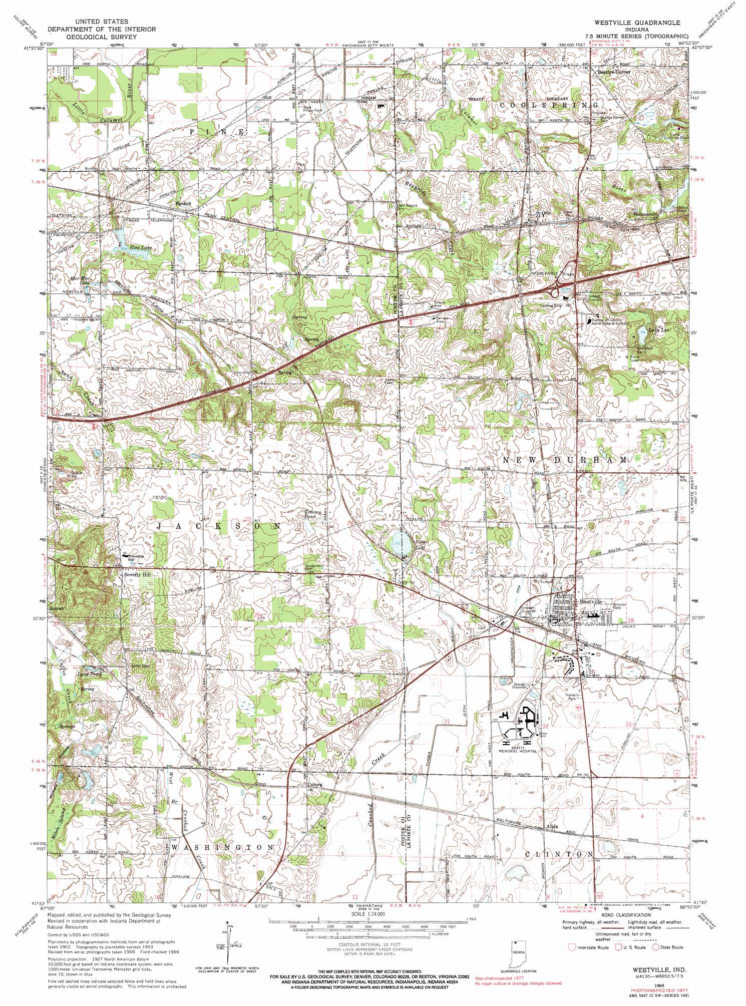
USGS Topo Quad 41086e8 - 1:24,000 scale
| Topo Map Name: | Westville |
| USGS Topo Quad ID: | 41086e8 |
| Print Size: | ca. 21 1/4" wide x 27" high |
| Southeast Coordinates: | 41.5° N latitude / 86.875° W longitude |
| Map Center Coordinates: | 41.5625° N latitude / 86.9375° W longitude |
| U.S. State: | IN |
| Filename: | o41086e8.jpg |
| Download Map JPG Image: | Westville topo map 1:24,000 scale |
| Map Type: | Topographic |
| Topo Series: | 7.5´ |
| Map Scale: | 1:24,000 |
| Source of Map Images: | United States Geological Survey (USGS) |
| Alternate Map Versions: |
Westville IN 1953, updated 1955 Download PDF Buy paper map Westville IN 1962, updated 1964 Download PDF Buy paper map Westville IN 1969, updated 1971 Download PDF Buy paper map Westville IN 1969, updated 1983 Download PDF Buy paper map Westville IN 2010 Download PDF Buy paper map Westville IN 2013 Download PDF Buy paper map Westville IN 2016 Download PDF Buy paper map |
1:24,000 Topo Quads surrounding Westville
New Buffalo West |
New Buffalo East |
|||
Ogden Dunes |
Dune Acres |
Michigan City West |
Michigan City East |
Springville |
Portage |
Chesterton |
Westville |
Laporte West |
Laporte East |
Palmer |
Valparaiso |
Wanatah |
Hanna |
Kingsford Heights |
Hebron |
Kouts |
La Crosse |
English Lake |
Knox West |
> Back to 41086e1 at 1:100,000 scale
> Back to 41086a1 at 1:250,000 scale
> Back to U.S. Topo Maps home
Westville topo map: Gazetteer
Westville: Airports
Orthodontic Strip elevation 241m 790′Westville: Canals
Crumpacker Arm elevation 238m 780′Forbes Ditch elevation 231m 757′
Wright Arm elevation 237m 777′
Westville: Crossings
Interchange 6 elevation 240m 787′Westville: Dams
Camp Red Mill Lake Dam elevation 222m 728′Rice Lake Dam elevation 206m 675′
Westville: Lakes
Clear Lake elevation 236m 774′Lake Lee elevation 242m 793′
Long Pond elevation 226m 741′
Mar-Mac Lake elevation 209m 685′
Tommy Pond elevation 241m 790′
Westville: Populated Places
Alida elevation 238m 780′Beattys Corner elevation 224m 734′
Beverly Hill elevation 262m 859′
Burdick elevation 207m 679′
Coburg elevation 237m 777′
Holmesville elevation 234m 767′
Otis elevation 229m 751′
Westville elevation 242m 793′
Westville: Reservoirs
Rice Lake elevation 206m 675′Westville: Streams
Reynolds Creek elevation 199m 652′Westville: Valleys
Hungry Hollow elevation 234m 767′Westville digital topo map on disk
Buy this Westville topo map showing relief, roads, GPS coordinates and other geographical features, as a high-resolution digital map file on DVD:
Northern Illinois, Northern Indiana & Southwestern Michigan
Buy digital topo maps: Northern Illinois, Northern Indiana & Southwestern Michigan