Michigan City West Topo Map Indiana
To zoom in, hover over the map of Michigan City West
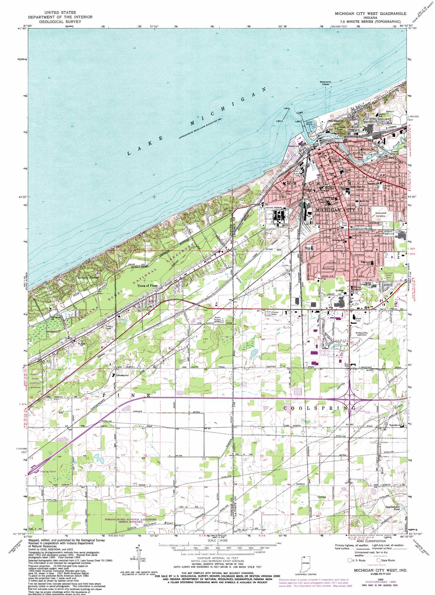
USGS Topo Quad 41086f8 - 1:24,000 scale
| Topo Map Name: | Michigan City West |
| USGS Topo Quad ID: | 41086f8 |
| Print Size: | ca. 21 1/4" wide x 27" high |
| Southeast Coordinates: | 41.625° N latitude / 86.875° W longitude |
| Map Center Coordinates: | 41.6875° N latitude / 86.9375° W longitude |
| U.S. State: | IN |
| Filename: | o41086f8.jpg |
| Download Map JPG Image: | Michigan City West topo map 1:24,000 scale |
| Map Type: | Topographic |
| Topo Series: | 7.5´ |
| Map Scale: | 1:24,000 |
| Source of Map Images: | United States Geological Survey (USGS) |
| Alternate Map Versions: |
Michigan City West IN 1953, updated 1955 Download PDF Buy paper map Michigan City West IN 1962, updated 1964 Download PDF Buy paper map Michigan City West IN 1969, updated 1971 Download PDF Buy paper map Michigan City West IN 1969, updated 1981 Download PDF Buy paper map Michigan City West IN 1969, updated 1989 Download PDF Buy paper map Michigan City West IN 1969, updated 1989 Download PDF Buy paper map Michigan City West IN 1994, updated 1999 Download PDF Buy paper map Michigan City West IN 2010 Download PDF Buy paper map Michigan City West IN 2013 Download PDF Buy paper map Michigan City West IN 2016 Download PDF Buy paper map |
1:24,000 Topo Quads surrounding Michigan City West
New Buffalo West |
New Buffalo East |
|||
Ogden Dunes |
Dune Acres |
Michigan City West |
Michigan City East |
Springville |
Portage |
Chesterton |
Westville |
Laporte West |
Laporte East |
Palmer |
Valparaiso |
Wanatah |
Hanna |
Kingsford Heights |
> Back to 41086e1 at 1:100,000 scale
> Back to 41086a1 at 1:250,000 scale
> Back to U.S. Topo Maps home
Michigan City West topo map: Gazetteer
Michigan City West: Airports
Michigan City Municipal Airport elevation 204m 669′Michigan City West: Canals
Brown Ditch elevation 182m 597′Carver Ditch elevation 198m 649′
Kieffer Gruenke Ditch elevation 201m 659′
Kintzele Ditch elevation 186m 610′
Michigan City West: Harbors
Michigan City Harbor elevation 175m 574′Outer Basin elevation 175m 574′
Michigan City West: Parks
Ames Field elevation 189m 620′Cleveland Park elevation 188m 616′
Gardena Playground elevation 192m 629′
Gill Field elevation 191m 626′
Hanson Park elevation 179m 587′
Pullman Field elevation 183m 600′
Washington Park elevation 181m 593′
Zilla Park elevation 189m 620′
Michigan City West: Populated Places
Beverly Shores elevation 189m 620′Michigan City elevation 191m 626′
Town of Pines elevation 191m 626′
Michigan City West: Reservoirs
Spychalskis Pond elevation 216m 708′Michigan City West: Streams
Trail Creek elevation 175m 574′Michigan City West: Summits
Mount Baldy elevation 185m 606′Michigan City West digital topo map on disk
Buy this Michigan City West topo map showing relief, roads, GPS coordinates and other geographical features, as a high-resolution digital map file on DVD:
Northern Illinois, Northern Indiana & Southwestern Michigan
Buy digital topo maps: Northern Illinois, Northern Indiana & Southwestern Michigan