Niles East Topo Map Michigan
To zoom in, hover over the map of Niles East
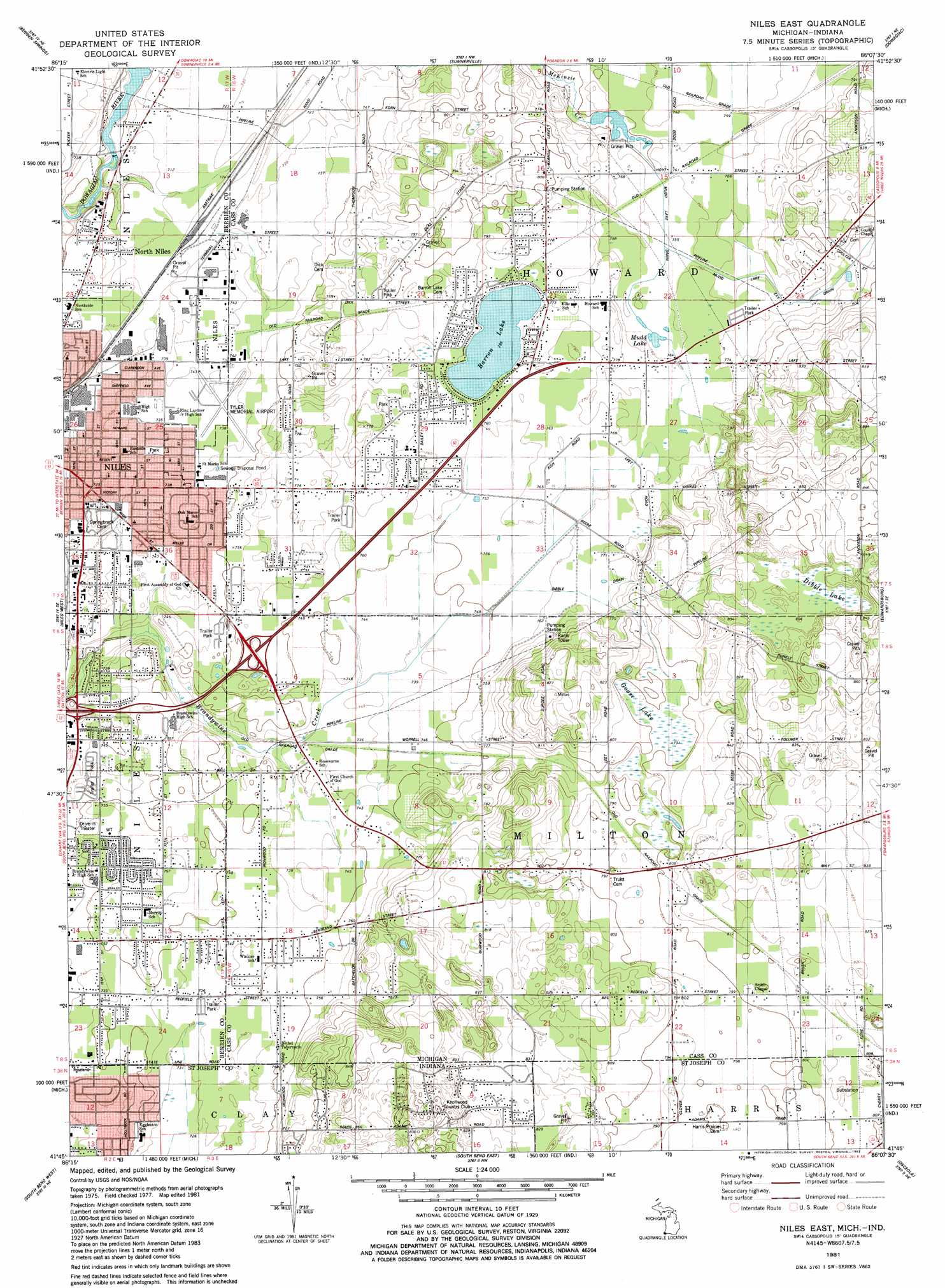
USGS Topo Quad 41086g2 - 1:24,000 scale
| Topo Map Name: | Niles East |
| USGS Topo Quad ID: | 41086g2 |
| Print Size: | ca. 21 1/4" wide x 27" high |
| Southeast Coordinates: | 41.75° N latitude / 86.125° W longitude |
| Map Center Coordinates: | 41.8125° N latitude / 86.1875° W longitude |
| U.S. States: | MI, IN |
| Filename: | o41086g2.jpg |
| Download Map JPG Image: | Niles East topo map 1:24,000 scale |
| Map Type: | Topographic |
| Topo Series: | 7.5´ |
| Map Scale: | 1:24,000 |
| Source of Map Images: | United States Geological Survey (USGS) |
| Alternate Map Versions: |
Niles East MI 1981, updated 1982 Download PDF Buy paper map Niles East MI 2011 Download PDF Buy paper map Niles East MI 2014 Download PDF Buy paper map Niles East MI 2016 Download PDF Buy paper map |
1:24,000 Topo Quads surrounding Niles East
Benton Harbor |
Sodus |
Sister Lakes |
Twin Lakes |
Decatur |
Baroda |
Berrien Springs |
Sumnerville |
Dowagiac |
Vandalia |
Galien |
Niles West |
Niles East |
Edwardsburg |
Adamsville |
Lydick |
South Bend West |
South Bend East |
Osceola |
Elkhart |
North Liberty |
Lakeville |
Wyatt |
Wakarusa |
Foraker |
> Back to 41086e1 at 1:100,000 scale
> Back to 41086a1 at 1:250,000 scale
> Back to U.S. Topo Maps home
Niles East topo map: Gazetteer
Niles East: Airports
Crump Airport elevation 226m 741′Jerry Tyler Memorial Airport elevation 225m 738′
Rentz Ultralight Airport elevation 244m 800′
Niles East: Canals
Mudd Lake Drain elevation 227m 744′Niles East: Lakes
Barron Lake elevation 230m 754′Mudd Lake elevation 232m 761′
Niles East: Parks
Birkholm Park elevation 220m 721′Eastside Park elevation 224m 734′
Fulkerson Park elevation 232m 761′
Pepper Martin Park elevation 235m 770′
Saathoff Park elevation 217m 711′
Smith's Chapel Historical Marker elevation 244m 800′
Southside Park elevation 224m 734′
Tot Park elevation 217m 711′
Troost Park elevation 215m 705′
Niles East: Populated Places
Birch Crest Estates elevation 229m 751′Franklin Woods Mobile Home Park elevation 225m 738′
Marlin Village Mobile Home Community elevation 238m 780′
Niles Pines Mobile Estates elevation 234m 767′
North Niles elevation 217m 711′
Ontario Place Mobile Home Park elevation 225m 738′
Silverbrook Manufactured Home Community elevation 227m 744′
Niles East: Post Offices
Barron Lake Post Office (historical) elevation 234m 767′Niles Post Office elevation 216m 708′
Truitts Post Office (historical) elevation 244m 800′
Niles East: Streams
Mudd Lake Extension Drain elevation 231m 757′Niles East: Swamps
Dibble Lake elevation 245m 803′Goose Lake elevation 243m 797′
Niles East digital topo map on disk
Buy this Niles East topo map showing relief, roads, GPS coordinates and other geographical features, as a high-resolution digital map file on DVD:
Northern Illinois, Northern Indiana & Southwestern Michigan
Buy digital topo maps: Northern Illinois, Northern Indiana & Southwestern Michigan