New Buffalo East Topo Map Michigan
To zoom in, hover over the map of New Buffalo East
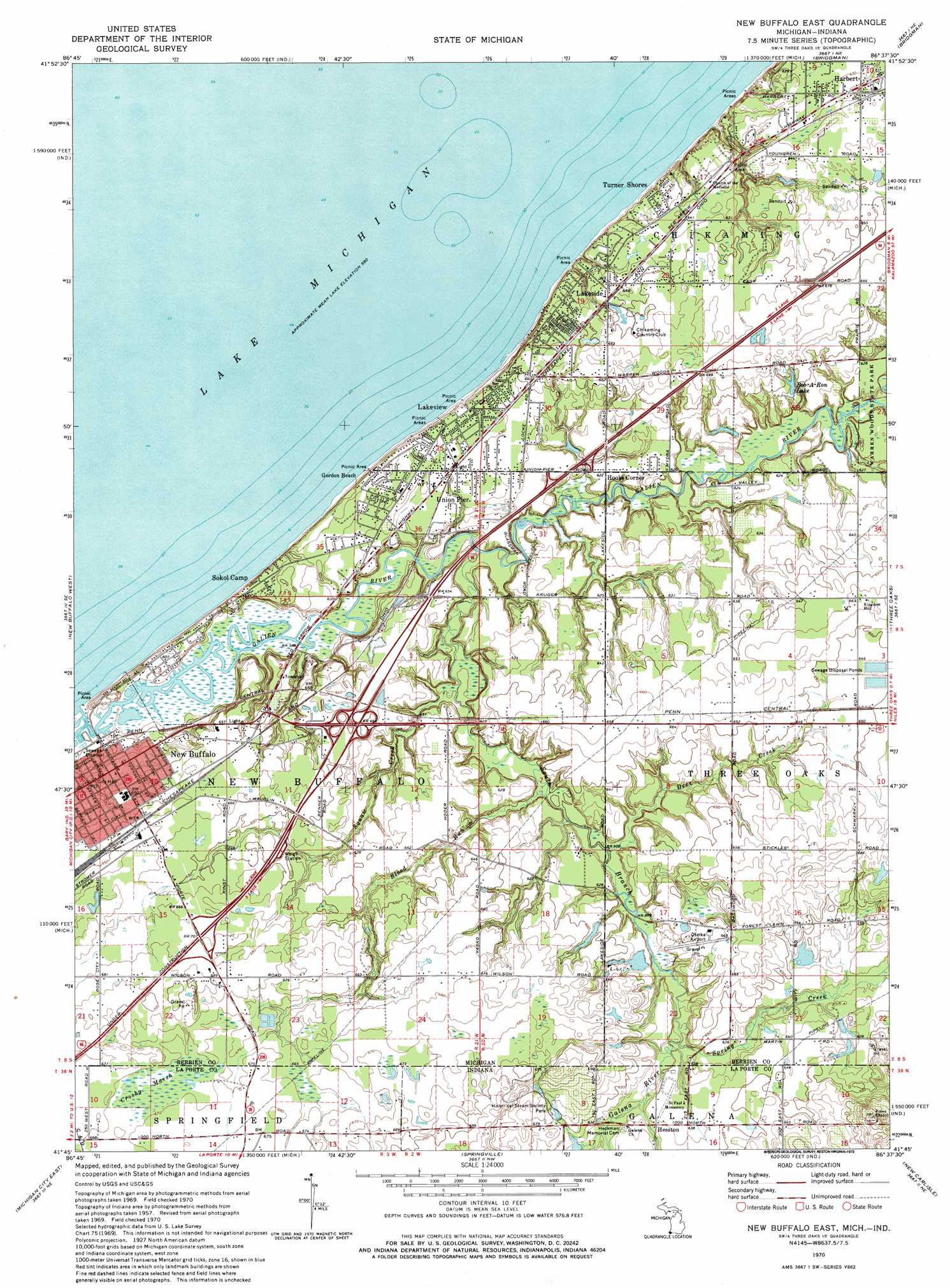
USGS Topo Quad 41086g6 - 1:24,000 scale
| Topo Map Name: | New Buffalo East |
| USGS Topo Quad ID: | 41086g6 |
| Print Size: | ca. 21 1/4" wide x 27" high |
| Southeast Coordinates: | 41.75° N latitude / 86.625° W longitude |
| Map Center Coordinates: | 41.8125° N latitude / 86.6875° W longitude |
| U.S. States: | MI, IN |
| Filename: | o41086g6.jpg |
| Download Map JPG Image: | New Buffalo East topo map 1:24,000 scale |
| Map Type: | Topographic |
| Topo Series: | 7.5´ |
| Map Scale: | 1:24,000 |
| Source of Map Images: | United States Geological Survey (USGS) |
| Alternate Map Versions: |
New Buffalo East MI 1970, updated 1973 Download PDF Buy paper map New Buffalo East MI 2011 Download PDF Buy paper map New Buffalo East MI 2014 Download PDF Buy paper map New Buffalo East MI 2016 Download PDF Buy paper map |
1:24,000 Topo Quads surrounding New Buffalo East
Stevensville |
Benton Harbor |
|||
Bridgman |
Baroda |
|||
New Buffalo West |
New Buffalo East |
Three Oaks |
Galien |
|
Michigan City West |
Michigan City East |
Springville |
New Carlisle |
Lydick |
Westville |
Laporte West |
Laporte East |
Stillwell |
North Liberty |
> Back to 41086e1 at 1:100,000 scale
> Back to 41086a1 at 1:250,000 scale
> Back to U.S. Topo Maps home
New Buffalo East topo map: Gazetteer
New Buffalo East: Airports
Oselka Airport elevation 201m 659′New Buffalo East: Crossings
Interchange 1 elevation 214m 702′Interchange 4A elevation 202m 662′
Interchange 4B elevation 198m 649′
Interchange 6 elevation 192m 629′
New Buffalo East: Lakes
Bob-A-Ron Lake elevation 200m 656′New Buffalo East: Parks
Chikaming Township Park elevation 207m 679′Lakeside Inn Historical Marker elevation 204m 669′
New Buffalo Public Beach elevation 181m 593′
New Buffalo Welcome Center Historical Marker elevation 212m 695′
New Buffalo East: Populated Places
Gordon Beach elevation 189m 620′Harbert elevation 190m 623′
Hesston elevation 195m 639′
Hooks Corner elevation 192m 629′
Lakeside elevation 195m 639′
Lakeview elevation 191m 626′
Lakewood Mobile Home Estates elevation 209m 685′
New Buffalo elevation 195m 639′
Sokol Camp elevation 184m 603′
Turner Shores elevation 187m 613′
Union Pier elevation 191m 626′
New Buffalo East: Post Offices
Chikaming Post Office (historical) elevation 193m 633′Harbert Post Office elevation 191m 626′
Lakeside Post Office elevation 197m 646′
New Buffalo Post Office elevation 193m 633′
Union Pier Post Office elevation 191m 626′
New Buffalo East: Streams
Blood Run elevation 185m 606′Deer Creek elevation 190m 623′
Galena River elevation 187m 613′
Galien River elevation 178m 583′
South Branch Galien River elevation 185m 606′
Spring Creek elevation 187m 613′
Squaw Creek elevation 185m 606′
New Buffalo East: Swamps
Crosby Marsh elevation 203m 666′Crosby Marsh elevation 203m 666′
New Buffalo East digital topo map on disk
Buy this New Buffalo East topo map showing relief, roads, GPS coordinates and other geographical features, as a high-resolution digital map file on DVD:
Northern Illinois, Northern Indiana & Southwestern Michigan
Buy digital topo maps: Northern Illinois, Northern Indiana & Southwestern Michigan