Dowagiac Topo Map Michigan
To zoom in, hover over the map of Dowagiac
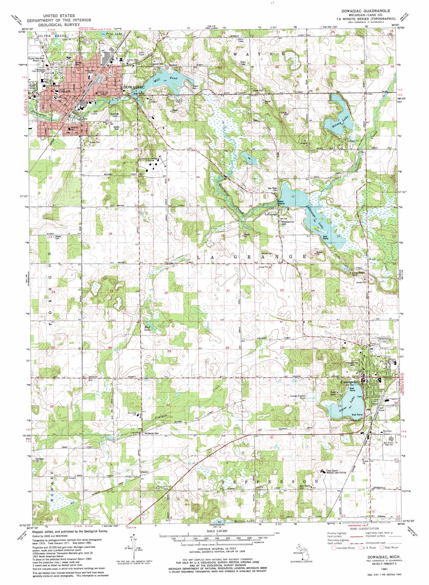
USGS Topo Quad 41086h1 - 1:24,000 scale
| Topo Map Name: | Dowagiac |
| USGS Topo Quad ID: | 41086h1 |
| Print Size: | ca. 21 1/4" wide x 27" high |
| Southeast Coordinates: | 41.875° N latitude / 86° W longitude |
| Map Center Coordinates: | 41.9375° N latitude / 86.0625° W longitude |
| U.S. State: | MI |
| Filename: | o41086h1.jpg |
| Download Map JPG Image: | Dowagiac topo map 1:24,000 scale |
| Map Type: | Topographic |
| Topo Series: | 7.5´ |
| Map Scale: | 1:24,000 |
| Source of Map Images: | United States Geological Survey (USGS) |
| Alternate Map Versions: |
Dowagiac MI 1981, updated 1982 Download PDF Buy paper map Dowagiac MI 2011 Download PDF Buy paper map Dowagiac MI 2014 Download PDF Buy paper map Dowagiac MI 2016 Download PDF Buy paper map |
1:24,000 Topo Quads surrounding Dowagiac
Coloma |
Hartford |
Lawrence |
Paw Paw |
Lawton |
Sodus |
Sister Lakes |
Twin Lakes |
Decatur |
Marcellus |
Berrien Springs |
Sumnerville |
Dowagiac |
Vandalia |
Jones |
Niles West |
Niles East |
Edwardsburg |
Adamsville |
Mottville |
South Bend West |
South Bend East |
Osceola |
Elkhart |
Bristol |
> Back to 41086e1 at 1:100,000 scale
> Back to 41086a1 at 1:250,000 scale
> Back to U.S. Topo Maps home
Dowagiac topo map: Gazetteer
Dowagiac: Airports
Lee Memorial Hospital Heliport elevation 235m 770′Dowagiac: Lakes
Kelsey Lake elevation 247m 810′La Grange Lake elevation 241m 790′
Mill Pond elevation 235m 770′
Mud Lake elevation 242m 793′
Pine Lake elevation 224m 734′
Stone Lake elevation 259m 849′
Dowagiac: Parks
Beckwith Park elevation 235m 770′Burke Park elevation 231m 757′
Cass County Courthouse Historical Marker elevation 274m 898′
Episcopal Church Historical Marker elevation 235m 770′
Farr Park elevation 235m 770′
James E Heddon Park elevation 234m 767′
Northwest Park elevation 227m 744′
Optimist Park elevation 228m 748′
Rotary Park elevation 255m 836′
Rudolphi Wildlife Refuge elevation 240m 787′
Rudy Park elevation 238m 780′
Saint Paul's Church Historical Marker elevation 235m 770′
Veterans Memorial and Beeson Street Park elevation 257m 843′
Walter Ward Park elevation 230m 754′
Water Tower Park elevation 235m 770′
Dowagiac: Populated Places
Cassopolis elevation 271m 889′Dailey elevation 250m 820′
Dowagiac elevation 232m 761′
La Grange elevation 247m 810′
Dowagiac: Post Offices
Cassopolis Post Office elevation 268m 879′Dailey Post Office (historical) elevation 250m 820′
Dowagiac Post Office elevation 234m 767′
La Grange Post Office (historical) elevation 247m 810′
Dowagiac digital topo map on disk
Buy this Dowagiac topo map showing relief, roads, GPS coordinates and other geographical features, as a high-resolution digital map file on DVD:
Northern Illinois, Northern Indiana & Southwestern Michigan
Buy digital topo maps: Northern Illinois, Northern Indiana & Southwestern Michigan