Enos Topo Map Indiana
To zoom in, hover over the map of Enos
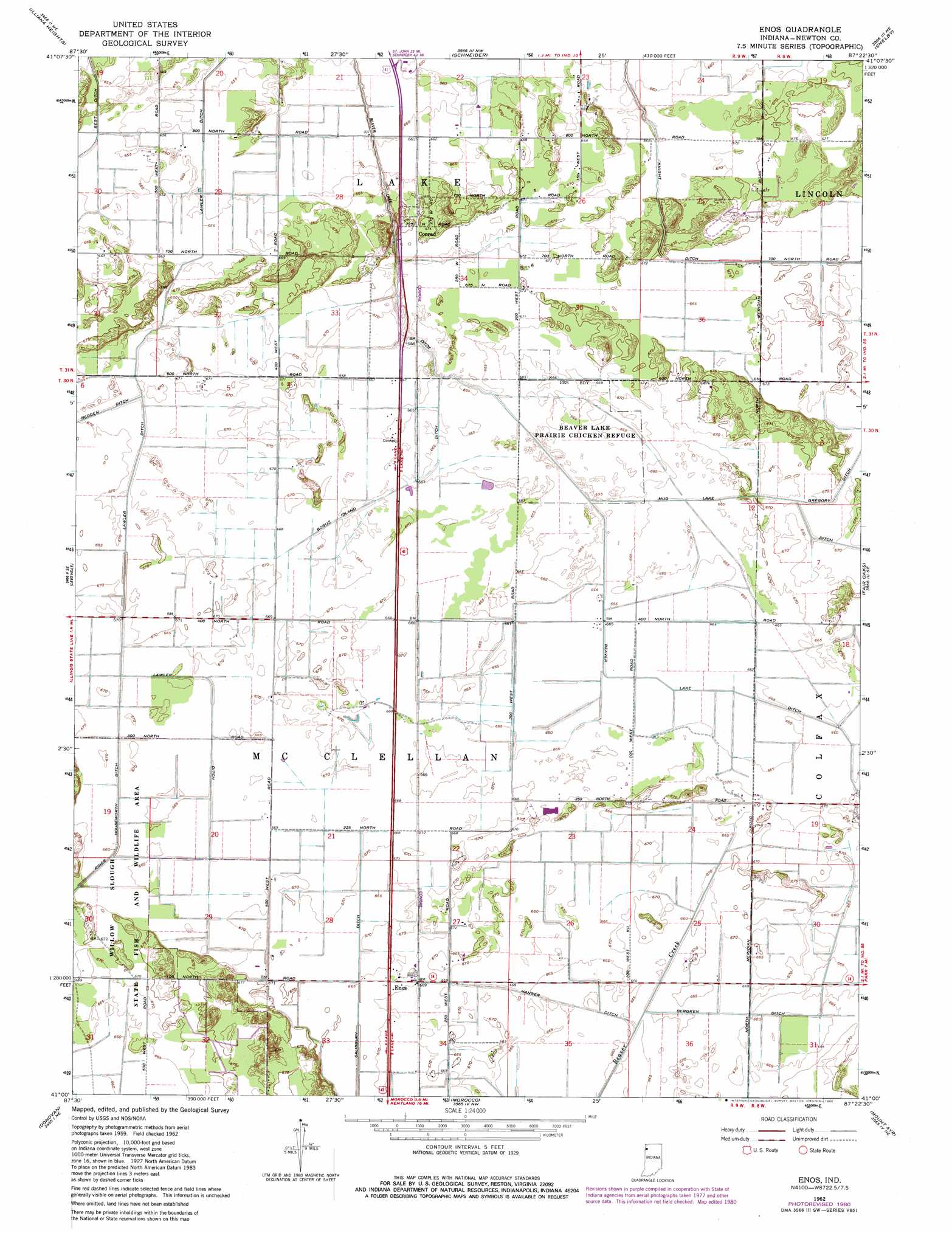
USGS Topo Quad 41087a4 - 1:24,000 scale
| Topo Map Name: | Enos |
| USGS Topo Quad ID: | 41087a4 |
| Print Size: | ca. 21 1/4" wide x 27" high |
| Southeast Coordinates: | 41° N latitude / 87.375° W longitude |
| Map Center Coordinates: | 41.0625° N latitude / 87.4375° W longitude |
| U.S. State: | IN |
| Filename: | o41087a4.jpg |
| Download Map JPG Image: | Enos topo map 1:24,000 scale |
| Map Type: | Topographic |
| Topo Series: | 7.5´ |
| Map Scale: | 1:24,000 |
| Source of Map Images: | United States Geological Survey (USGS) |
| Alternate Map Versions: |
Enos IN 1962, updated 1964 Download PDF Buy paper map Enos IN 1962, updated 1980 Download PDF Buy paper map Enos IN 1962, updated 1980 Download PDF Buy paper map Enos IN 2010 Download PDF Buy paper map Enos IN 2013 Download PDF Buy paper map Enos IN 2016 Download PDF Buy paper map |
1:24,000 Topo Quads surrounding Enos
Beecher West |
Beecher East |
Lowell |
Leroy |
Hebron |
Momence |
Illiana Heights |
Schneider |
Shelby |
Demotte |
Saint Anne |
Leesville |
Enos |
Fair Oaks |
Parr |
Beaverville |
Donovan |
Morocco |
Mount Ayr |
Rensselaer |
Watseka |
Sheldon |
Kentland |
Goodland |
Remington |
> Back to 41087a1 at 1:100,000 scale
> Back to 41086a1 at 1:250,000 scale
> Back to U.S. Topo Maps home
Enos topo map: Gazetteer
Enos: Canals
Beaver Lake Ditch elevation 201m 659′Bergren Ditch elevation 203m 666′
Bogus Island Ditch elevation 203m 666′
Hanger Ditch elevation 204m 669′
Lawler Ditch elevation 205m 672′
Mud Lake Ditch elevation 204m 669′
Salisbury Ditch elevation 204m 669′
Enos: Parks
Beaver Lake Prairie Chicken Refuge elevation 203m 666′Enos: Populated Places
Conrad elevation 207m 679′Enos elevation 205m 672′
Enos digital topo map on disk
Buy this Enos topo map showing relief, roads, GPS coordinates and other geographical features, as a high-resolution digital map file on DVD:
Northern Illinois, Northern Indiana & Southwestern Michigan
Buy digital topo maps: Northern Illinois, Northern Indiana & Southwestern Michigan