Kankakee Topo Map Illinois
To zoom in, hover over the map of Kankakee
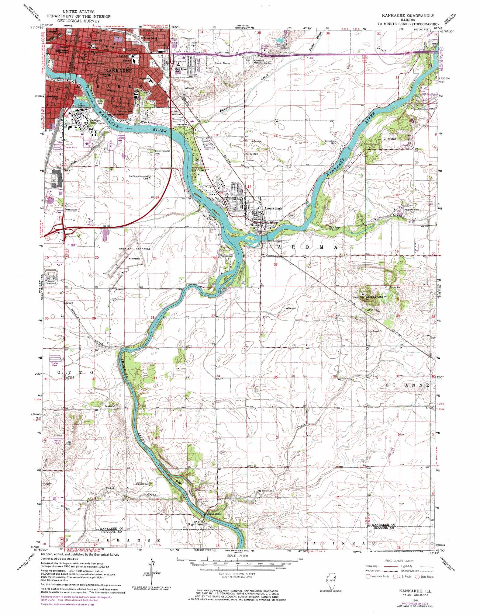
USGS Topo Quad 41087a7 - 1:24,000 scale
| Topo Map Name: | Kankakee |
| USGS Topo Quad ID: | 41087a7 |
| Print Size: | ca. 21 1/4" wide x 27" high |
| Southeast Coordinates: | 41° N latitude / 87.75° W longitude |
| Map Center Coordinates: | 41.0625° N latitude / 87.8125° W longitude |
| U.S. State: | IL |
| Filename: | o41087a7.jpg |
| Download Map JPG Image: | Kankakee topo map 1:24,000 scale |
| Map Type: | Topographic |
| Topo Series: | 7.5´ |
| Map Scale: | 1:24,000 |
| Source of Map Images: | United States Geological Survey (USGS) |
| Alternate Map Versions: |
Kankakee IL 1964, updated 1965 Download PDF Buy paper map Kankakee IL 1964, updated 1974 Download PDF Buy paper map Kankakee IL 2012 Download PDF Buy paper map Kankakee IL 2015 Download PDF Buy paper map |
1:24,000 Topo Quads surrounding Kankakee
Symerton |
Wilton Center |
Peotone |
Beecher West |
Beecher East |
Bonfield |
Bourbonnais |
Bradley |
Momence |
Illiana Heights |
Herscher |
West Kankakee |
Kankakee |
Saint Anne |
Leesville |
Piper City Ne |
Clifton |
L'Erable |
Beaverville |
Donovan |
La Hogue |
Gilman |
Crescent |
Watseka |
Sheldon |
> Back to 41087a1 at 1:100,000 scale
> Back to 41086a1 at 1:250,000 scale
> Back to U.S. Topo Maps home
Kankakee topo map: Gazetteer
Kankakee: Airports
Greater Kankakee Airport elevation 187m 613′Saint Marys Hospital Heliport elevation 185m 606′
Kankakee: Crossings
Interchange 308 elevation 190m 623′Interchange 312 elevation 200m 656′
Kankakee: Islands
Sugar Island elevation 187m 613′Kankakee: Parks
Beckman Park elevation 187m 613′Cobb Park elevation 184m 603′
Gooseberry Island Nature Preserve elevation 184m 603′
Iroquois Woods Nature Preserve elevation 186m 610′
Jobbers Park elevation 181m 593′
Pierson Park elevation 195m 639′
River Road Park elevation 190m 623′
Riverview Historic District elevation 189m 620′
Snow Park elevation 199m 652′
Strasma Park elevation 189m 620′
Kankakee: Populated Places
Aroma Park elevation 188m 616′Kankakee elevation 200m 656′
Sammons Point elevation 194m 636′
Sugar Island elevation 189m 620′
Kankakee: Post Offices
Kankakee Post Office elevation 200m 656′Kankakee: Streams
Baker Creek elevation 182m 597′Brainard Creek elevation 184m 603′
Deer Creek elevation 184m 603′
Exline Slough elevation 187m 613′
Gar Creek elevation 183m 600′
Iroquois River elevation 182m 597′
Minnie Creek elevation 182m 597′
Spring Creek elevation 182m 597′
Trail Creek elevation 182m 597′
Kankakee: Summits
Mount Langham elevation 221m 725′Kankakee digital topo map on disk
Buy this Kankakee topo map showing relief, roads, GPS coordinates and other geographical features, as a high-resolution digital map file on DVD:
Northern Illinois, Northern Indiana & Southwestern Michigan
Buy digital topo maps: Northern Illinois, Northern Indiana & Southwestern Michigan