Bourbonnais Topo Map Illinois
To zoom in, hover over the map of Bourbonnais
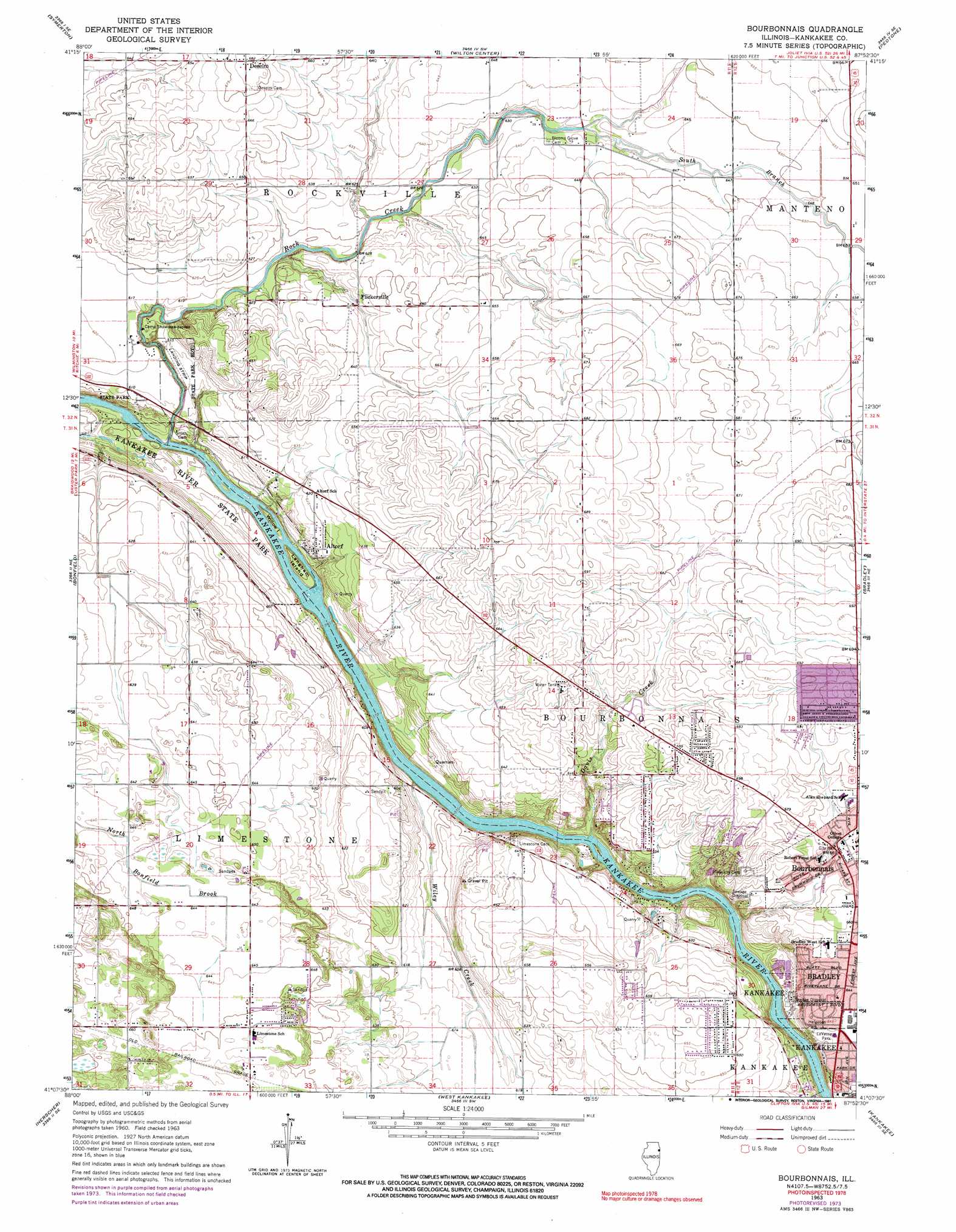
USGS Topo Quad 41087b8 - 1:24,000 scale
| Topo Map Name: | Bourbonnais |
| USGS Topo Quad ID: | 41087b8 |
| Print Size: | ca. 21 1/4" wide x 27" high |
| Southeast Coordinates: | 41.125° N latitude / 87.875° W longitude |
| Map Center Coordinates: | 41.1875° N latitude / 87.9375° W longitude |
| U.S. State: | IL |
| Filename: | o41087b8.jpg |
| Download Map JPG Image: | Bourbonnais topo map 1:24,000 scale |
| Map Type: | Topographic |
| Topo Series: | 7.5´ |
| Map Scale: | 1:24,000 |
| Source of Map Images: | United States Geological Survey (USGS) |
| Alternate Map Versions: |
Bourbonnais IL 1963, updated 1965 Download PDF Buy paper map Bourbonnais IL 1963, updated 1974 Download PDF Buy paper map Bourbonnais IL 1963, updated 1991 Download PDF Buy paper map Bourbonnais IL 2012 Download PDF Buy paper map Bourbonnais IL 2015 Download PDF Buy paper map |
1:24,000 Topo Quads surrounding Bourbonnais
Channahon |
Elwood |
Manhattan |
Frankfort |
Steger |
Wilmington |
Symerton |
Wilton Center |
Peotone |
Beecher West |
Essex |
Bonfield |
Bourbonnais |
Bradley |
Momence |
Buckingham |
Herscher |
West Kankakee |
Kankakee |
Saint Anne |
Cabery |
Piper City Ne |
Clifton |
L'Erable |
Beaverville |
> Back to 41087a1 at 1:100,000 scale
> Back to 41086a1 at 1:250,000 scale
> Back to U.S. Topo Maps home
Bourbonnais topo map: Gazetteer
Bourbonnais: Airports
Karlock Airport elevation 203m 666′Bourbonnais: Islands
Langham Island elevation 171m 561′Willow Island elevation 169m 554′
Bourbonnais: Parks
Bourbonnais Geological Area Nature Preserve elevation 195m 639′Gettysburg Park elevation 209m 685′
Helgesen Park elevation 189m 620′
Kankakee River Nature Preserve elevation 171m 561′
LaVasseur Park elevation 193m 633′
Limestone Park elevation 203m 666′
Bourbonnais: Populated Places
Altorf elevation 183m 600′Bourbonnais elevation 198m 649′
Deselm elevation 208m 682′
Flickerville elevation 193m 633′
Limestone elevation 200m 656′
Bourbonnais: Streams
Davis Creek elevation 177m 580′Rock Creek elevation 169m 554′
South Branch Rock Creek elevation 192m 629′
Wiley Creek elevation 175m 574′
Bourbonnais digital topo map on disk
Buy this Bourbonnais topo map showing relief, roads, GPS coordinates and other geographical features, as a high-resolution digital map file on DVD:
Northern Illinois, Northern Indiana & Southwestern Michigan
Buy digital topo maps: Northern Illinois, Northern Indiana & Southwestern Michigan