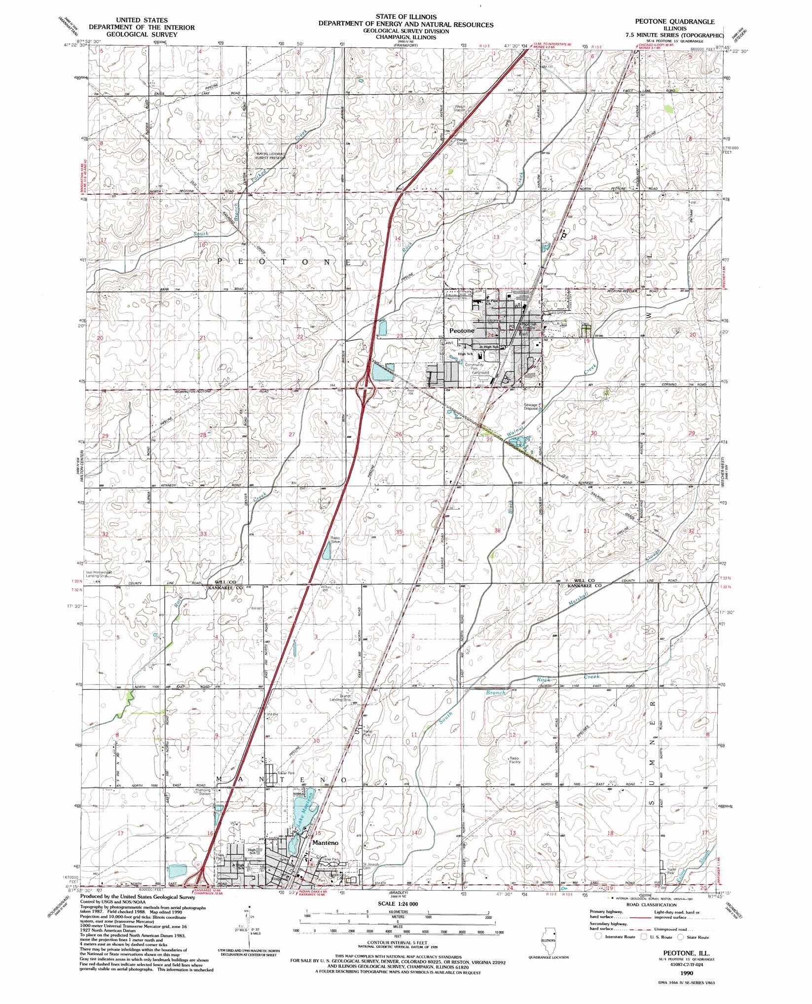
Peotone Topo Map Illinois
To zoom in, hover over the map of Peotone
USGS Topo Quad 41087c7 - 1:24,000 scale
| Topo Map Name: | Peotone |
| USGS Topo Quad ID: | 41087c7 |
| Print Size: | ca. 21 1/4" wide x 27" high |
| Southeast Coordinates: | 41.25° N latitude / 87.75° W longitude |
| Map Center Coordinates: | 41.3125° N latitude / 87.8125° W longitude |
| U.S. State: | IL |
| Filename: | o41087c7.jpg |
| Download Map JPG Image: | Peotone topo map 1:24,000 scale |
| Map Type: | Topographic |
| Topo Series: | 7.5´ |
| Map Scale: | 1:24,000 |
| Source of Map Images: | United States Geological Survey (USGS) |
| Alternate Map Versions: |
Peotone IL 1953, updated 1955 Download PDF Buy paper map Peotone IL 1953, updated 1974 Download PDF Buy paper map Peotone IL 1953, updated 1981 Download PDF Buy paper map Peotone IL 1990, updated 1991 Download PDF Buy paper map Peotone IL 2012 Download PDF Buy paper map Peotone IL 2015 Download PDF Buy paper map |
1:24,000 Topo Quads surrounding Peotone
Joliet |
Mokena |
Tinley Park |
Harvey |
Calumet City |
Elwood |
Manhattan |
Frankfort |
Steger |
Dyer |
Symerton |
Wilton Center |
Peotone |
Beecher West |
Beecher East |
Bonfield |
Bourbonnais |
Bradley |
Momence |
Illiana Heights |
Herscher |
West Kankakee |
Kankakee |
Saint Anne |
Leesville |
> Back to 41087a1 at 1:100,000 scale
> Back to 41086a1 at 1:250,000 scale
> Back to U.S. Topo Maps home
Peotone topo map: Gazetteer
Peotone: Airports
Brandt Airport elevation 209m 685′Brandt Landing Strip elevation 208m 682′
Peotone: Crossings
Interchange 322 elevation 208m 682′Interchange 327 elevation 214m 702′
Peotone: Lakes
Lake Manteno elevation 207m 679′Peotone: Parks
Hendrickson Park elevation 206m 675′Legion Park elevation 209m 685′
Peotone Community Park elevation 217m 711′
Thies Park elevation 206m 675′
Wayne Lehnert Forest Preserve elevation 218m 715′
Peotone: Populated Places
Manteno elevation 209m 685′Peotone elevation 215m 705′
Peotone: Post Offices
Peotone Post Office elevation 217m 711′Peotone: Streams
Black Walnut Creek elevation 204m 669′Marshall Slough elevation 204m 669′
Peotone digital topo map on disk
Buy this Peotone topo map showing relief, roads, GPS coordinates and other geographical features, as a high-resolution digital map file on DVD:
Northern Illinois, Northern Indiana & Southwestern Michigan
Buy digital topo maps: Northern Illinois, Northern Indiana & Southwestern Michigan