Mokena Topo Map Illinois
To zoom in, hover over the map of Mokena
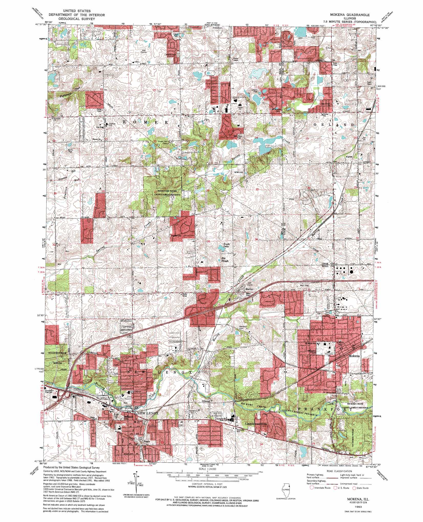
USGS Topo Quad 41087e8 - 1:24,000 scale
| Topo Map Name: | Mokena |
| USGS Topo Quad ID: | 41087e8 |
| Print Size: | ca. 21 1/4" wide x 27" high |
| Southeast Coordinates: | 41.5° N latitude / 87.875° W longitude |
| Map Center Coordinates: | 41.5625° N latitude / 87.9375° W longitude |
| U.S. State: | IL |
| Filename: | o41087e8.jpg |
| Download Map JPG Image: | Mokena topo map 1:24,000 scale |
| Map Type: | Topographic |
| Topo Series: | 7.5´ |
| Map Scale: | 1:24,000 |
| Source of Map Images: | United States Geological Survey (USGS) |
| Alternate Map Versions: |
Mokena IL 1929 Download PDF Buy paper map Mokena IL 1929, updated 1943 Download PDF Buy paper map Mokena IL 1953, updated 1955 Download PDF Buy paper map Mokena IL 1963, updated 1964 Download PDF Buy paper map Mokena IL 1963, updated 1974 Download PDF Buy paper map Mokena IL 1993, updated 1994 Download PDF Buy paper map Mokena IL 1998, updated 2002 Download PDF Buy paper map Mokena IL 2012 Download PDF Buy paper map Mokena IL 2015 Download PDF Buy paper map |
1:24,000 Topo Quads surrounding Mokena
Naperville |
Wheaton |
Hinsdale |
Berwyn |
Englewood |
Normantown |
Romeoville |
Sag Bridge |
Palos Park |
Blue Island |
Plainfield |
Joliet |
Mokena |
Tinley Park |
Harvey |
Channahon |
Elwood |
Manhattan |
Frankfort |
Steger |
Wilmington |
Symerton |
Wilton Center |
Peotone |
Beecher West |
> Back to 41087e1 at 1:100,000 scale
> Back to 41086a1 at 1:250,000 scale
> Back to U.S. Topo Maps home
Mokena topo map: Gazetteer
Mokena: Airports
Richards Heliport elevation 202m 662′Mokena: Crossings
Interchange 137 elevation 195m 639′Mokena: Dams
Hamburgh-Martin Number 6 Dam elevation 215m 705′Mokena: Lakes
Scuds Lake elevation 218m 715′Mokena: Parks
Corcoran Park elevation 188m 616′Culver Park elevation 222m 728′
Discovery Park elevation 216m 708′
Haines Wayside Park elevation 194m 636′
Haley Park elevation 215m 705′
Hickory Creek Barrens Nature Preserve elevation 203m 666′
Hickory Creek County Forest Preserve elevation 199m 652′
Lamers Park elevation 230m 754′
Lions Park elevation 210m 688′
Lower Spring Creek County Forest Preserve elevation 197m 646′
Messenger Woods County Forest Preserve elevation 212m 695′
Messenger Woods Nature Preserve elevation 235m 770′
Mokena Park elevation 222m 728′
Morris Park elevation 226m 741′
Potawatomi Woods County Forest Preserve elevation 193m 633′
Spring Creek County Forest Preserve elevation 208m 682′
Van Horne Woods Forest Preserve elevation 219m 718′
Willowview Park elevation 218m 715′
Mokena: Plains
Country Woods elevation 223m 731′Mokena: Populated Places
Alpine elevation 214m 702′Bellbrook elevation 212m 695′
Bristol Heights elevation 235m 770′
Cedar Acres elevation 244m 800′
Cedar Glen elevation 239m 784′
Cinnamon Creek elevation 227m 744′
Colonial Acres elevation 220m 721′
Coventry Heights elevation 207m 679′
Crystal Lake Estates elevation 228m 748′
Deboer Woods elevation 208m 682′
Doctor Parker Place elevation 229m 751′
Farm View Hills elevation 227m 744′
Gilletts elevation 202m 662′
Gombis elevation 208m 682′
Hadley elevation 226m 741′
Heritage Estates elevation 224m 734′
Hidden Valley elevation 226m 741′
Hillside Court elevation 229m 751′
Homer Glen elevation 225m 738′
Kensington elevation 221m 725′
Kingstone Hills elevation 232m 761′
Kylemore elevation 201m 659′
Lincolnwood Hills elevation 204m 669′
Mallard Lake Estates elevation 224m 734′
Marilyn's Estates elevation 226m 741′
Marley elevation 211m 692′
Meadowview elevation 232m 761′
Mokena elevation 215m 705′
New Lenox elevation 204m 669′
Oak Valley elevation 228m 748′
Pavinita elevation 227m 744′
Pebble Creek elevation 229m 751′
Pine Hills Estates elevation 232m 761′
Pineview Hills elevation 224m 734′
Rolling Glen elevation 223m 731′
Spaniel Woods elevation 222m 728′
Spring Creek elevation 221m 725′
Spring Lake Woods elevation 224m 734′
Spring View West elevation 209m 685′
Stadler Ridge Estates elevation 234m 767′
Steele elevation 210m 688′
Twin Lakes elevation 228m 748′
Wedgewood Heights elevation 229m 751′
Wilco Estates elevation 220m 721′
Windmill Estates elevation 233m 764′
Woodbine elevation 235m 770′
Mokena: Post Offices
New Lenox Post Office elevation 195m 639′Mokena: Reservoirs
Gun Club Lake elevation 215m 705′Rip Slough elevation 210m 688′
Mokena: Streams
Marley Creek elevation 191m 626′Mokena: Woods
Higinbotham Woods elevation 195m 639′Mokena digital topo map on disk
Buy this Mokena topo map showing relief, roads, GPS coordinates and other geographical features, as a high-resolution digital map file on DVD:
Northern Illinois, Northern Indiana & Southwestern Michigan
Buy digital topo maps: Northern Illinois, Northern Indiana & Southwestern Michigan