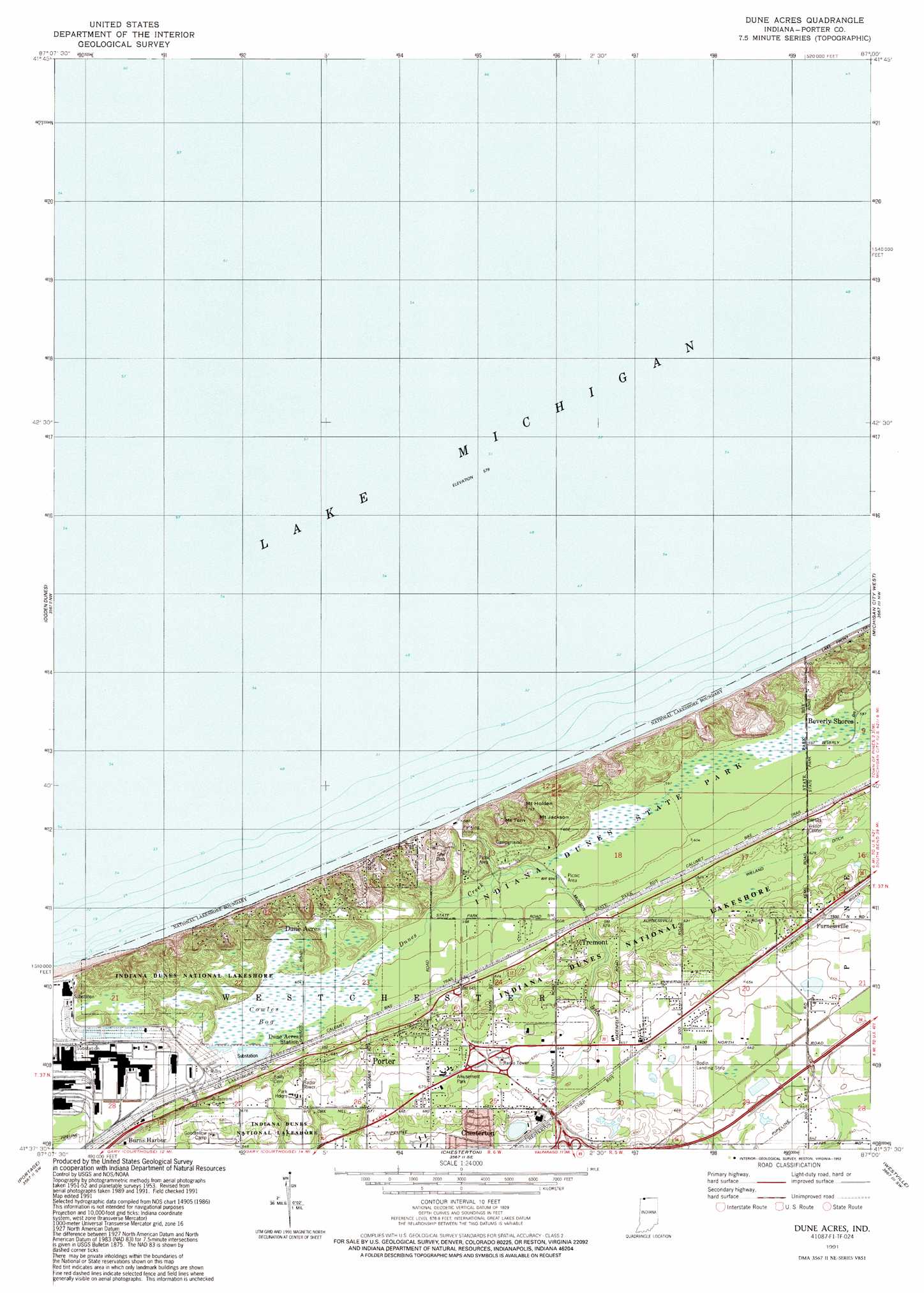
Dune Acres Topo Map Indiana
To zoom in, hover over the map of Dune Acres
USGS Topo Quad 41087f1 - 1:24,000 scale
| Topo Map Name: | Dune Acres |
| USGS Topo Quad ID: | 41087f1 |
| Print Size: | ca. 21 1/4" wide x 27" high |
| Southeast Coordinates: | 41.625° N latitude / 87° W longitude |
| Map Center Coordinates: | 41.6875° N latitude / 87.0625° W longitude |
| U.S. State: | IN |
| Filename: | o41087f1.jpg |
| Download Map JPG Image: | Dune Acres topo map 1:24,000 scale |
| Map Type: | Topographic |
| Topo Series: | 7.5´ |
| Map Scale: | 1:24,000 |
| Source of Map Images: | United States Geological Survey (USGS) |
| Alternate Map Versions: |
Dune Acres IN 1953, updated 1955 Download PDF Buy paper map Dune Acres IN 1953, updated 1961 Download PDF Buy paper map Dune Acres IN 1968, updated 1970 Download PDF Buy paper map Dune Acres IN 1968, updated 1980 Download PDF Buy paper map Dune Acres IN 1991, updated 1992 Download PDF Buy paper map Dune Acres IN 2011 Download PDF Buy paper map Dune Acres IN 2013 Download PDF Buy paper map Dune Acres IN 2016 Download PDF Buy paper map |
1:24,000 Topo Quads surrounding Dune Acres
New Buffalo West |
||||
Ogden Dunes |
Dune Acres |
Michigan City West |
Michigan City East |
|
Gary |
Portage |
Chesterton |
Westville |
Laporte West |
Crown Point |
Palmer |
Valparaiso |
Wanatah |
Hanna |
> Back to 41087e1 at 1:100,000 scale
> Back to 41086a1 at 1:250,000 scale
> Back to U.S. Topo Maps home
Dune Acres topo map: Gazetteer
Dune Acres: Airports
Bodin Landing Strip elevation 202m 662′Dune Acres: Canals
Weiland Ditch elevation 191m 626′Dune Acres: Parks
Indiana Dunes National Lakeshore elevation 201m 659′Indiana Dunes State Park elevation 181m 593′
Dune Acres: Populated Places
Dune Acres elevation 191m 626′Dune Acres Station elevation 187m 613′
Furnessville elevation 201m 659′
Tremont elevation 192m 629′
Dune Acres: Streams
Dunes Creek elevation 189m 620′Dune Acres: Summits
Mount Holden elevation 194m 636′Mount Jackson elevation 192m 629′
Mount Tom elevation 192m 629′
Dune Acres: Swamps
Cowles Bog elevation 185m 606′Dune Acres digital topo map on disk
Buy this Dune Acres topo map showing relief, roads, GPS coordinates and other geographical features, as a high-resolution digital map file on DVD:
Northern Illinois, Northern Indiana & Southwestern Michigan
Buy digital topo maps: Northern Illinois, Northern Indiana & Southwestern Michigan