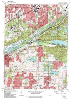
Sag Bridge Topo Map Illinois
To zoom in, hover over the map of Sag Bridge
USGS Topo Quad 41087f8 - 1:24,000 scale
| Topo Map Name: | Sag Bridge |
| USGS Topo Quad ID: | 41087f8 |
| Print Size: | ca. 21 1/4" wide x 27" high |
| Southeast Coordinates: | 41.625° N latitude / 87.875° W longitude |
| Map Center Coordinates: | 41.6875° N latitude / 87.9375° W longitude |
| U.S. State: | IL |
| Filename: | o41087f8.jpg |
| Download Map JPG Image: | Sag Bridge topo map 1:24,000 scale |
| Map Type: | Topographic |
| Topo Series: | 7.5´ |
| Map Scale: | 1:24,000 |
| Source of Map Images: | United States Geological Survey (USGS) |
| Alternate Map Versions: |
Sag Bridge IL 1928 Download PDF Buy paper map Sag Bridge IL 1928, updated 1934 Download PDF Buy paper map Sag Bridge IL 1928, updated 1946 Download PDF Buy paper map Sag Bridge IL 1953, updated 1955 Download PDF Buy paper map Sag Bridge IL 1953, updated 1960 Download PDF Buy paper map Sag Bridge IL 1963, updated 1964 Download PDF Buy paper map Sag Bridge IL 1963, updated 1974 Download PDF Buy paper map Sag Bridge IL 1963, updated 1984 Download PDF Buy paper map Sag Bridge IL 1993, updated 1993 Download PDF Buy paper map Sag Bridge IL 1997, updated 1999 Download PDF Buy paper map Sag Bridge IL 2012 Download PDF Buy paper map Sag Bridge IL 2015 Download PDF Buy paper map |
1:24,000 Topo Quads surrounding Sag Bridge
> Back to 41087e1 at 1:100,000 scale
> Back to 41086a1 at 1:250,000 scale
> Back to U.S. Topo Maps home
Sag Bridge topo map: Gazetteer
Sag Bridge: Airports
Argonne Heliport elevation 220m 721′Brookridge Airport elevation 222m 728′
Midwest Heliport elevation 215m 705′
Sag Bridge: Areas
Mount Forest elevation 209m 685′Sag Bridge: Canals
Chicago Sanitary and Ship Canal elevation 176m 577′Illinois and Michigan Canal elevation 177m 580′
Sag Bridge: Crossings
Interchange 273 elevation 209m 685′Interchange 274 elevation 214m 702′
Sag Bridge: Dams
Bull Frog Lake Dam elevation 204m 669′Dam Number 1 Dam elevation 180m 590′
Dam Number 2 elevation 179m 587′
Dam Number 3 elevation 177m 580′
Dam Number 4 elevation 176m 577′
Dam Number 5 elevation 184m 603′
Dam Number 6 elevation 176m 577′
Dam Number 7 elevation 177m 580′
Holy Family Villa Lake Dam elevation 216m 708′
Maple Lake Dam elevation 198m 649′
Tampier Lake Dam elevation 209m 685′
Sag Bridge: Guts
Longjohn Slough elevation 212m 695′Rainbarrel Slough elevation 206m 675′
Saganashkee Slough elevation 180m 590′
Sag Bridge: Lakes
Joes Pond elevation 203m 666′Tomahawk Slough elevation 209m 685′
Sag Bridge: Parks
Cap Sauers Holdings Nature Preserve elevation 204m 669′Devon Park elevation 211m 692′
Goreham Park elevation 221m 725′
Lindenwood Park elevation 219m 718′
Paw Paw Woods Nature Preserve elevation 187m 613′
Pinewood Park elevation 210m 688′
Sagawau Canyon Nature Preserve elevation 191m 626′
Santa Fe Speedway elevation 189m 620′
Stevens Park elevation 212m 695′
Timberlake Park elevation 214m 702′
Whittaker Park elevation 213m 698′
Yangas Park elevation 207m 679′
Sag Bridge: Populated Places
Anand Brook elevation 207m 679′Burr Ridge elevation 214m 702′
Chickasaw elevation 214m 702′
Country Squire elevation 223m 731′
Creekwood elevation 205m 672′
Dawn Wood elevation 219m 718′
Derby Hills elevation 229m 751′
Derby Meadows elevation 213m 698′
Equestrian Estates elevation 217m 711′
Equestrian Woods elevation 211m 692′
Erin Hills elevation 202m 662′
Fox Chase Estates elevation 217m 711′
Fox Hills elevation 212m 695′
Foxley Acres elevation 202m 662′
Golden Oak Estates elevation 222m 728′
Goodings Grove elevation 231m 757′
Hastings elevation 188m 616′
King Acres elevation 226m 741′
Long Run Acres elevation 218m 715′
Long Run Creek elevation 206m 675′
Maple Leaf Estates elevation 205m 672′
Moorefield Estates elevation 222m 728′
Old Oaks Estates elevation 207m 679′
Palisades elevation 185m 606′
Pheasant Hollow N elevation 218m 715′
Pheasant Hollow S elevation 223m 731′
Quail Brook Estates elevation 218m 715′
Ruffled Feathers Golf Community elevation 219m 718′
Saddle Brook Run elevation 228m 748′
Sag Bridge elevation 190m 623′
Somerset Hills elevation 217m 711′
Spring Creek Woods elevation 210m 688′
Stately Acres elevation 229m 751′
Sylvan Hills elevation 208m 682′
Sylvan Woods elevation 212m 695′
Tedens (historical) elevation 181m 593′
Twin Creek elevation 224m 734′
Sag Bridge: Reservoirs
Bull Frog Lake elevation 204m 669′Holy Family Villa Lake elevation 216m 708′
Mallard Pond elevation 213m 698′
Maple Lake elevation 198m 649′
Saganashkee Slough elevation 179m 587′
Saganashkee Slough elevation 177m 580′
Saganashkee Slough elevation 176m 577′
Saganashkee Slough elevation 184m 603′
Saganashkee Slough elevation 177m 580′
Saganashkee Slough elevation 176m 577′
Saganashkee Slough elevation 180m 590′
Tampier Lake elevation 209m 685′
Tampier Slough elevation 210m 688′
Sag Bridge: Streams
Crooked Creek elevation 180m 590′Flag Creek elevation 179m 587′
Sawmill Creek elevation 180m 590′
Sag Bridge: Swamps
Cramer Slough elevation 213m 698′Horse Collar Slough elevation 210m 688′
Sag Bridge: Trails
Illinois and Michigan Canal State Trail elevation 177m 580′Sag Bridge: Woods
Columbia Woods elevation 181m 593′Henry DeTonty Woods elevation 190m 623′
Paw Paw Woods elevation 181m 593′
Pulaski Woods elevation 209m 685′
Red Gate Woods elevation 196m 643′
Wolf Road Woods elevation 222m 728′
Sag Bridge digital topo map on disk
Buy this Sag Bridge topo map showing relief, roads, GPS coordinates and other geographical features, as a high-resolution digital map file on DVD:
Northern Illinois, Northern Indiana & Southwestern Michigan
Buy digital topo maps: Northern Illinois, Northern Indiana & Southwestern Michigan


