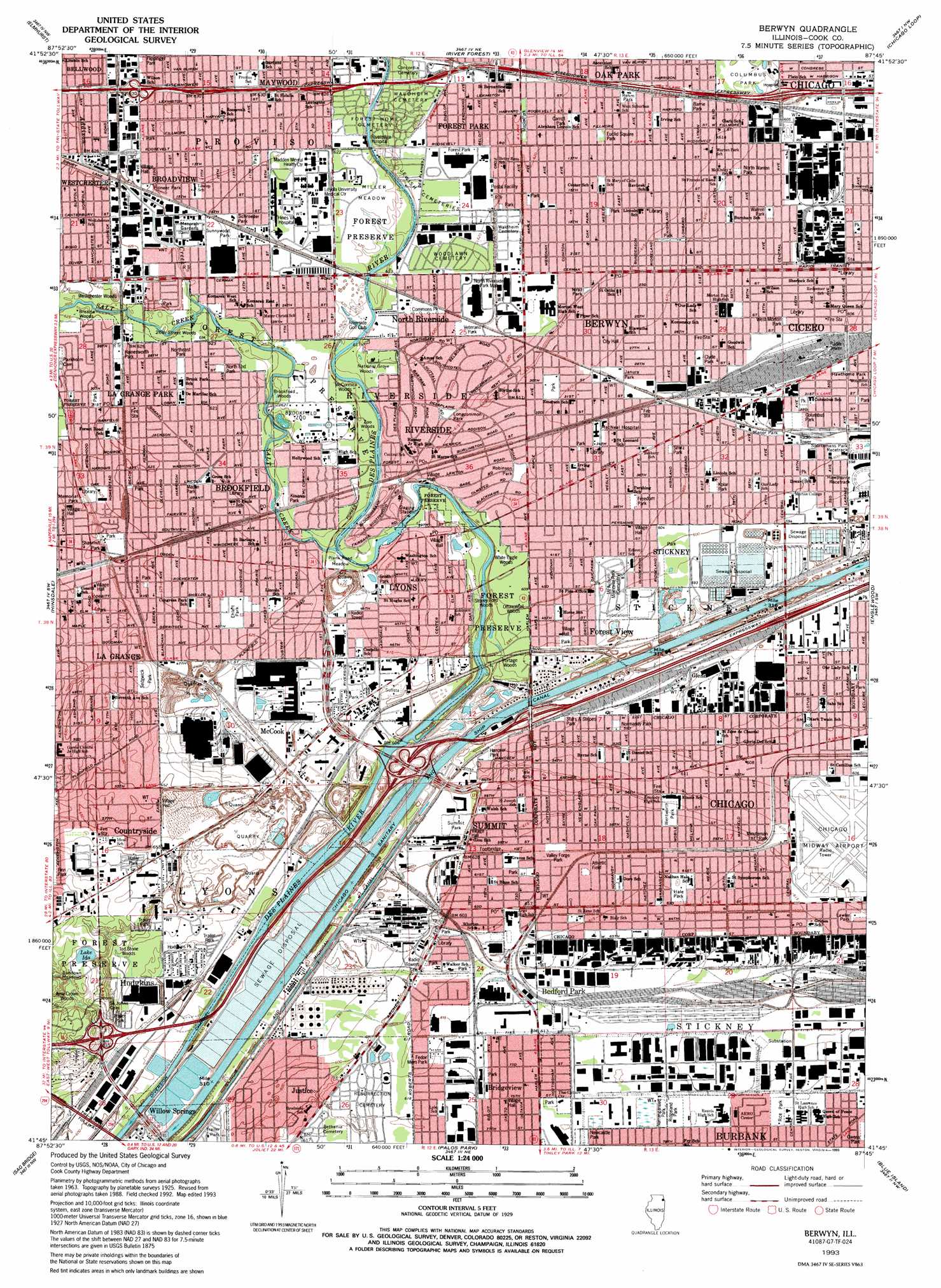
Berwyn Topo Map Illinois
To zoom in, hover over the map of Berwyn
USGS Topo Quad 41087g7 - 1:24,000 scale
| Topo Map Name: | Berwyn |
| USGS Topo Quad ID: | 41087g7 |
| Print Size: | ca. 21 1/4" wide x 27" high |
| Southeast Coordinates: | 41.75° N latitude / 87.75° W longitude |
| Map Center Coordinates: | 41.8125° N latitude / 87.8125° W longitude |
| U.S. State: | IL |
| Filename: | o41087g7.jpg |
| Download Map JPG Image: | Berwyn topo map 1:24,000 scale |
| Map Type: | Topographic |
| Topo Series: | 7.5´ |
| Map Scale: | 1:24,000 |
| Source of Map Images: | United States Geological Survey (USGS) |
| Alternate Map Versions: |
Berwyn IL 1928 Download PDF Buy paper map Berwyn IL 1928, updated 1933 Download PDF Buy paper map Berwyn IL 1928, updated 1945 Download PDF Buy paper map Berwyn IL 1953, updated 1956 Download PDF Buy paper map Berwyn IL 1963, updated 1965 Download PDF Buy paper map Berwyn IL 1963, updated 1973 Download PDF Buy paper map Berwyn IL 1963, updated 1981 Download PDF Buy paper map Berwyn IL 1993, updated 1993 Download PDF Buy paper map Berwyn IL 1993, updated 1993 Download PDF Buy paper map Berwyn IL 1998, updated 2002 Download PDF Buy paper map Berwyn IL 2012 Download PDF Buy paper map Berwyn IL 2015 Download PDF Buy paper map |
1:24,000 Topo Quads surrounding Berwyn
Palatine |
Arlington Heights |
Park Ridge |
Evanston |
|
Lombard |
Elmhurst |
River Forest |
Chicago Loop |
|
Wheaton |
Hinsdale |
Berwyn |
Englewood |
Jackson Park |
Romeoville |
Sag Bridge |
Palos Park |
Blue Island |
Lake Calumet |
Joliet |
Mokena |
Tinley Park |
Harvey |
Calumet City |
> Back to 41087e1 at 1:100,000 scale
> Back to 41086a1 at 1:250,000 scale
> Back to U.S. Topo Maps home
Berwyn topo map: Gazetteer
Berwyn: Airports
86th USARCOM Heliport elevation 189m 620′Chicago Airmail Field (historical) elevation 190m 623′
Chicago Midway Airport elevation 185m 606′
Loyola University Medical Center Heliport elevation 190m 623′
Pielet Summit Heliport elevation 181m 593′
Rose Packing Company Heliport elevation 182m 597′
Berwyn: Canals
Nickerson Ditch (historical) elevation 184m 603′Ogden Ditch (historical) elevation 182m 597′
Berwyn: Crossings
Interchange 18 elevation 187m 613′Interchange 19A elevation 190m 623′
Interchange 19B elevation 183m 600′
Interchange 20 elevation 187m 613′
Interchange 21A elevation 184m 603′
Interchange 21B elevation 188m 616′
Interchange 23A elevation 190m 623′
Interchange 23B elevation 188m 616′
Interchange 24A elevation 183m 600′
Interchange 279 elevation 194m 636′
Interchange 282 elevation 186m 610′
Interchange 283 elevation 186m 610′
Interchange 285 elevation 183m 600′
Laughtons Ford elevation 180m 590′
Riverside Ford elevation 183m 600′
Stony Ford elevation 179m 587′
Summit Ford elevation 182m 597′
Berwyn: Dams
Lyons Dam elevation 186m 610′Ogden Dam (historical) elevation 182m 597′
Berwyn: Flats
Miller Meadow elevation 189m 620′Miller Meadows elevation 189m 620′
Plank Road Meadow elevation 187m 613′
Sundown Meadows elevation 197m 646′
Berwyn: Forests
County Forest Preserve elevation 193m 633′Berwyn: Islands
Prescotts Island elevation 183m 600′Berwyn: Lakes
Lake Ida elevation 197m 646′Berwyn: Mines
Federal Quarry elevation 167m 547′Lyons Quarry elevation 129m 423′
Berwyn: Parks
Barrie Park elevation 190m 623′Berwyn Park elevation 186m 610′
Blythe Park elevation 189m 620′
Brookfield Zoo elevation 189m 620′
Carroll Park elevation 189m 620′
Cermak Park elevation 183m 600′
Chicago Portage National Historic Site elevation 183m 600′
Chicago Zoological Park elevation 189m 620′
Cid Field elevation 181m 593′
Clyde Park elevation 185m 606′
Columbus Park elevation 184m 603′
Columbus Park elevation 188m 616′
Commons Park elevation 190m 623′
Drexel Park elevation 183m 600′
East View Park elevation 195m 639′
Ehlert Park elevation 190m 623′
Euclid Square Park elevation 189m 620′
Fedor Memorial Park elevation 187m 613′
Flippinger Park elevation 193m 633′
Forest Park elevation 188m 616′
Freedom Park elevation 185m 606′
Guthrie Park elevation 188m 616′
Hainesworth Park elevation 191m 626′
Hale Park elevation 187m 613′
Hanover Park elevation 182m 597′
Hawthorne Park elevation 184m 603′
Hodgkins Park elevation 185m 606′
Janura Park elevation 187m 613′
Kiwanis Park elevation 188m 616′
Kolar Park elevation 184m 603′
Lawler Park elevation 189m 620′
Longcommon Park elevation 188m 616′
Madlin Park elevation 190m 623′
Manor Park elevation 184m 603′
Maple Park elevation 189m 620′
Memorial Park elevation 191m 626′
Minuteman Park elevation 186m 610′
Mraz Park elevation 188m 616′
Narragansett Park elevation 189m 620′
Normandy Park elevation 181m 593′
North End Park elevation 189m 620′
North Warren Park elevation 186m 610′
Northeast Park elevation 190m 623′
Parkholme elevation 184m 603′
Pioneer Park elevation 190m 623′
Rehm Park elevation 190m 623′
Rice Park elevation 189m 620′
Ridgeland Park elevation 189m 620′
Robin Hood Park elevation 191m 626′
Robinson Park elevation 186m 610′
Roosevelt Park elevation 189m 620′
Santa Fe Prairie Nature Preserve elevation 180m 590′
Schroeder Park elevation 190m 623′
Sedgwick Park elevation 195m 639′
Shawmut Park elevation 192m 629′
Smirz Park elevation 185m 606′
Smith Park elevation 189m 620′
Stars and Stripes Park elevation 182m 597′
Summit Park elevation 182m 597′
Sunnywood Park elevation 190m 623′
Valley Forge Park elevation 188m 616′
Veterans Park elevation 189m 620′
Warren Park elevation 185m 606′
Wentworth Park elevation 187m 613′
West Morton Park elevation 185m 606′
Berwyn: Populated Places
Bedford Park elevation 188m 616′Berwyn elevation 188m 616′
Bridgeview elevation 189m 620′
Broadview elevation 192m 629′
Brookfield elevation 190m 623′
Cicero elevation 184m 603′
Clearing elevation 187m 613′
Clearing elevation 187m 613′
Clyde elevation 185m 606′
East Grossdale elevation 189m 620′
Forest View elevation 181m 593′
Gary elevation 184m 603′
Glenn elevation 182m 597′
Hines elevation 190m 623′
Hodgkins elevation 184m 603′
La Grange elevation 197m 646′
La Grange Park elevation 190m 623′
Lavergne elevation 190m 623′
Lyons elevation 189m 620′
McCook elevation 188m 616′
North Riverside elevation 188m 616′
Riverside elevation 188m 616′
Stickney elevation 184m 603′
Summit elevation 187m 613′
Berwyn: Post Offices
Berwyn Post Office elevation 187m 613′Broadview Post Office elevation 191m 626′
Brookfield Post Office elevation 188m 616′
Cicero Post Office elevation 184m 603′
La Grange Park Branch Post Office elevation 190m 623′
La Grange Post Office elevation 195m 639′
Lyons Post Office elevation 185m 606′
Riverside Post Office elevation 188m 616′
Summit Argo Post Office elevation 186m 610′
Berwyn: Streams
Addison Creek elevation 187m 613′Portage Creek elevation 182m 597′
Salt Creek elevation 185m 606′
Berwyn: Woods
Airie Crown Woods elevation 196m 643′Brezina Woods elevation 190m 623′
Brookfield Woods elevation 188m 616′
Chicago Portage Woods elevation 182m 597′
McCormick Woods elevation 188m 616′
National Grove Woods elevation 187m 613′
Ottawa Trail Woods North elevation 185m 606′
Ottawa Trail Woods South elevation 182m 597′
Portage Woods elevation 182m 597′
Schuths Grove elevation 189m 620′
Stoney Ford Woods elevation 179m 587′
Ted Stone Woods elevation 188m 616′
Twentysix Street Woods elevation 188m 616′
Westchester Woods elevation 190m 623′
White Eagle Woods North elevation 184m 603′
White Eagle Woods South elevation 185m 606′
Zoo Woods elevation 187m 613′
Berwyn digital topo map on disk
Buy this Berwyn topo map showing relief, roads, GPS coordinates and other geographical features, as a high-resolution digital map file on DVD:
Northern Illinois, Northern Indiana & Southwestern Michigan
Buy digital topo maps: Northern Illinois, Northern Indiana & Southwestern Michigan