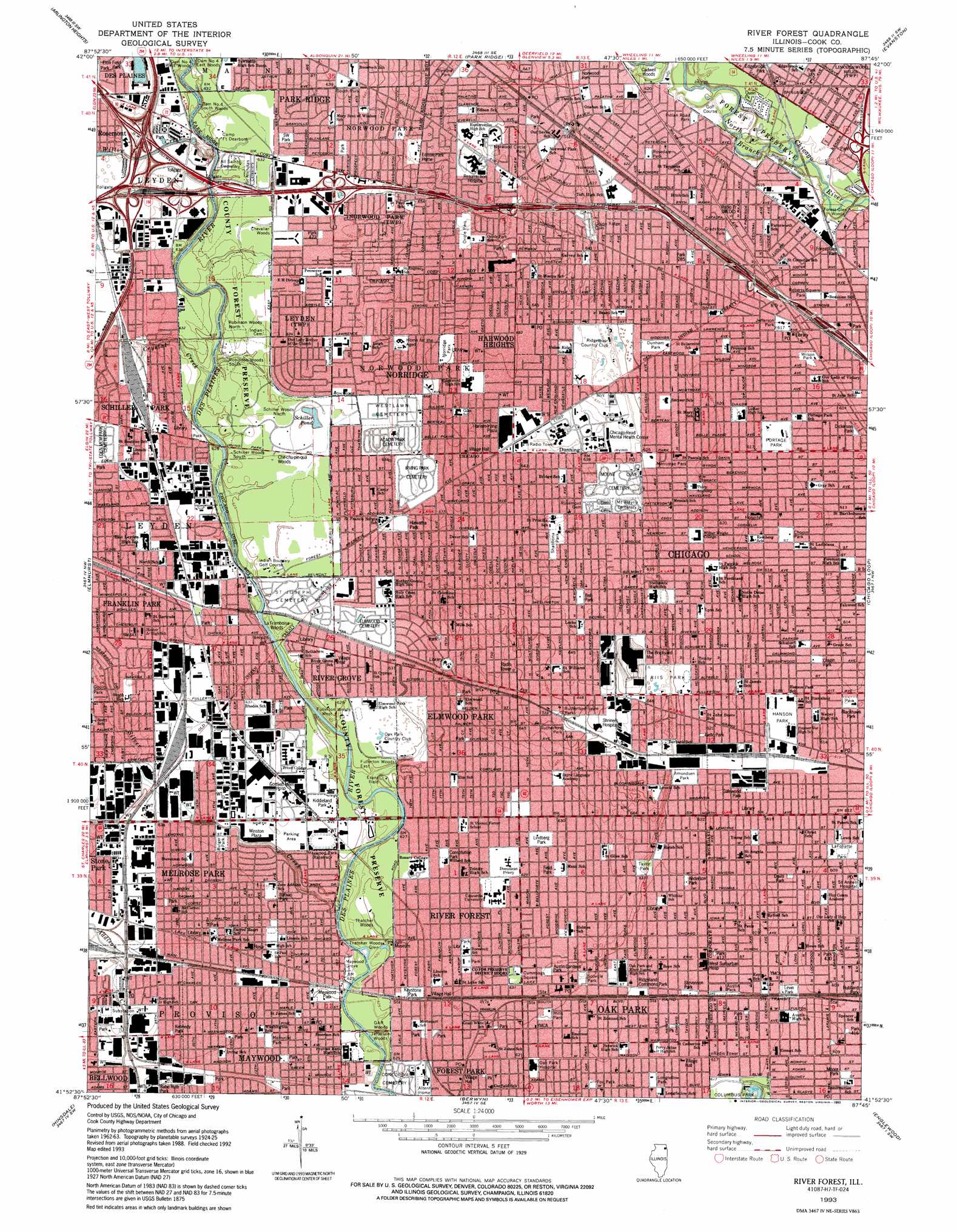
River Forest Topo Map Illinois
To zoom in, hover over the map of River Forest
USGS Topo Quad 41087h7 - 1:24,000 scale
| Topo Map Name: | River Forest |
| USGS Topo Quad ID: | 41087h7 |
| Print Size: | ca. 21 1/4" wide x 27" high |
| Southeast Coordinates: | 41.875° N latitude / 87.75° W longitude |
| Map Center Coordinates: | 41.9375° N latitude / 87.8125° W longitude |
| U.S. State: | IL |
| Filename: | o41087h7.jpg |
| Download Map JPG Image: | River Forest topo map 1:24,000 scale |
| Map Type: | Topographic |
| Topo Series: | 7.5´ |
| Map Scale: | 1:24,000 |
| Source of Map Images: | United States Geological Survey (USGS) |
| Alternate Map Versions: |
River Forest IL 1928 Download PDF Buy paper map River Forest IL 1928 Download PDF Buy paper map River Forest IL 1928, updated 1948 Download PDF Buy paper map River Forest IL 1928, updated 1950 Download PDF Buy paper map River Forest IL 1953, updated 1955 Download PDF Buy paper map River Forest IL 1963, updated 1964 Download PDF Buy paper map River Forest IL 1963, updated 1973 Download PDF Buy paper map River Forest IL 1963, updated 1982 Download PDF Buy paper map River Forest IL 1963, updated 1989 Download PDF Buy paper map River Forest IL 1993, updated 1993 Download PDF Buy paper map River Forest IL 1993, updated 1993 Download PDF Buy paper map River Forest IL 1997, updated 1999 Download PDF Buy paper map River Forest IL 2012 Download PDF Buy paper map River Forest IL 2015 Download PDF Buy paper map |
1:24,000 Topo Quads surrounding River Forest
Lake Zurich |
Wheeling |
Highland Park |
||
Palatine |
Arlington Heights |
Park Ridge |
Evanston |
|
Lombard |
Elmhurst |
River Forest |
Chicago Loop |
|
Wheaton |
Hinsdale |
Berwyn |
Englewood |
Jackson Park |
Romeoville |
Sag Bridge |
Palos Park |
Blue Island |
Lake Calumet |
> Back to 41087e1 at 1:100,000 scale
> Back to 41086a1 at 1:250,000 scale
> Back to U.S. Topo Maps home
River Forest topo map: Gazetteer
River Forest: Airports
B and L Heliport elevation 193m 633′Matsushita Electric Corp of America Heliport elevation 195m 639′
Sauerman Heliport elevation 196m 643′
River Forest: Crossings
Interchange 2 elevation 193m 633′Interchange 41A-B elevation 185m 606′
Interchange 78 elevation 193m 633′
Interchange 79 elevation 197m 646′
Interchange 80 elevation 192m 629′
Interchange 81A elevation 193m 633′
Interchange 81B elevation 190m 623′
Interchange 82A elevation 183m 600′
Interchange 82B elevation 189m 620′
Interchange 83A elevation 183m 600′
Interchange 83B elevation 182m 597′
Interchange 84 elevation 181m 593′
River Forest: Dams
Dam Number 4 North elevation 186m 610′River Forest: Lakes
Schiller Pond elevation 190m 623′River Forest: Parks
Aiello Park elevation 191m 626′Amundsen Park elevation 192m 629′
Anderson Park elevation 189m 620′
Austin Gardens Park elevation 192m 629′
Austin Park elevation 189m 620′
Austin Town Hall Park elevation 189m 620′
Babe Ruth Park elevation 192m 629′
Bataan Park elevation 192m 629′
Bell Park elevation 195m 639′
Blackhawk Park elevation 189m 620′
Brickton Park elevation 194m 636′
Bulger Park elevation 192m 629′
Chopin Park elevation 188m 616′
Constitution Park elevation 189m 620′
Cragin Park elevation 188m 616′
Cummings Square elevation 193m 633′
Davis Park elevation 188m 616′
DeJulio Playlot elevation 186m 610′
Dickinson Park elevation 187m 613′
Dunham Park elevation 190m 623′
Edgebrook Park elevation 189m 620′
Emmett Whealan Swimming Pool (historical) elevation 188m 616′
Eton Park elevation 194m 636′
Evans Field elevation 191m 626′
Field Park elevation 194m 636′
Field Park elevation 192m 629′
Forest Glen Park elevation 186m 610′
Fox Park elevation 189m 620′
Galewood Park elevation 189m 620′
Gladstone Park elevation 189m 620′
Greenfields Park elevation 192m 629′
Hanson Park elevation 188m 616′
Hiawatha Park elevation 192m 629′
Hubbard Park elevation 185m 606′
Indian Road Park elevation 189m 620′
Jaycee Park elevation 200m 656′
Jefferson Park elevation 186m 610′
Kathy Torpe Park elevation 193m 633′
Kennedy Park elevation 192m 629′
Keystone Park elevation 196m 643′
Kiddie Korale Park elevation 191m 626′
Kiddieland Park elevation 192m 629′
Kinzie Parkway Park elevation 187m 613′
LaFollette Park elevation 186m 610′
Levin Park elevation 187m 613′
Lindberg Park elevation 192m 629′
Longfellow Park elevation 188m 616′
Maywood Park elevation 190m 623′
Memorial Park elevation 191m 626′
Merrick Park elevation 187m 613′
Merrimac Park elevation 190m 623′
Mills Park elevation 191m 626′
Mills Park elevation 195m 639′
Moore Park elevation 185m 606′
Norridge Park elevation 198m 649′
Norwood Circle Park elevation 198m 649′
Norwood Park elevation 191m 626′
Norwood Playground elevation 190m 623′
Oak Park Swimming Pool elevation 190m 623′
Olympia Park elevation 200m 656′
Oriole Park elevation 200m 656′
Park 285 elevation 189m 620′
Park 335 elevation 187m 613′
Park 413 elevation 188m 616′
Park 416 elevation 186m 610′
Park 430 elevation 186m 610′
Portage Park elevation 188m 616′
Quinn Park elevation 186m 610′
Ridgeland Commons Park elevation 190m 623′
Ridgeland Park elevation 190m 623′
Riis Park elevation 197m 646′
Roberts Square Park elevation 187m 613′
Rosedale Park elevation 190m 623′
Rutherford Park elevation 198m 649′
Rutherford-Sayre Park elevation 198m 649′
S W Park elevation 193m 633′
Sauganash Reserve elevation 188m 616′
Sayre Park elevation 198m 649′
Scoville Park elevation 193m 633′
Seymour Simon Preserve elevation 191m 626′
Shabbona Park elevation 195m 639′
South Park elevation 195m 639′
Stevenson Park elevation 192m 629′
Stevenson Park elevation 189m 620′
Stevenson Playground elevation 190m 623′
Taylor Park elevation 193m 633′
Thatcher Woods Glen elevation 185m 606′
Triangle Park elevation 192m 629′
Wilson Park elevation 188m 616′
River Forest: Populated Places
Austin elevation 189m 620′Belmont Cragin elevation 189m 620′
Belmont Park elevation 187m 613′
Colonial Gardens elevation 189m 620′
Cragin elevation 187m 613′
Dunning elevation 194m 636′
Edgebrook elevation 189m 620′
Edison elevation 202m 662′
Edmund F Burton Row Houses elevation 190m 623′
Ellsworth elevation 196m 643′
Elmwood Park elevation 196m 643′
Forest Park elevation 190m 623′
Franklin Park elevation 196m 643′
Galewood elevation 197m 646′
Gladstone elevation 189m 620′
Hanson Park elevation 189m 620′
Harwood Heights elevation 198m 649′
Jefferson Park elevation 184m 603′
Martin Luther elevation 189m 620′
Maywood elevation 191m 626′
Melrose Park elevation 193m 633′
Montclare elevation 198m 649′
Norridge elevation 195m 639′
Oak Park elevation 189m 620′
Portage Park elevation 188m 616′
Ridgeland elevation 190m 623′
River Forest elevation 192m 629′
River Grove elevation 191m 626′
Riverview elevation 196m 643′
Samuel A Rothermel Houses elevation 191m 626′
Schiller Park elevation 195m 639′
Schorsch elevation 190m 623′
Western Dunning elevation 195m 639′
Whiskey Point elevation 187m 613′
River Forest: Post Offices
Edgebrook Station Chicago Post Office elevation 189m 620′Elmwood Park Post Office elevation 197m 646′
Forest Park Post Office elevation 191m 626′
Franklin Park Post Office elevation 197m 646′
Harwood Heights Post Office elevation 197m 646′
Maywood Post Office elevation 190m 623′
Oak Park Post Office elevation 192m 629′
River Grove Post Office elevation 192m 629′
River Forest: Reservoirs
Peterson Lake elevation 190m 623′River Forest: Streams
Crystal Creek elevation 187m 613′Silver Creek elevation 186m 610′
Willow Creek elevation 187m 613′
River Forest: Summits
Players Hill elevation 187m 613′River Forest: Woods
C F Smith Woods elevation 185m 606′Cadwell Woods elevation 185m 606′
Che-chu-pin-qua Woods elevation 192m 629′
Chevalier Woods elevation 192m 629′
Dam Number 4 South Woods elevation 190m 623′
Dam Number 4 West Woods elevation 190m 623′
Edgebrook Woods elevation 188m 616′
Forest Glen Woods elevation 181m 593′
Fullerton Woods East elevation 190m 623′
Fullerton Woods West elevation 191m 626′
GAR Woods elevation 187m 613′
Indian Road Woods elevation 185m 606′
Jefferson Woods elevation 188m 616′
LaFramboise Woods elevation 190m 623′
Maywood Grove elevation 186m 610′
Myrtle Grove elevation 197m 646′
Robinson Woods North elevation 193m 633′
Robinson Woods South elevation 191m 626′
Schiller Woods North elevation 192m 629′
Schiller Woods South elevation 191m 626′
Thatcher Woods elevation 187m 613′
River Forest digital topo map on disk
Buy this River Forest topo map showing relief, roads, GPS coordinates and other geographical features, as a high-resolution digital map file on DVD:
Northern Illinois, Northern Indiana & Southwestern Michigan
Buy digital topo maps: Northern Illinois, Northern Indiana & Southwestern Michigan