Wilmington Topo Map Illinois
To zoom in, hover over the map of Wilmington
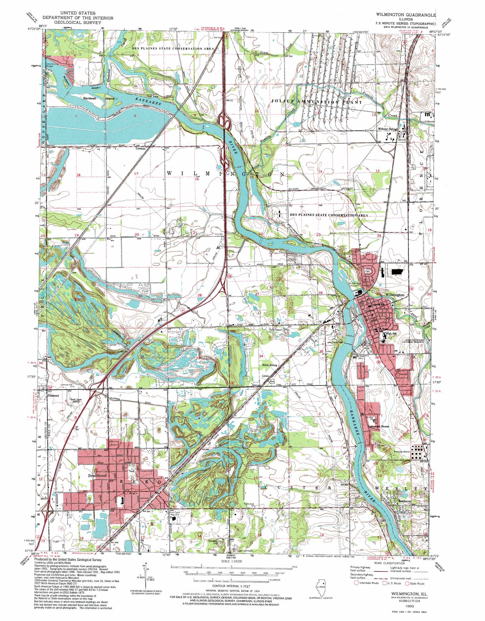
USGS Topo Quad 41088c2 - 1:24,000 scale
| Topo Map Name: | Wilmington |
| USGS Topo Quad ID: | 41088c2 |
| Print Size: | ca. 21 1/4" wide x 27" high |
| Southeast Coordinates: | 41.25° N latitude / 88.125° W longitude |
| Map Center Coordinates: | 41.3125° N latitude / 88.1875° W longitude |
| U.S. State: | IL |
| Filename: | o41088c2.jpg |
| Download Map JPG Image: | Wilmington topo map 1:24,000 scale |
| Map Type: | Topographic |
| Topo Series: | 7.5´ |
| Map Scale: | 1:24,000 |
| Source of Map Images: | United States Geological Survey (USGS) |
| Alternate Map Versions: |
Wilmington IL 1954, updated 1955 Download PDF Buy paper map Wilmington IL 1954, updated 1970 Download PDF Buy paper map Wilmington IL 1954, updated 1974 Download PDF Buy paper map Wilmington IL 1954, updated 1984 Download PDF Buy paper map Wilmington IL 1993, updated 1994 Download PDF Buy paper map Wilmington IL 1999, updated 2002 Download PDF Buy paper map Wilmington IL 2012 Download PDF Buy paper map Wilmington IL 2015 Download PDF Buy paper map |
| FStopo: | US Forest Service topo Wilmington is available: Download FStopo PDF Download FStopo TIF |
1:24,000 Topo Quads surrounding Wilmington
Plattville |
Yorkville Se |
Plainfield |
Joliet |
Mokena |
Lisbon |
Minooka |
Channahon |
Elwood |
Manhattan |
Morris |
Coal City |
Wilmington |
Symerton |
Wilton Center |
Mazon |
Gardner |
Essex |
Bonfield |
Bourbonnais |
Dwight |
Campus |
Buckingham |
Herscher |
West Kankakee |
> Back to 41088a1 at 1:100,000 scale
> Back to 41088a1 at 1:250,000 scale
> Back to U.S. Topo Maps home
Wilmington topo map: Gazetteer
Wilmington: Bridges
County Line Bridge elevation 153m 501′Wilmington: Crossings
Interchange 233 elevation 177m 580′Interchange 236 elevation 170m 557′
Interchange 238 elevation 172m 564′
Interchange 240 elevation 163m 534′
Interchange 241 elevation 160m 524′
Wilmington: Dams
Spillway 531 elevation 161m 528′Wilmington: Islands
Bardwell Island elevation 155m 508′Grape Island elevation 153m 501′
Mulberry Island elevation 155m 508′
Wilmington: Lakes
Milliken Lake elevation 168m 551′Wilmington: Mines
A Mine elevation 176m 577′Bardwell Mine elevation 159m 521′
C Mine elevation 172m 564′
Co-Operative Mine elevation 173m 567′
D Mine elevation 168m 551′
E Mine elevation 174m 570′
Eureka Number 1 Mine elevation 176m 577′
Eureka Number 2 Mine elevation 176m 577′
F Mine elevation 169m 554′
G Mine elevation 173m 567′
Haskett Mine elevation 174m 570′
Hunter Mine elevation 170m 557′
I Mine elevation 170m 557′
J Mine elevation 170m 557′
L Mine elevation 169m 554′
Matlby Mine elevation 169m 554′
Murphy And Keenan Number 3 Mine elevation 169m 554′
Murphy, Linskey And Kasher Number 4 Mine elevation 170m 557′
N Mine elevation 169m 554′
O Mine elevation 174m 570′
Oswald And Young Mine elevation 169m 554′
Pit 1 Northern Mine elevation 166m 544′
Pit 1A Northern Mine elevation 169m 554′
Pit 1B Northern Mine elevation 164m 538′
Pit 1C Northern Mine elevation 165m 541′
Pit 2 Northern Mine elevation 169m 554′
Pit 3 Northern Mine elevation 172m 564′
Pit 4 Northern Mine elevation 177m 580′
Pit 5 Northern Mine elevation 178m 583′
Schoonmaker Mine elevation 159m 521′
Skinner Number 2 Mine elevation 169m 554′
Will Mine elevation 168m 551′
Wilmington Mine elevation 171m 561′
Wilmington Number 2 Mine elevation 180m 590′
Wilmington: Parks
Braidwood City Park elevation 172m 564′Braidwood Dunes and Savanna Nature Preserve elevation 183m 600′
Forsythe Woods County Forest Preserve elevation 166m 544′
Grant Creek Prairie Nature Preserve elevation 160m 524′
Hitts Siding Prairie Nature Preserve elevation 172m 564′
Island Park elevation 164m 538′
Midewin National Tallgrass Prairie elevation 195m 639′
Sand Ridge Savanna Nature Preserve elevation 179m 587′
Wilmington Shrub Prairie Nature Preserve elevation 170m 557′
Wilmington: Populated Places
Braidwood elevation 176m 577′Lakewood Shores elevation 172m 564′
Lorenzo elevation 163m 534′
Resthaven elevation 171m 561′
Riverwood Estates elevation 169m 554′
Wilmington elevation 166m 544′
Winchester Estates elevation 169m 554′
Wilmington: Post Offices
Braidwood Post Office elevation 175m 574′Wilmington Post Office elevation 165m 541′
Wilmington: Reservoirs
Big Shadow Lake elevation 168m 551′Dinosaur Lake elevation 168m 551′
Hawk Lake elevation 168m 551′
Little Shadow Lake elevation 168m 551′
Third Shadow Lake elevation 168m 551′
Wilmington: Streams
Forked Creek elevation 161m 528′Jordan Creek elevation 164m 538′
Prairie Creek elevation 157m 515′
Wilmington digital topo map on disk
Buy this Wilmington topo map showing relief, roads, GPS coordinates and other geographical features, as a high-resolution digital map file on DVD:
Northern Illinois, Northern Indiana & Southwestern Michigan
Buy digital topo maps: Northern Illinois, Northern Indiana & Southwestern Michigan