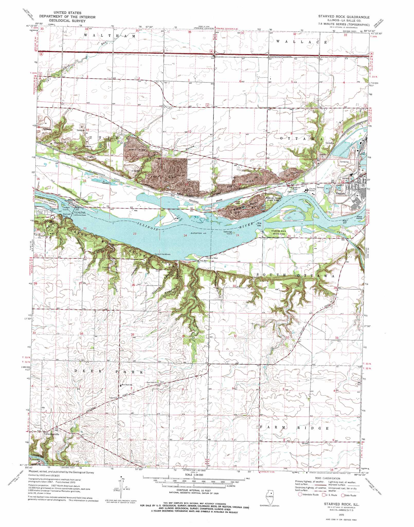
Starved Rock Topo Map Illinois
To zoom in, hover over the map of Starved Rock
USGS Topo Quad 41088c8 - 1:24,000 scale
| Topo Map Name: | Starved Rock |
| USGS Topo Quad ID: | 41088c8 |
| Print Size: | ca. 21 1/4" wide x 27" high |
| Southeast Coordinates: | 41.25° N latitude / 88.875° W longitude |
| Map Center Coordinates: | 41.3125° N latitude / 88.9375° W longitude |
| U.S. State: | IL |
| Filename: | o41088c8.jpg |
| Download Map JPG Image: | Starved Rock topo map 1:24,000 scale |
| Map Type: | Topographic |
| Topo Series: | 7.5´ |
| Map Scale: | 1:24,000 |
| Source of Map Images: | United States Geological Survey (USGS) |
| Alternate Map Versions: |
Starved Rock IL 1970, updated 1972 Download PDF Buy paper map Starved Rock IL 1970, updated 1975 Download PDF Buy paper map Starved Rock IL 1970, updated 1975 Download PDF Buy paper map Starved Rock IL 2012 Download PDF Buy paper map Starved Rock IL 2015 Download PDF Buy paper map |
1:24,000 Topo Quads surrounding Starved Rock
Mendota West |
Mendota East |
Earlville |
Leland |
Sheridan |
Ladd |
Troy Grove |
Prairie Center |
Wedron |
Serena |
Spring Valley |
La Salle |
Starved Rock |
Ottawa |
Marseilles |
Mcnabb |
Tonica |
Leonore |
Streator North |
Ransom |
Varna |
Wenona |
Long Point |
Streator South |
Blackstone |
> Back to 41088a1 at 1:100,000 scale
> Back to 41088a1 at 1:250,000 scale
> Back to U.S. Topo Maps home
Starved Rock topo map: Gazetteer
Starved Rock: Airports
Starved Rock Airpark elevation 139m 456′Starved Rock: Bends
Horseshoe Bend elevation 140m 459′Starved Rock: Dams
Lock Number 12 (historical) elevation 144m 472′Starved Rock Lock and Dam elevation 140m 459′
Starved Rock: Flats
Parkmans Plain elevation 185m 606′Starved Rock: Islands
Delbridge Island elevation 140m 459′Leopold Island elevation 139m 456′
Plum Island elevation 138m 452′
Sheehan Island elevation 142m 465′
Starved Rock: Mines
Buffalo Rock Mine (historical) elevation 169m 554′Osage Mine (historical) elevation 164m 538′
Utica Quarry elevation 170m 557′
Starved Rock: Parks
Buffalo Rock State Park elevation 166m 544′Starved Rock State Park elevation 170m 557′
Starved Rock: Populated Places
Naplate elevation 147m 482′Vermilionville elevation 196m 643′
Starved Rock: Reservoirs
Starved Rock Pool elevation 140m 459′Starved Rock: Streams
Clark Run elevation 138m 452′Covel Creek elevation 140m 459′
Starved Rock: Summits
Buffalo Rock elevation 169m 554′Starved Rock elevation 167m 547′
Starved Rock: Valleys
Aurora Canyon elevation 143m 469′French Canyon elevation 137m 449′
Hennepin Canyon elevation 141m 462′
Higbee Ravine elevation 156m 511′
Horseshoe Canyon elevation 153m 501′
Illinois Canyon elevation 143m 469′
Kaskaskia Canyon elevation 141m 462′
LaSalle Canyon elevation 142m 465′
Ottawa Canyon elevation 150m 492′
Owl Canyon elevation 163m 534′
Tonti Canyon elevation 142m 465′
Wildcat Canyon elevation 142m 465′
Starved Rock digital topo map on disk
Buy this Starved Rock topo map showing relief, roads, GPS coordinates and other geographical features, as a high-resolution digital map file on DVD:
Northern Illinois, Northern Indiana & Southwestern Michigan
Buy digital topo maps: Northern Illinois, Northern Indiana & Southwestern Michigan