Channahon Topo Map Illinois
To zoom in, hover over the map of Channahon
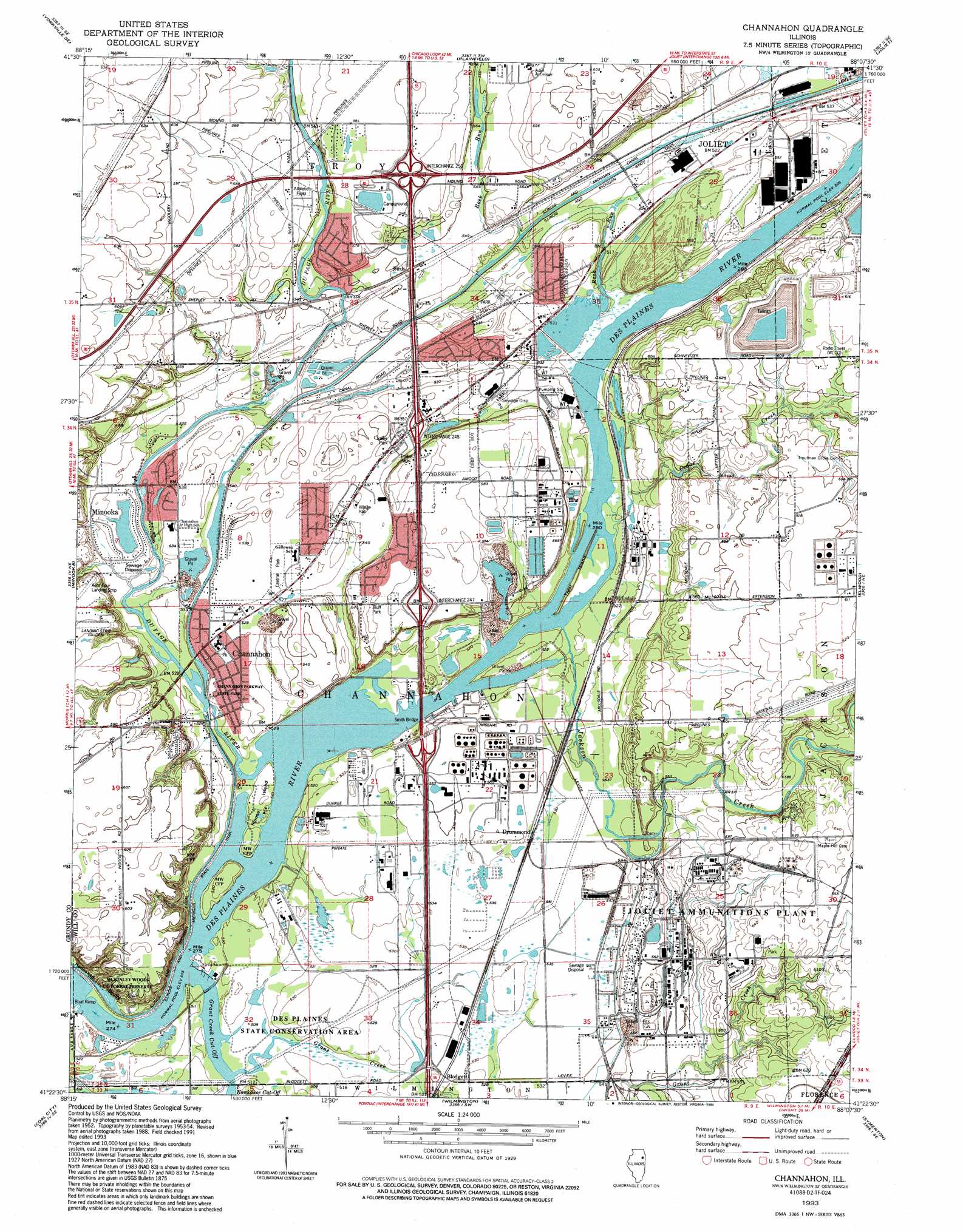
USGS Topo Quad 41088d2 - 1:24,000 scale
| Topo Map Name: | Channahon |
| USGS Topo Quad ID: | 41088d2 |
| Print Size: | ca. 21 1/4" wide x 27" high |
| Southeast Coordinates: | 41.375° N latitude / 88.125° W longitude |
| Map Center Coordinates: | 41.4375° N latitude / 88.1875° W longitude |
| U.S. State: | IL |
| Filename: | o41088d2.jpg |
| Download Map JPG Image: | Channahon topo map 1:24,000 scale |
| Map Type: | Topographic |
| Topo Series: | 7.5´ |
| Map Scale: | 1:24,000 |
| Source of Map Images: | United States Geological Survey (USGS) |
| Alternate Map Versions: |
Channahon IL 1954, updated 1955 Download PDF Buy paper map Channahon IL 1954, updated 1966 Download PDF Buy paper map Channahon IL 1954, updated 1974 Download PDF Buy paper map Channahon IL 1954, updated 1979 Download PDF Buy paper map Channahon IL 1993, updated 1994 Download PDF Buy paper map Channahon IL 1999, updated 2002 Download PDF Buy paper map Channahon IL 2012 Download PDF Buy paper map Channahon IL 2015 Download PDF Buy paper map |
| FStopo: | US Forest Service topo Channahon is available: Download FStopo PDF Download FStopo TIF |
1:24,000 Topo Quads surrounding Channahon
Yorkville |
Aurora South |
Normantown |
Romeoville |
Sag Bridge |
Plattville |
Yorkville Se |
Plainfield |
Joliet |
Mokena |
Lisbon |
Minooka |
Channahon |
Elwood |
Manhattan |
Morris |
Coal City |
Wilmington |
Symerton |
Wilton Center |
Mazon |
Gardner |
Essex |
Bonfield |
Bourbonnais |
> Back to 41088a1 at 1:100,000 scale
> Back to 41088a1 at 1:250,000 scale
> Back to U.S. Topo Maps home
Channahon topo map: Gazetteer
Channahon: Airports
Aero Four Airport elevation 178m 583′Chicago Glider Club Gliderport elevation 180m 590′
Haley Field elevation 179m 587′
M G T Channahon Illinois Heliport elevation 181m 593′
Channahon: Bridges
Smith Bridge elevation 153m 501′Channahon: Canals
Dupage Feeder (historical) elevation 159m 521′Channahon: Crossings
Interchange 245 elevation 167m 547′Interchange 247 elevation 180m 590′
Interchange 248 elevation 166m 544′
Interchange 250 elevation 183m 600′
Channahon: Dams
Lock Number 6 elevation 157m 515′Lock Number 7 elevation 155m 508′
Channahon: Islands
Conroy Island elevation 157m 515′Moose Island elevation 159m 521′
Treat Island elevation 154m 505′
Channahon: Lakes
Minooka Widewater (historical) elevation 159m 521′Channahon: Parks
Bluff Park elevation 171m 561′Central Park elevation 162m 531′
Channahon Parkway State Park elevation 157m 515′
Des Plaines State Conservation Area elevation 159m 521′
McKinley Woods County Forest Preserve elevation 168m 551′
Channahon: Populated Places
Birds elevation 177m 580′Blodgett elevation 158m 518′
Channahon elevation 162m 531′
Drummond elevation 162m 531′
Lake of the Woods elevation 178m 583′
Millsdale elevation 159m 521′
Oak Lane elevation 173m 567′
Rock Run Park elevation 164m 538′
Channahon: Post Offices
Channahon Post Office elevation 161m 528′Channahon: Reservoirs
Frontage Road Pond elevation 156m 511′Channahon: Streams
Cedar Creek elevation 154m 505′Du Page River elevation 153m 501′
Grant Creek elevation 153m 501′
Grant Creek Cut-Off elevation 154m 505′
Jackson Creek elevation 154m 505′
Kankakee Cut-Off elevation 154m 505′
Rock Run elevation 161m 528′
Channahon digital topo map on disk
Buy this Channahon topo map showing relief, roads, GPS coordinates and other geographical features, as a high-resolution digital map file on DVD:
Northern Illinois, Northern Indiana & Southwestern Michigan
Buy digital topo maps: Northern Illinois, Northern Indiana & Southwestern Michigan