Naperville Topo Map Illinois
To zoom in, hover over the map of Naperville
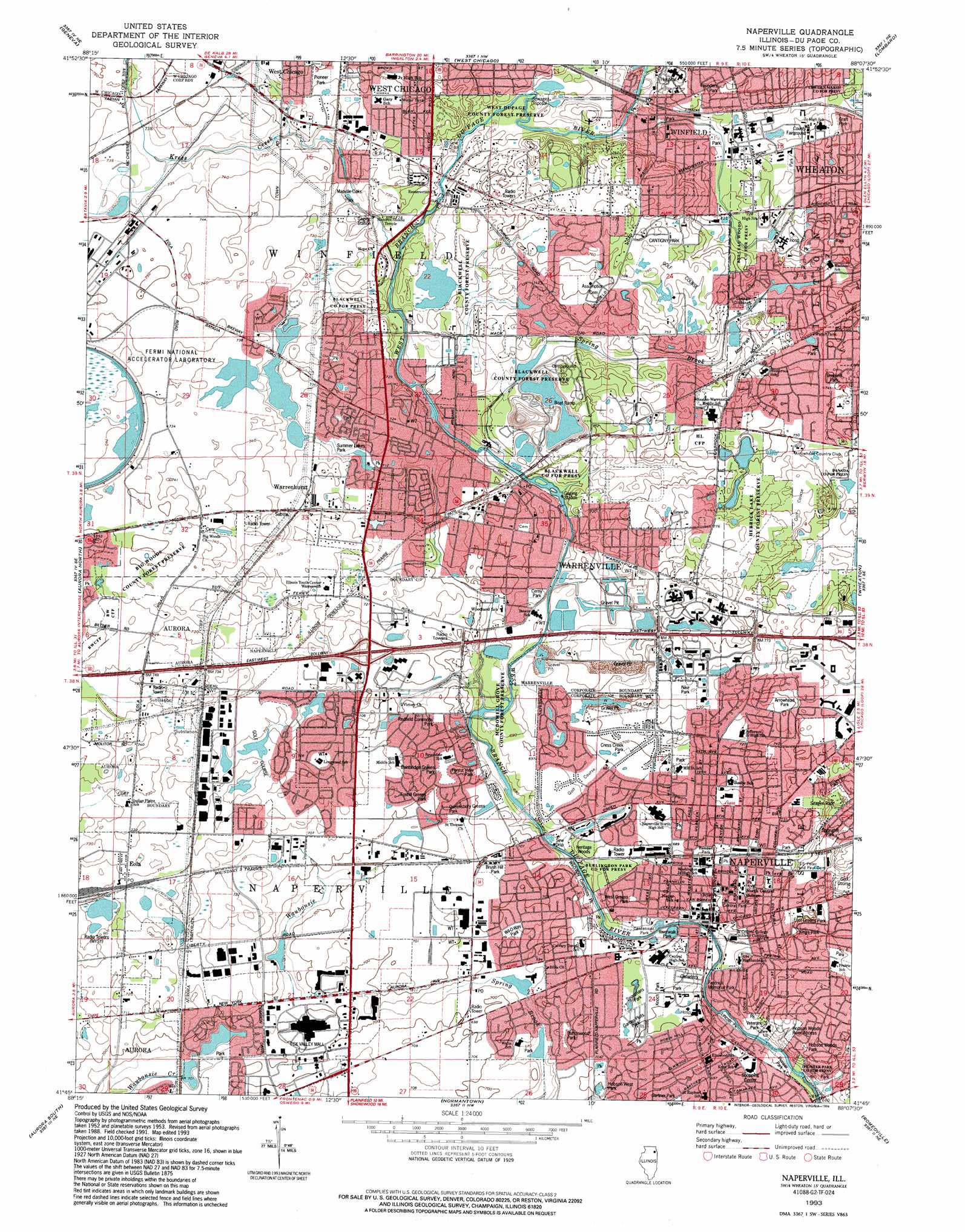
USGS Topo Quad 41088g2 - 1:24,000 scale
| Topo Map Name: | Naperville |
| USGS Topo Quad ID: | 41088g2 |
| Print Size: | ca. 21 1/4" wide x 27" high |
| Southeast Coordinates: | 41.75° N latitude / 88.125° W longitude |
| Map Center Coordinates: | 41.8125° N latitude / 88.1875° W longitude |
| U.S. State: | IL |
| Filename: | o41088g2.jpg |
| Download Map JPG Image: | Naperville topo map 1:24,000 scale |
| Map Type: | Topographic |
| Topo Series: | 7.5´ |
| Map Scale: | 1:24,000 |
| Source of Map Images: | United States Geological Survey (USGS) |
| Alternate Map Versions: |
Naperville IL 1953, updated 1955 Download PDF Buy paper map Naperville IL 1962, updated 1964 Download PDF Buy paper map Naperville IL 1962, updated 1973 Download PDF Buy paper map Naperville IL 1962, updated 1981 Download PDF Buy paper map Naperville IL 1962, updated 1987 Download PDF Buy paper map Naperville IL 1993, updated 1994 Download PDF Buy paper map Naperville IL 1998, updated 2002 Download PDF Buy paper map Naperville IL 2012 Download PDF Buy paper map Naperville IL 2015 Download PDF Buy paper map |
1:24,000 Topo Quads surrounding Naperville
Pingree Grove |
Elgin |
Streamwood |
Palatine |
Arlington Heights |
Elburn |
Geneva |
West Chicago |
Lombard |
Elmhurst |
Sugar Grove |
Aurora North |
Naperville |
Wheaton |
Hinsdale |
Yorkville |
Aurora South |
Normantown |
Romeoville |
Sag Bridge |
Plattville |
Yorkville Se |
Plainfield |
Joliet |
Mokena |
> Back to 41088e1 at 1:100,000 scale
> Back to 41088a1 at 1:250,000 scale
> Back to U.S. Topo Maps home
Naperville topo map: Gazetteer
Naperville: Airports
Central Dupage Heliport elevation 232m 761′Edward Hospital Heliport elevation 213m 698′
Naperville: Beaches
Centennial Beach elevation 204m 669′Naperville: Dams
Fawell Dam elevation 211m 692′Lake Law Dam elevation 223m 731′
Naperville: Forests
Herrick Lake County Forest Preserve elevation 233m 764′Warrenville Grove County Forest Preserve elevation 217m 711′
Winfield Mounds County Forest Preserve elevation 222m 728′
Naperville: Lakes
Quarry Lake elevation 204m 669′Naperville: Parks
Arrowhead Park elevation 226m 741′Arrowhead Park elevation 228m 748′
Atten Park elevation 224m 734′
Bainbridge Greens Park elevation 215m 705′
Belleau Woods County Forest Preserve elevation 220m 721′
Big Woods County Forest Preserve elevation 228m 748′
Blackwell County Forest Preserve elevation 216m 708′
Brush Hill Park elevation 213m 698′
Burlington Park County Forest Preserve elevation 213m 698′
Burlington Square Park elevation 218m 715′
Buttonwood Park elevation 210m 688′
Cantighy Park elevation 238m 780′
Centennial Park elevation 204m 669′
Central Park elevation 214m 702′
Cerny Park elevation 210m 688′
Cress Creek Park elevation 212m 695′
DuPage County Fairgrounds elevation 227m 744′
East Greens Park elevation 210m 688′
Forest View Park elevation 212m 695′
Founders Park elevation 230m 754′
Foxhill Greens Park elevation 215m 705′
Garden Plots Park elevation 213m 698′
Gartner Park elevation 213m 698′
Graft Park elevation 229m 751′
Hobson West Park elevation 213m 698′
Hobson Woods Park elevation 213m 698′
Hobson Woods River Access elevation 210m 688′
Hurley Gardens elevation 231m 757′
Kendall Park elevation 213m 698′
Kings Park elevation 212m 695′
Knoch Park elevation 214m 702′
Lincoln Park elevation 201m 659′
Madison Park elevation 225m 738′
Manville-Oaks Park elevation 216m 708′
McDowell Grove County Forest Preserve elevation 210m 688′
Nike Park elevation 225m 738′
Orchard Park elevation 228m 748′
Pioneer Park elevation 227m 744′
Pioneer Park County Forest Preserve elevation 200m 656′
Queensbury Greens Park elevation 214m 702′
Redfield Commons Park elevation 212m 695′
Riverwalk Park elevation 206m 675′
Seager Park elevation 222m 728′
Sportsmans Park elevation 213m 698′
Spring Lake Park elevation 210m 688′
Springhill Park elevation 218m 715′
Summer Lakes Park elevation 219m 718′
Veterans Park elevation 202m 662′
West DuPage County Forest Preserve elevation 222m 728′
West Greens Park elevation 214m 702′
Westhaven Park elevation 228m 748′
Wexford Park elevation 225m 738′
William Freidrich Memorial Park elevation 213m 698′
Wil-O-Way Commons Park elevation 205m 672′
Wil-O-Way Park elevation 211m 692′
Naperville: Populated Places
Batavia Junction elevation 224m 734′Eola elevation 220m 721′
Naperville elevation 216m 708′
Warrenhurst elevation 222m 728′
Warrenville elevation 212m 695′
Winfield elevation 235m 770′
Naperville: Post Offices
Naperville Post Office elevation 210m 688′Warrenville Post Office elevation 212m 695′
Winfield Post Office elevation 220m 721′
Naperville: Reservoirs
Lake Law elevation 223m 731′Lake Osborne elevation 209m 685′
Spring Lake elevation 207m 679′
Willow Lake elevation 210m 688′
Naperville: Streams
Kress Creek elevation 213m 698′Spring Brook elevation 211m 692′
Naperville: Woods
Heritage Woods elevation 214m 702′Naperville digital topo map on disk
Buy this Naperville topo map showing relief, roads, GPS coordinates and other geographical features, as a high-resolution digital map file on DVD:
Northern Illinois, Northern Indiana & Southwestern Michigan
Buy digital topo maps: Northern Illinois, Northern Indiana & Southwestern Michigan