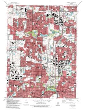
Lombard Topo Map Illinois
To zoom in, hover over the map of Lombard
USGS Topo Quad 41088h1 - 1:24,000 scale
| Topo Map Name: | Lombard |
| USGS Topo Quad ID: | 41088h1 |
| Print Size: | ca. 21 1/4" wide x 27" high |
| Southeast Coordinates: | 41.875° N latitude / 88° W longitude |
| Map Center Coordinates: | 41.9375° N latitude / 88.0625° W longitude |
| U.S. State: | IL |
| Filename: | o41088h1.jpg |
| Download Map JPG Image: | Lombard topo map 1:24,000 scale |
| Map Type: | Topographic |
| Topo Series: | 7.5´ |
| Map Scale: | 1:24,000 |
| Source of Map Images: | United States Geological Survey (USGS) |
| Alternate Map Versions: |
Lombard IL 1953, updated 1955 Download PDF Buy paper map Lombard IL 1962, updated 1964 Download PDF Buy paper map Lombard IL 1962, updated 1973 Download PDF Buy paper map Lombard IL 1962, updated 1981 Download PDF Buy paper map Lombard IL 1993, updated 1993 Download PDF Buy paper map Lombard IL 1998, updated 2002 Download PDF Buy paper map Lombard IL 2012 Download PDF Buy paper map Lombard IL 2015 Download PDF Buy paper map |
1:24,000 Topo Quads surrounding Lombard
> Back to 41088e1 at 1:100,000 scale
> Back to 41088a1 at 1:250,000 scale
> Back to U.S. Topo Maps home
Lombard topo map: Gazetteer
Lombard: Airports
Addison Fire Department Station 3 Heliport elevation 221m 725′Clarke Heliport elevation 244m 800′
Mitchell Field (historical) elevation 225m 738′
Schaumburg Air Park elevation 242m 793′
Lombard: Crossings
Interchange 5 elevation 217m 711′Interchange 7 elevation 213m 698′
Lombard: Dams
Lake Kadijah Dam elevation 212m 695′Lombard: Lakes
Lake Ellyn elevation 214m 702′Lake Kadijah elevation 212m 695′
Lombard: Parks
Academy Park elevation 235m 770′Ackerman Park elevation 215m 705′
Army Trail Nature Center elevation 217m 711′
Asa Douglas Harmon Wild Flower Preserve elevation 223m 731′
Black Willow Marsh County Forest Preserve elevation 240m 787′
Bloomingdale Grove elevation 235m 770′
Brookrose Park elevation 239m 784′
Campbell Slough County Forest Preserve elevation 213m 698′
Carson Park elevation 222m 728′
Centennial Park elevation 222m 728′
Chatburg Park elevation 233m 764′
Churchill Prairie Nature Preserve elevation 210m 688′
Churchill Woods County Forest Preserve elevation 211m 692′
Circle Park elevation 218m 715′
Claus Farm Recreation Area elevation 246m 807′
Community Park elevation 229m 751′
Cosley Park elevation 226m 741′
Depot Park elevation 234m 767′
East Branch Reserve County Forest Preserve elevation 217m 711′
Eastview Terrace Park elevation 223m 731′
Farmwood Park elevation 213m 698′
Four Seasons Park elevation 239m 784′
Foxdale Park elevation 216m 708′
Frazen Park elevation 216m 708′
Fullerton County Forest Preserve elevation 211m 692′
Gerald R Weeks Memorial Park elevation 235m 770′
Gilberto Park elevation 246m 807′
Gladstone Park elevation 236m 774′
Goose Lake Park elevation 235m 770′
Greenway Park elevation 221m 725′
Happy Acres Park elevation 210m 688′
Harold Reskin Park elevation 223m 731′
Indian Lakes Park elevation 238m 780′
James Clayson Park elevation 214m 702′
Jenson Park elevation 219m 718′
Jenson Park South elevation 217m 711′
Johnson Park elevation 218m 715′
Kemmering Park elevation 232m 761′
Kennedy Park elevation 244m 800′
Kenroy Park elevation 221m 725′
Lagoon Park elevation 219m 718′
Lake Ellyn Park elevation 219m 718′
Lake Manor Park elevation 209m 685′
Lake Street Reserve County Forest Preserve elevation 219m 718′
Lakeview Park elevation 212m 695′
Lilacia Park elevation 215m 705′
Lion Park elevation 226m 741′
Mallard Lake County Forest Preserve elevation 241m 790′
Manary Park elevation 227m 744′
Marion Park elevation 241m 790′
Mather Park elevation 220m 721′
Meacham Grove County Forest Preserve elevation 218m 715′
Medinah Park elevation 226m 741′
Memorial Park elevation 222m 728′
Mill Meadows Park elevation 209m 685′
Nerge Park elevation 232m 761′
New Castle Green Park elevation 238m 780′
Nike Park elevation 230m 754′
Nordic Park elevation 225m 738′
North Side Park elevation 222m 728′
Peacock Park elevation 213m 698′
Pine Park elevation 228m 748′
Post Office Park elevation 235m 770′
Rock Run Park elevation 241m 790′
Roosevelt Park elevation 214m 702′
Schillar Park elevation 206m 675′
Shenandaha Park elevation 220m 721′
Songbird Slough County Forest Preserve elevation 214m 702′
Spring Brook Park elevation 209m 685′
Springfield Park elevation 234m 767′
Springhill Park elevation 231m 757′
Stacy Park elevation 236m 774′
Sunnyside Park elevation 215m 705′
Sunset Park elevation 228m 748′
Swift Meadows County Forest Preserve elevation 221m 725′
Terrace View Park elevation 213m 698′
The Commons elevation 217m 711′
Tompkins Park elevation 232m 761′
Turner Park elevation 235m 770′
Usher Park elevation 213m 698′
Valley Park elevation 238m 780′
Vista Pond Park elevation 216m 708′
Washington Park elevation 213m 698′
Westlake Park elevation 218m 715′
Westwood Park elevation 213m 698′
Wheaton Driving Park (historical) elevation 229m 751′
White Hall Terrace Park elevation 239m 784′
Wilderness Park elevation 223m 731′
Lombard: Populated Places
Bloomingdale elevation 233m 764′Cloverdale elevation 234m 767′
Glen Ellyn elevation 226m 741′
Glen Oak elevation 216m 708′
Glendale Heights elevation 232m 761′
Gretna elevation 241m 790′
Itasca elevation 214m 702′
Keeneyville elevation 235m 770′
Lombard elevation 219m 718′
Medinah elevation 223m 731′
North Glen Ellyn elevation 225m 738′
Roselle elevation 235m 770′
Saddlewood elevation 232m 761′
Shorewood elevation 237m 777′
Swift elevation 223m 731′
Lombard: Post Offices
Bloomingdale Post Office elevation 236m 774′Cloverdale Post Office (historical) elevation 234m 767′
Glen Ellyn Post Office elevation 226m 741′
Lombard Post Office elevation 221m 725′
Roselle Post Office elevation 235m 770′
Lombard: Reservoirs
Turner Pond elevation 234m 767′Lombard: Streams
Meacham Creek elevation 215m 705′Lombard: Woods
Churchill Woods elevation 209m 685′Stacy Woods elevation 235m 770′
Lombard digital topo map on disk
Buy this Lombard topo map showing relief, roads, GPS coordinates and other geographical features, as a high-resolution digital map file on DVD:
Northern Illinois, Northern Indiana & Southwestern Michigan
Buy digital topo maps: Northern Illinois, Northern Indiana & Southwestern Michigan


