Coal Valley Topo Map Illinois
To zoom in, hover over the map of Coal Valley
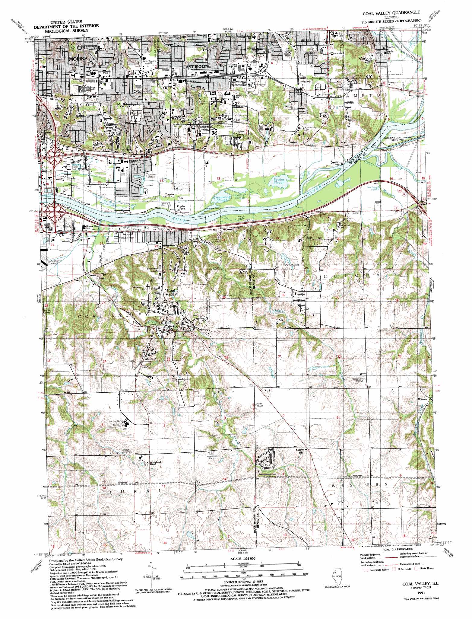
USGS Topo Quad 41090d4 - 1:24,000 scale
| Topo Map Name: | Coal Valley |
| USGS Topo Quad ID: | 41090d4 |
| Print Size: | ca. 21 1/4" wide x 27" high |
| Southeast Coordinates: | 41.375° N latitude / 90.375° W longitude |
| Map Center Coordinates: | 41.4375° N latitude / 90.4375° W longitude |
| U.S. State: | IL |
| Filename: | o41090d4.jpg |
| Download Map JPG Image: | Coal Valley topo map 1:24,000 scale |
| Map Type: | Topographic |
| Topo Series: | 7.5´ |
| Map Scale: | 1:24,000 |
| Source of Map Images: | United States Geological Survey (USGS) |
| Alternate Map Versions: |
Coal Valley IL 1949, updated 1949 Download PDF Buy paper map Coal Valley IL 1953, updated 1956 Download PDF Buy paper map Coal Valley IL 1953, updated 1971 Download PDF Buy paper map Coal Valley IL 1953, updated 1976 Download PDF Buy paper map Coal Valley IL 1991, updated 1992 Download PDF Buy paper map Coal Valley IL 2012 Download PDF Buy paper map Coal Valley IL 2015 Download PDF Buy paper map |
1:24,000 Topo Quads surrounding Coal Valley
Donahue |
Eldridge |
Mccausland |
Cordova |
Erie Nw |
Davenport West |
Davenport East |
Silvis |
Port Byron |
Hillsdale |
Andalusia |
Milan |
Coal Valley |
Green Rock |
Geneseo |
Reynolds |
Matherville |
Orion |
Andover |
Cambridge |
Aledo East |
Viola |
New Windsor |
Woodhull |
Nekoma |
> Back to 41090a1 at 1:100,000 scale
> Back to 41090a1 at 1:250,000 scale
> Back to U.S. Topo Maps home
Coal Valley topo map: Gazetteer
Coal Valley: Airports
Illini Hospital Heliport elevation 211m 692′Quad-City Seaplane Base elevation 168m 551′
Coal Valley: Crossings
Interchange 18 elevation 176m 577′Interchange 4 elevation 176m 577′
Interchange 5 elevation 176m 577′
Coal Valley: Dams
Lock Number 29 elevation 171m 561′Coal Valley: Guts
Bowles Slough elevation 172m 564′Coaltown Slough elevation 168m 551′
Greenwood Slough elevation 168m 551′
Coal Valley: Mines
Black Hawk Mine (historical) elevation 184m 603′Coal Valley: Parks
Coal Valley City Park elevation 211m 692′Friendship Park elevation 208m 682′
Green Valley Park elevation 174m 570′
J B Oakleaf Memorial Park elevation 214m 702′
L R Christian Memorial Field elevation 223m 731′
Niabi Zoo elevation 216m 708′
Timbrook Field elevation 174m 570′
Veterans Memorial Park elevation 176m 577′
Wiman Park elevation 207m 679′
Coal Valley: Populated Places
Brook Lawn elevation 222m 728′Carbon Cliff elevation 184m 603′
Coal Valley elevation 190m 623′
Glendale (historical) elevation 215m 705′
Poplar Grove elevation 171m 561′
Sunny Hill elevation 223m 731′
Sunny Hill Estates elevation 218m 715′
Timber Ridge elevation 209m 685′
Warner elevation 198m 649′
Coal Valley: Streams
Coal Creek elevation 168m 551′Green River elevation 168m 551′
Mosquito Creek elevation 170m 557′
Shaffer Creek elevation 168m 551′
Coal Valley digital topo map on disk
Buy this Coal Valley topo map showing relief, roads, GPS coordinates and other geographical features, as a high-resolution digital map file on DVD: