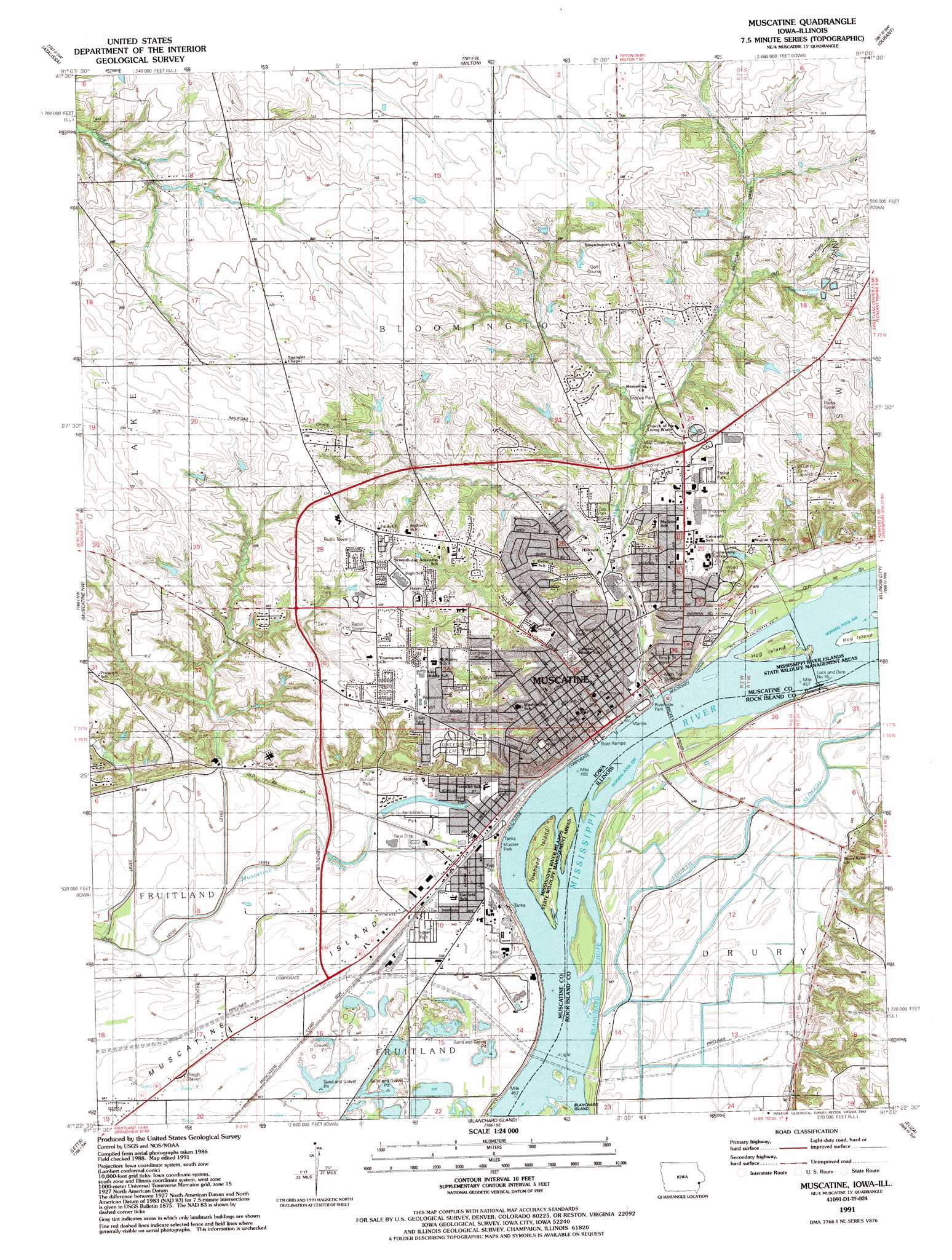
Muscatine Topo Map Iowa
To zoom in, hover over the map of Muscatine
USGS Topo Quad 41091d1 - 1:24,000 scale
| Topo Map Name: | Muscatine |
| USGS Topo Quad ID: | 41091d1 |
| Print Size: | ca. 21 1/4" wide x 27" high |
| Southeast Coordinates: | 41.375° N latitude / 91° W longitude |
| Map Center Coordinates: | 41.4375° N latitude / 91.0625° W longitude |
| U.S. States: | IA, IL |
| Filename: | o41091d1.jpg |
| Download Map JPG Image: | Muscatine topo map 1:24,000 scale |
| Map Type: | Topographic |
| Topo Series: | 7.5´ |
| Map Scale: | 1:24,000 |
| Source of Map Images: | United States Geological Survey (USGS) |
| Alternate Map Versions: |
Muscatine IA 1953, updated 1958 Download PDF Buy paper map Muscatine IA 1953, updated 1971 Download PDF Buy paper map Muscatine IA 1953, updated 1981 Download PDF Buy paper map Muscatine IA 1991, updated 1992 Download PDF Buy paper map Muscatine IA 2010 Download PDF Buy paper map Muscatine IA 2013 Download PDF Buy paper map Muscatine IA 2015 Download PDF Buy paper map |
1:24,000 Topo Quads surrounding Muscatine
West Branch |
Rochester |
Lime City |
Bennett |
Dixon |
West Liberty |
Atalissa |
Wilton Junction |
Durant |
Walcott |
Nichols |
Muscatine Nw |
Muscatine |
Illinois City |
Montpelier |
Columbus Junction |
Letts |
Blanchard Island |
Eliza |
Buffalo Prairie |
Cairo |
Wapello |
Toolesboro |
Joy |
Aledo West |
> Back to 41091a1 at 1:100,000 scale
> Back to 41090a1 at 1:250,000 scale
> Back to U.S. Topo Maps home
Muscatine topo map: Gazetteer
Muscatine: Bridges
Muscatine Highway Bridge (historical) elevation 165m 541′Norman F Beckey Bridge elevation 166m 544′
Muscatine: Dams
Lock and Dam Number 16 elevation 168m 551′Mississippi River Lock Dam Number Sixteen elevation 167m 547′
Muscatine: Islands
Hog Island elevation 167m 547′Hog Island elevation 166m 544′
Island Number 336 (historical) elevation 166m 544′
Muscatine Island elevation 165m 541′
Towhead Island elevation 167m 547′
Muscatine: Parks
Brook Street Park elevation 182m 597′Evermeyer Park elevation 194m 636′
Fourth Street Park elevation 215m 705′
Franklin Park elevation 166m 544′
Fuller Park elevation 214m 702′
John Duncan Park elevation 175m 574′
Kent-Stein Park elevation 191m 626′
Lincolnshire Park elevation 206m 675′
Longview Park elevation 201m 659′
Lucas Park elevation 217m 711′
Mad Creek Greenbelt Park elevation 185m 606′
Mc Kee Park elevation 181m 593′
Musser Park elevation 166m 544′
Oak Park elevation 185m 606′
Oregon Field elevation 166m 544′
Pecan Grove Reserve elevation 166m 544′
Riverside Park elevation 169m 554′
Taylor Park elevation 167m 547′
Weed Park elevation 199m 652′
Muscatine: Populated Places
Gaslight Square Trailer Park elevation 167m 547′Muscatine elevation 177m 580′
Van Ackers Mobile Home Park elevation 167m 547′
Muscatine: Post Offices
Muscatine Post Office elevation 214m 702′Muscatine: Streams
Fourth Slough elevation 166m 544′Mad Creek elevation 165m 541′
Muscatine digital topo map on disk
Buy this Muscatine topo map showing relief, roads, GPS coordinates and other geographical features, as a high-resolution digital map file on DVD: