Williamsburg Nw Topo Map Iowa
To zoom in, hover over the map of Williamsburg Nw
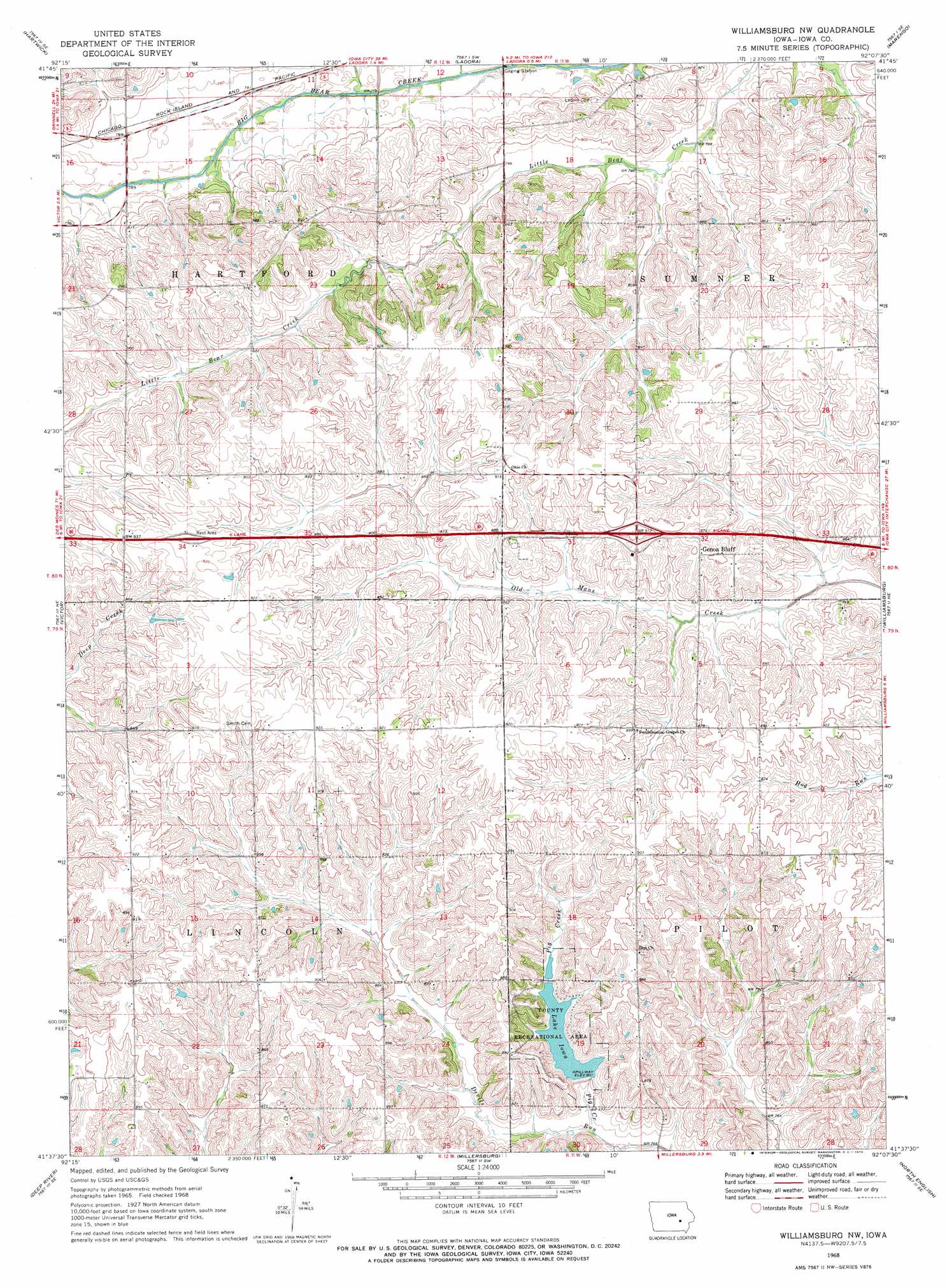
USGS Topo Quad 41092f2 - 1:24,000 scale
| Topo Map Name: | Williamsburg Nw |
| USGS Topo Quad ID: | 41092f2 |
| Print Size: | ca. 21 1/4" wide x 27" high |
| Southeast Coordinates: | 41.625° N latitude / 92.125° W longitude |
| Map Center Coordinates: | 41.6875° N latitude / 92.1875° W longitude |
| U.S. State: | IA |
| Filename: | o41092f2.jpg |
| Download Map JPG Image: | Williamsburg Nw topo map 1:24,000 scale |
| Map Type: | Topographic |
| Topo Series: | 7.5´ |
| Map Scale: | 1:24,000 |
| Source of Map Images: | United States Geological Survey (USGS) |
| Alternate Map Versions: |
Williamsburg NW IA 1968, updated 1970 Download PDF Buy paper map Williamsburg NW IA 2010 Download PDF Buy paper map Williamsburg NW IA 2013 Download PDF Buy paper map Williamsburg NW IA 2015 Download PDF Buy paper map |
1:24,000 Topo Quads surrounding Williamsburg Nw
Chelsea |
Belle Plaine |
Keystone South |
Blairstown |
Newhall |
Belle Plaine Sw |
Hartwick |
Ladora |
Marengo |
Middle Amana |
Brooklyn |
Victor |
Williamsburg Nw |
Williamsburg |
Conroy |
Barnes City |
Deep River |
Millersburg |
North English |
Holbrook |
Gibson |
What Cheer |
Keswick |
South English |
Kinross |
> Back to 41092e1 at 1:100,000 scale
> Back to 41092a1 at 1:250,000 scale
> Back to U.S. Topo Maps home
Williamsburg Nw topo map: Gazetteer
Williamsburg Nw: Crossings
Interchange 211 elevation 274m 898′Williamsburg Nw: Dams
Iowa Lake Dam elevation 247m 810′Williamsburg Nw: Parks
Historic Amana Colonies State Historical Marker elevation 281m 921′Lake Iowa County Recreation Area elevation 244m 800′
Williamsburg Nw: Populated Places
Gonoa Bluff elevation 272m 892′Williamsburg Nw: Post Offices
Genoa Bluff Post Office (historical) elevation 272m 892′Williamsburg Nw: Reservoirs
Lake Iowa elevation 244m 800′Williamsburg Nw: Streams
Pig Creek elevation 234m 767′Williamsburg Nw digital topo map on disk
Buy this Williamsburg Nw topo map showing relief, roads, GPS coordinates and other geographical features, as a high-resolution digital map file on DVD: