Chelsea Topo Map Iowa
To zoom in, hover over the map of Chelsea
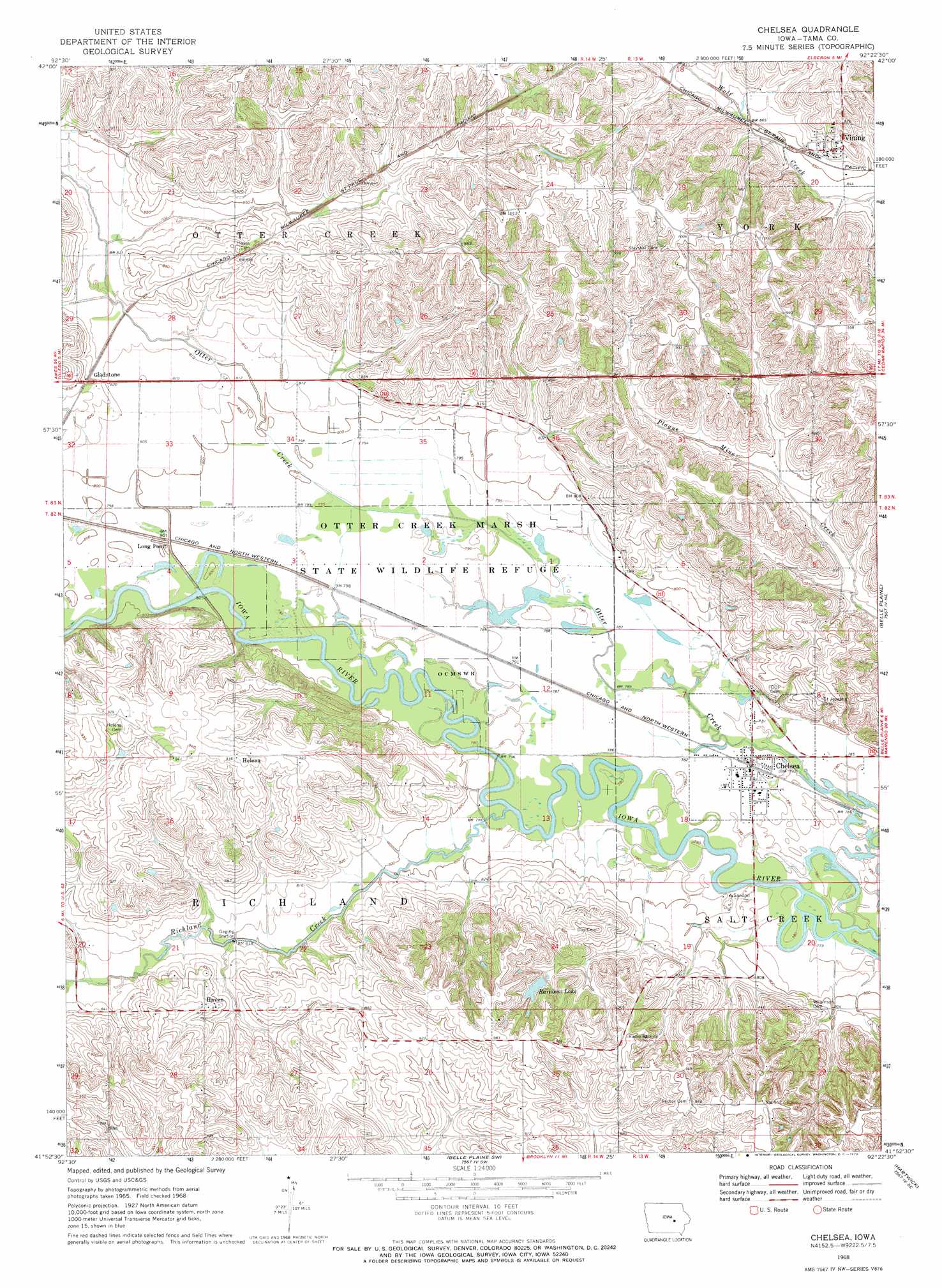
USGS Topo Quad 41092h4 - 1:24,000 scale
| Topo Map Name: | Chelsea |
| USGS Topo Quad ID: | 41092h4 |
| Print Size: | ca. 21 1/4" wide x 27" high |
| Southeast Coordinates: | 41.875° N latitude / 92.375° W longitude |
| Map Center Coordinates: | 41.9375° N latitude / 92.4375° W longitude |
| U.S. State: | IA |
| Filename: | o41092h4.jpg |
| Download Map JPG Image: | Chelsea topo map 1:24,000 scale |
| Map Type: | Topographic |
| Topo Series: | 7.5´ |
| Map Scale: | 1:24,000 |
| Source of Map Images: | United States Geological Survey (USGS) |
| Alternate Map Versions: |
Chelsea IA 1968, updated 1970 Download PDF Buy paper map Chelsea IA 2010 Download PDF Buy paper map Chelsea IA 2013 Download PDF Buy paper map Chelsea IA 2015 Download PDF Buy paper map |
1:24,000 Topo Quads surrounding Chelsea
Gladbrook |
Gladbrook Ne |
Traer |
Dysart |
Garrison |
Garwin |
Gladbrook Se |
Clutier |
Elberon |
Keystone North |
Montour |
Tama |
Chelsea |
Belle Plaine |
Keystone South |
Grinnell North |
Sheridan |
Belle Plaine Sw |
Hartwick |
Ladora |
Grinnell South |
Malcom |
Brooklyn |
Victor |
Williamsburg Nw |
> Back to 41092e1 at 1:100,000 scale
> Back to 41092a1 at 1:250,000 scale
> Back to U.S. Topo Maps home
Chelsea topo map: Gazetteer
Chelsea: Lakes
Rainbow Lake elevation 270m 885′Chelsea: Parks
Otter Creek Marsh State Wildlife Refuge elevation 241m 790′Site of Former Gladstone Historical Marker elevation 261m 856′
Site of Former Haven Historical Marker elevation 266m 872′
Site of Former Helena Historical Marker elevation 284m 931′
West Salt Creek Wildlife Area elevation 302m 990′
Chelsea: Populated Places
Chelsea elevation 238m 780′Gladstone elevation 260m 853′
Haven elevation 266m 872′
Helena elevation 285m 935′
Long Point elevation 244m 800′
Vining elevation 273m 895′
Chelsea: Post Offices
Chelsea Post Office elevation 238m 780′Eureka Post Office (historical) elevation 266m 872′
Gladstone Post Office (historical) elevation 260m 853′
Haven Post Office (historical) elevation 266m 872′
Helena Post Office (historical) elevation 242m 793′
Kinisaw Post Office (historical) elevation 238m 780′
Long Point Post Office (historical) elevation 244m 800′
Tamaville Post Office (historical) elevation 270m 885′
Vining Post Office elevation 273m 895′
Chelsea: Streams
Richland Creek elevation 238m 780′Chelsea digital topo map on disk
Buy this Chelsea topo map showing relief, roads, GPS coordinates and other geographical features, as a high-resolution digital map file on DVD: