Gilman Topo Map Iowa
To zoom in, hover over the map of Gilman
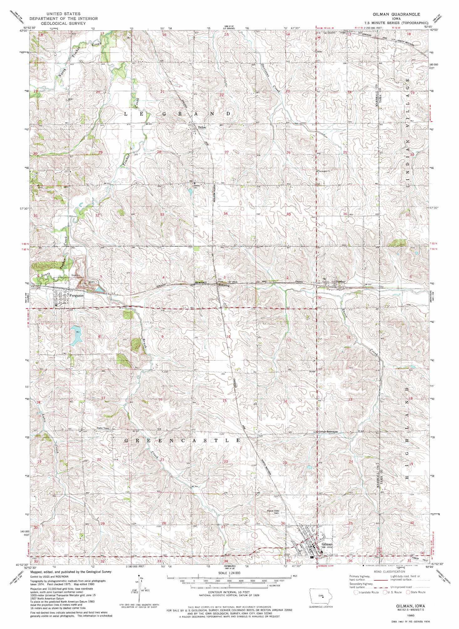
USGS Topo Quad 41092h7 - 1:24,000 scale
| Topo Map Name: | Gilman |
| USGS Topo Quad ID: | 41092h7 |
| Print Size: | ca. 21 1/4" wide x 27" high |
| Southeast Coordinates: | 41.875° N latitude / 92.75° W longitude |
| Map Center Coordinates: | 41.9375° N latitude / 92.8125° W longitude |
| U.S. State: | IA |
| Filename: | o41092h7.jpg |
| Download Map JPG Image: | Gilman topo map 1:24,000 scale |
| Map Type: | Topographic |
| Topo Series: | 7.5´ |
| Map Scale: | 1:24,000 |
| Source of Map Images: | United States Geological Survey (USGS) |
| Alternate Map Versions: |
Gilman IA 1980, updated 1980 Download PDF Buy paper map Gilman IA 2010 Download PDF Buy paper map Gilman IA 2013 Download PDF Buy paper map Gilman IA 2015 Download PDF Buy paper map |
1:24,000 Topo Quads surrounding Gilman
Union |
Conrad West |
Conrad East |
Gladbrook |
Gladbrook Ne |
La Moille |
Marshalltown |
Le Grand |
Garwin |
Gladbrook Se |
Melbourne |
Laurel |
Gilman |
Montour |
Tama |
Baxter Se |
Alloway Creek |
Newburg |
Grinnell North |
Sheridan |
Newton |
Kellogg |
Oakland Acres |
Grinnell South |
Malcom |
> Back to 41092e1 at 1:100,000 scale
> Back to 41092a1 at 1:250,000 scale
> Back to U.S. Topo Maps home
Gilman topo map: Gazetteer
Gilman: Airports
Esbeck Field elevation 312m 1023′Gilman: Mines
Ferguson Quarry elevation 277m 908′Gilman: Parks
Dillon Park elevation 299m 980′Green Castle Recreation Area elevation 296m 971′
Gilman: Populated Places
Dillon elevation 299m 980′Dunbar elevation 284m 931′
Ferguson elevation 284m 931′
Gilman elevation 313m 1026′
Pickering elevation 304m 997′
Gilman: Post Offices
Dillon Post Office (historical) elevation 299m 980′Dunbar Post Office (historical) elevation 284m 931′
Ferguson Post Office elevation 280m 918′
Gilman Post Office elevation 314m 1030′
Pickering Post Office (historical) elevation 304m 997′
Gilman: Streams
Brush Creek elevation 269m 882′North Timber Creek elevation 262m 859′
South Timber Creek elevation 283m 928′
Gilman digital topo map on disk
Buy this Gilman topo map showing relief, roads, GPS coordinates and other geographical features, as a high-resolution digital map file on DVD: