Des Moines Nw Topo Map Iowa
To zoom in, hover over the map of Des Moines Nw
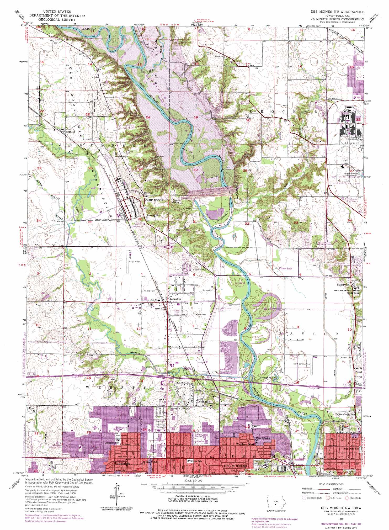
USGS Topo Quad 41093f6 - 1:24,000 scale
| Topo Map Name: | Des Moines Nw |
| USGS Topo Quad ID: | 41093f6 |
| Print Size: | ca. 21 1/4" wide x 27" high |
| Southeast Coordinates: | 41.625° N latitude / 93.625° W longitude |
| Map Center Coordinates: | 41.6875° N latitude / 93.6875° W longitude |
| U.S. State: | IA |
| Filename: | o41093f6.jpg |
| Download Map JPG Image: | Des Moines Nw topo map 1:24,000 scale |
| Map Type: | Topographic |
| Topo Series: | 7.5´ |
| Map Scale: | 1:24,000 |
| Source of Map Images: | United States Geological Survey (USGS) |
| Alternate Map Versions: |
Des Moines NW IA 1956, updated 1958 Download PDF Buy paper map Des Moines NW IA 1956, updated 1968 Download PDF Buy paper map Des Moines NW IA 1956, updated 1972 Download PDF Buy paper map Des Moines NW IA 1956, updated 1977 Download PDF Buy paper map Des Moines NW IA 1956, updated 1977 Download PDF Buy paper map Des Moines NW IA 2010 Download PDF Buy paper map Des Moines NW IA 2013 Download PDF Buy paper map Des Moines NW IA 2015 Download PDF Buy paper map |
1:24,000 Topo Quads surrounding Des Moines Nw
Madrid Nw |
Luther |
Slater |
Huxley |
Maxwell |
Woodward |
Granger |
Polk City |
Elkhart |
Loring |
Dallas Center |
Grimes |
Des Moines Nw |
Des Moines Ne |
Altoona |
Waukee |
Commerce |
Des Moines Sw |
Des Moines Se |
Rising Sun |
Saint Charles Nw |
Cumming |
Norwalk |
Scotch Ridge |
Hartford |
> Back to 41093e1 at 1:100,000 scale
> Back to 41092a1 at 1:250,000 scale
> Back to U.S. Topo Maps home
Des Moines Nw topo map: Gazetteer
Des Moines Nw: Airports
Dodge Airport elevation 254m 833′Kern Field elevation 267m 875′
Morningstar Field elevation 244m 800′
North Landing Field elevation 244m 800′
Des Moines Nw: Bridges
Corydon Bridge (historical) elevation 253m 830′Des Moines Nw: Crossings
Interchange 129 elevation 294m 964′Interchange 131 elevation 246m 807′
Des Moines Nw: Dams
Saylorville Dam elevation 276m 905′Des Moines Nw: Lakes
Horseshoe Lake elevation 244m 800′Des Moines Nw: Parks
Glenbrooke Park elevation 289m 948′Greentree Park elevation 293m 961′
Karen Acres elevation 273m 895′
Lions Park elevation 293m 961′
McHenry Park elevation 264m 866′
North Creek Park elevation 291m 954′
Northview Park elevation 280m 918′
Sycamore Park elevation 244m 800′
Urbandale City Park elevation 272m 892′
Walker-Johnson Park elevation 270m 885′
Westchester Park elevation 276m 905′
Woodlawn Park elevation 264m 866′
Des Moines Nw: Populated Places
Camp Dodge elevation 301m 987′Corydon (historical) elevation 286m 938′
Herrold elevation 259m 849′
Johnston elevation 253m 830′
Lovington elevation 270m 885′
Mel-Ray Mobile Home Park elevation 290m 951′
Saylorville elevation 271m 889′
Urbandale elevation 288m 944′
Des Moines Nw: Post Offices
Everton Post Office (historical) elevation 278m 912′Herrold Post Office (historical) elevation 259m 849′
Johnston Post Office elevation 253m 830′
Keen Post Office (historical) elevation 270m 885′
Kirkwood Post Office (historical) elevation 252m 826′
McDevitt Post Office (historical) elevation 290m 951′
Ridgedale Post Office (historical) elevation 304m 997′
Saylorville Post Office (historical) elevation 271m 889′
Urbandale Post Office elevation 273m 895′
Des Moines Nw: Reservoirs
Faith Pond elevation 293m 961′Saylorville Lake elevation 259m 849′
Des Moines Nw: Streams
Beaver Creek elevation 244m 800′Big Creek elevation 253m 830′
Little Beaver Creek elevation 247m 810′
Rock Creek elevation 244m 800′
Saylor Creek elevation 239m 784′
Des Moines Nw: Swamps
Fisher Lake elevation 242m 793′Des Moines Nw digital topo map on disk
Buy this Des Moines Nw topo map showing relief, roads, GPS coordinates and other geographical features, as a high-resolution digital map file on DVD: