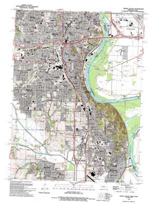
Omaha South Topo Map Nebraska
To zoom in, hover over the map of Omaha South
USGS Topo Quad 41095b8 - 1:24,000 scale
| Topo Map Name: | Omaha South |
| USGS Topo Quad ID: | 41095b8 |
| Print Size: | ca. 21 1/4" wide x 27" high |
| Southeast Coordinates: | 41.125° N latitude / 95.875° W longitude |
| Map Center Coordinates: | 41.1875° N latitude / 95.9375° W longitude |
| U.S. States: | NE, IA |
| Filename: | O41095B8.jpg |
| Download Map JPG Image: | Omaha South topo map 1:24,000 scale |
| Map Type: | Topographic |
| Topo Series: | 7.5´ |
| Map Scale: | 1:24,000 |
| Source of Map Images: | United States Geological Survey (USGS) |
| Alternate Map Versions: |
Omaha South NE 1956, updated 1958 Download PDF Buy paper map Omaha South NE 1956, updated 1967 Download PDF Buy paper map Omaha South NE 1956, updated 1970 Download PDF Buy paper map Omaha South NE 1956, updated 1977 Download PDF Buy paper map Omaha South NE 1956, updated 1984 Download PDF Buy paper map Omaha South NE 1956, updated 1989 Download PDF Buy paper map Omaha South NE 1994, updated 1995 Download PDF Buy paper map Omaha South NE 2010 Download PDF Buy paper map Omaha South NE 2011 Download PDF Buy paper map Omaha South NE 2014 Download PDF Buy paper map |
1:24,000 Topo Quads surrounding Omaha South
> Back to 41095a1 at 1:100,000 scale
> Back to 41094a1 at 1:250,000 scale
> Back to U.S. Topo Maps home
Omaha South topo map: Gazetteer
Omaha South: Airports
Ruckl Airport elevation 296m 971′Omaha South: Bends
Gibson Bend elevation 290m 951′Gibson Bend elevation 290m 951′
Omaha Bend elevation 293m 961′
Omaha Bend elevation 293m 961′
Omaha South: Crossings
Interchange 1A elevation 344m 1128′Interchange 1A elevation 303m 994′
Interchange 1B elevation 301m 987′
Interchange 451 elevation 367m 1204′
Interchange 452 elevation 373m 1223′
Interchange 453 elevation 367m 1204′
Interchange 454 elevation 335m 1099′
Interchange 51 elevation 303m 994′
Interchange 52 elevation 300m 984′
Omaha South: Parks
Albright Park elevation 326m 1069′Athletic Park elevation 339m 1112′
Athletic Park elevation 340m 1115′
Baldwin Field elevation 352m 1154′
Bellevue Depot Historical Marker elevation 295m 967′
Bellevue Log Cabin Historical Marker elevation 317m 1040′
Brown Park elevation 341m 1118′
Christie Heights Park elevation 374m 1227′
Churchich Park elevation 343m 1125′
Columbus Park elevation 339m 1112′
Dahlman Park elevation 351m 1151′
Deer Park elevation 345m 1131′
Don Roddy Field Sports Complex elevation 331m 1085′
Essex Park elevation 357m 1171′
Everett Park elevation 309m 1013′
Fifty-Fourth and Holmes Street Park elevation 343m 1125′
First Presbyterian Church Historical Marker elevation 317m 1040′
Fontenelle Bank - County Courthouse Historical Marker elevation 315m 1033′
Fontenelle Forest Nature Center elevation 354m 1161′
Freeman Park elevation 361m 1184′
Gemini Park elevation 326m 1069′
Gilder Park elevation 356m 1167′
Glenmorrie Park elevation 322m 1056′
Golden Hills Park elevation 319m 1046′
Goldenrod Park elevation 340m 1115′
Hanscom Park elevation 353m 1158′
Harper Park elevation 331m 1085′
Harrison Heights Park elevation 359m 1177′
Harveys Recreation Complex elevation 297m 974′
Haworth Park elevation 299m 980′
Heber Park elevation 339m 1112′
Henry Doorly Zoo elevation 319m 1046′
Highland Park elevation 375m 1230′
Hitchcock Park elevation 326m 1069′
James F Lynch Park elevation 338m 1108′
Jerry Gilbert Park elevation 305m 1000′
Jewell Park elevation 332m 1089′
Malmare Park elevation 296m 971′
Mandan park elevation 317m 1040′
Mason Park elevation 359m 1177′
McCann Park elevation 333m 1092′
McKinley Park elevation 362m 1187′
Morton Park elevation 358m 1174′
Mount Vernon Gardens elevation 339m 1112′
Municipal Stadium elevation 351m 1151′
Munnelly Park elevation 343m 1125′
North Field - College Heights elevation 320m 1049′
Omaha Botanical Gardens elevation 332m 1089′
President Gerald R Ford Birthsite elevation 376m 1233′
Pulaski Park elevation 376m 1233′
Reed Community Center elevation 325m 1066′
Riverside Park elevation 299m 980′
Riverview Park elevation 318m 1043′
Rosenblatt Stadium elevation 350m 1148′
Royals Court elevation 344m 1128′
Schroeder Park elevation 322m 1056′
Sorenson Park elevation 346m 1135′
Spring Lake Park elevation 327m 1072′
Sun Valley Park elevation 302m 990′
Swanson Park elevation 309m 1013′
Thompson Park elevation 312m 1023′
Twin City Park elevation 296m 971′
Twin Ridge Park elevation 309m 1013′
Unity Park elevation 343m 1125′
Upland Park elevation 337m 1105′
Vogel Park elevation 322m 1056′
Washington Park elevation 317m 1040′
Western Historic Trails Center elevation 300m 984′
Zorinsky Air Park elevation 303m 994′
Omaha South: Populated Places
Avery elevation 318m 1043′Bellevue elevation 315m 1033′
Capehart elevation 320m 1049′
Fort Crook elevation 298m 977′
Gilmore elevation 302m 990′
Gilmore Junction elevation 305m 1000′
Green Acres Mobile Home Park elevation 298m 977′
Martinview Mobile Home Park elevation 307m 1007′
Rumsey elevation 320m 1049′
South Omaha elevation 360m 1181′
Washington Mobile Home Terrace elevation 314m 1030′
Omaha South: Post Offices
Avery Post Office (historical) elevation 318m 1043′Bellevue Post Office elevation 334m 1095′
C Station elevation 366m 1200′
Elmwood Park Post Office Station elevation 322m 1056′
Elmwood Post Office Station elevation 330m 1082′
Fort Crook Post Office (historical) elevation 298m 977′
Gilmore Post Office (historical) elevation 302m 990′
Omaha Post Office elevation 328m 1076′
Pierce Street Station elevation 340m 1115′
South Omaha Post Office Station elevation 356m 1167′
Omaha South: Streams
Behm Creek elevation 297m 974′Betz Road Ditch elevation 290m 951′
Big Elk Creek elevation 293m 961′
Big Papillion Creek elevation 290m 951′
Copper Creek elevation 293m 961′
Fort Crook Creek elevation 290m 951′
Fricke Creek elevation 296m 971′
Mud Creek elevation 290m 951′
Old Home Creek elevation 318m 1043′
Quail Creek elevation 294m 964′
West Quail Creek elevation 290m 951′
Wolf Creek elevation 302m 990′
Omaha South: Trails
Copper Creek Connector Trail elevation 297m 974′Field Club Trail elevation 366m 1200′
Fontenelle Forest National Recreation Trail elevation 353m 1158′
Omaha South digital topo map on disk
Buy this Omaha South topo map showing relief, roads, GPS coordinates and other geographical features, as a high-resolution digital map file on DVD:


