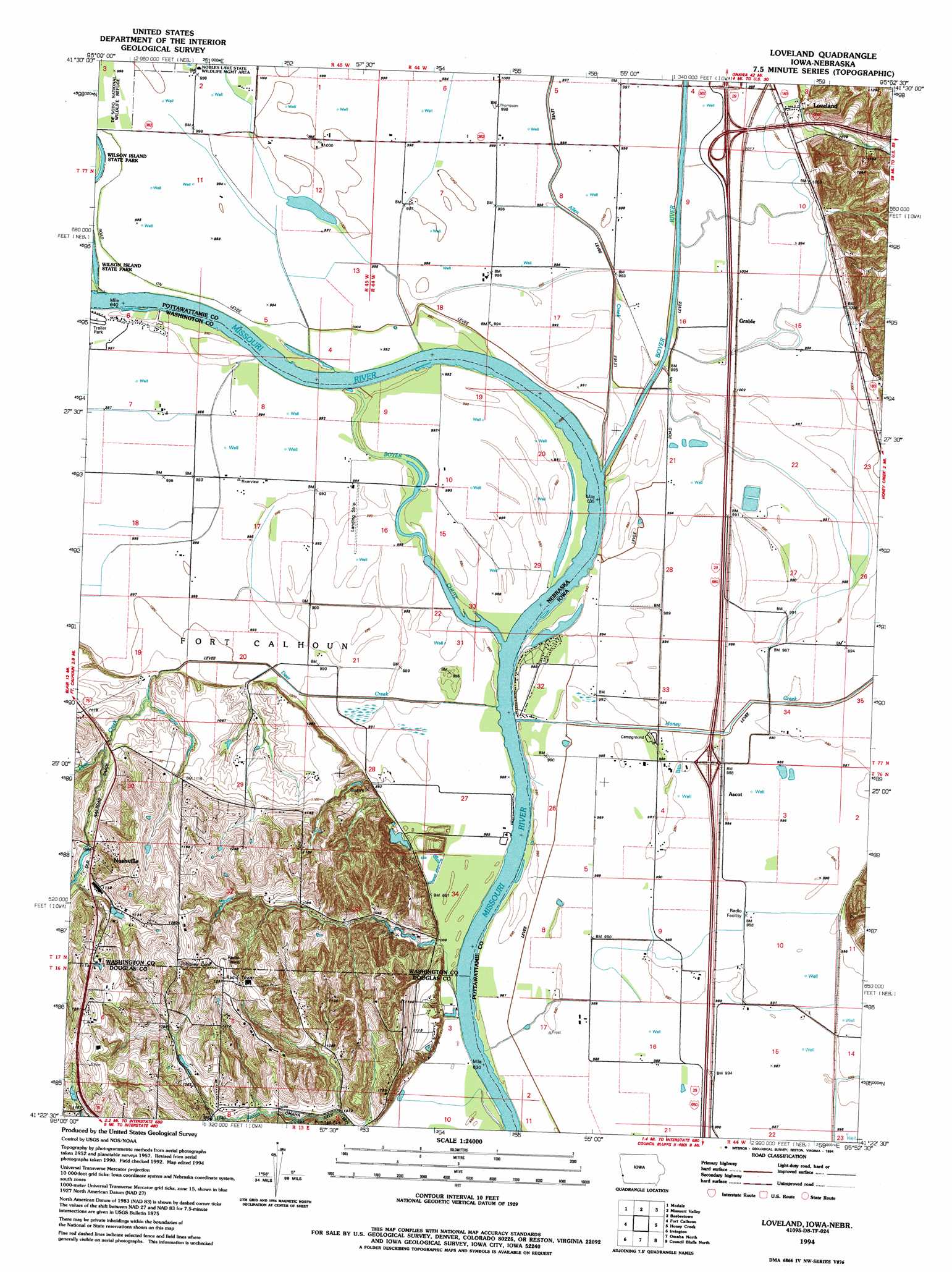
Loveland Topo Map Iowa
To zoom in, hover over the map of Loveland
USGS Topo Quad 41095d8 - 1:24,000 scale
| Topo Map Name: | Loveland |
| USGS Topo Quad ID: | 41095d8 |
| Print Size: | ca. 21 1/4" wide x 27" high |
| Southeast Coordinates: | 41.375° N latitude / 95.875° W longitude |
| Map Center Coordinates: | 41.4375° N latitude / 95.9375° W longitude |
| U.S. States: | IA, NE |
| Filename: | o41095d8.jpg |
| Download Map JPG Image: | Loveland topo map 1:24,000 scale |
| Map Type: | Topographic |
| Topo Series: | 7.5´ |
| Map Scale: | 1:24,000 |
| Source of Map Images: | United States Geological Survey (USGS) |
| Alternate Map Versions: |
Loveland IA 1957, updated 1958 Download PDF Buy paper map Loveland IA 1957, updated 1970 Download PDF Buy paper map Loveland IA 1957, updated 1977 Download PDF Buy paper map Loveland IA 1994, updated 1994 Download PDF Buy paper map Loveland IA 2010 Download PDF Buy paper map Loveland IA 2013 Download PDF Buy paper map Loveland IA 2015 Download PDF Buy paper map |
1:24,000 Topo Quads surrounding Loveland
Herman |
Mondamin |
Missouri Valley Nw |
Logan |
Woodbine |
Blair |
Modale |
Missouri Valley |
Beebeetown |
Hard Scratch |
Kennard |
Fort Calhoun |
Loveland |
Honey Creek |
Underwood |
Elkhorn |
Irvington |
Omaha North |
Council Bluffs North |
Mcclelland |
Gretna |
Ralston |
Omaha South |
Council Bluffs South |
Mineola |
> Back to 41095a1 at 1:100,000 scale
> Back to 41094a1 at 1:250,000 scale
> Back to U.S. Topo Maps home
Loveland topo map: Gazetteer
Loveland: Airports
Heaton Airport elevation 302m 990′Loveland: Bends
Boyer Bend elevation 296m 971′Boyer Bend elevation 296m 971′
Lower Calhoun Bend elevation 299m 980′
Lower Calhoun Bend elevation 299m 980′
Loveland: Crossings
Interchange 66 elevation 306m 1003′Interchange 71 elevation 304m 997′
Interchange 72 elevation 305m 1000′
Loveland: Dams
Exley Dam elevation 331m 1085′Jungbluth Dam elevation 339m 1112′
McCarthy Dam elevation 346m 1135′
Loveland: Lakes
Honey Lake (historical) elevation 302m 990′Loveland: Parks
Boyer Chute National Wildlife Refuge elevation 302m 990′Hummel Park elevation 328m 1076′
Neale Woods Nature Center elevation 360m 1181′
Shipley Cemetery Historical Marker elevation 318m 1043′
Loveland: Populated Places
Ascot elevation 302m 990′Grable elevation 304m 997′
Loveland elevation 310m 1017′
Nashville elevation 335m 1099′
Loveland: Post Offices
Ascot Post Office (historical) elevation 302m 990′Grable Post Office (historical) elevation 304m 997′
Loveland Post Office (historical) elevation 310m 1017′
Nashville Post Office (historical) elevation 335m 1099′
Willow Post Office (historical) elevation 318m 1043′
Loveland: Reservoirs
Exley Reservoir elevation 331m 1085′Jungbluth Reservoir elevation 339m 1112′
McCarthy Reservoir elevation 346m 1135′
Loveland: Streams
Allen Creek elevation 296m 971′Boyer Chute elevation 302m 990′
Boyer River elevation 296m 971′
Deer Creek elevation 299m 980′
Honey Creek elevation 299m 980′
Loveland: Trails
Boyer Chute Trails elevation 302m 990′Loveland digital topo map on disk
Buy this Loveland topo map showing relief, roads, GPS coordinates and other geographical features, as a high-resolution digital map file on DVD: