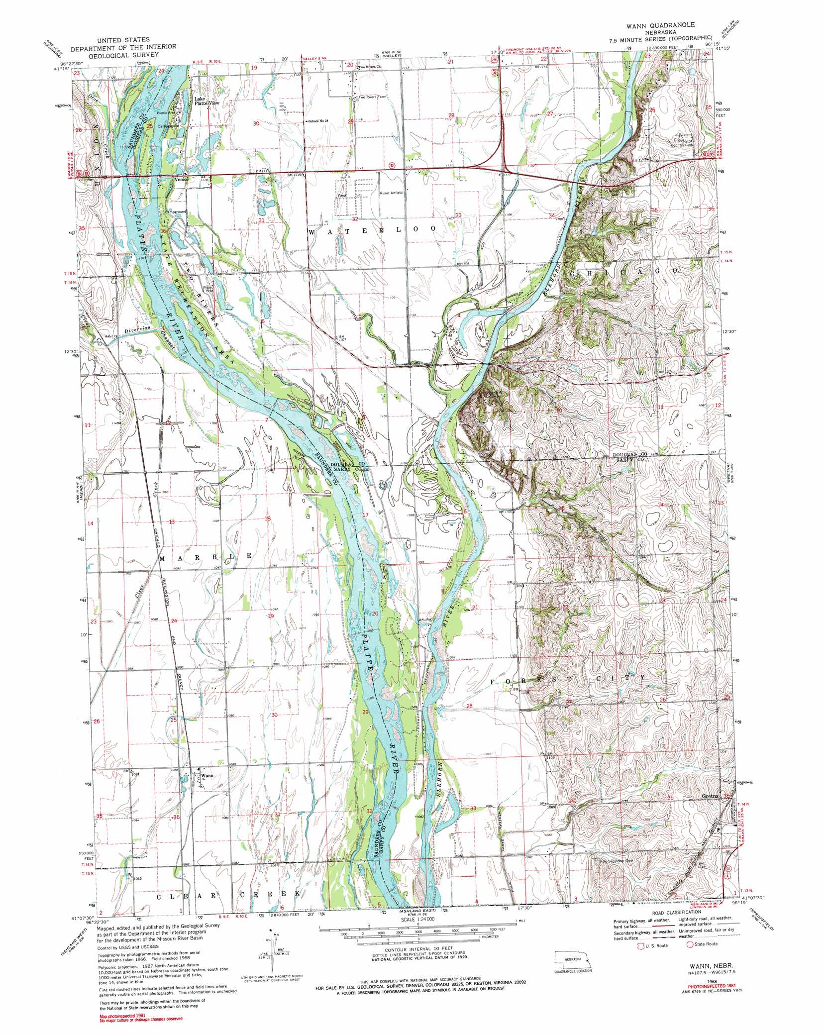
Wann Topo Map Nebraska
To zoom in, hover over the map of Wann
USGS Topo Quad 41096b3 - 1:24,000 scale
| Topo Map Name: | Wann |
| USGS Topo Quad ID: | 41096b3 |
| Print Size: | ca. 21 1/4" wide x 27" high |
| Southeast Coordinates: | 41.125° N latitude / 96.25° W longitude |
| Map Center Coordinates: | 41.1875° N latitude / 96.3125° W longitude |
| U.S. State: | NE |
| Filename: | O41096B3.jpg |
| Download Map JPG Image: | Wann topo map 1:24,000 scale |
| Map Type: | Topographic |
| Topo Series: | 7.5´ |
| Map Scale: | 1:24,000 |
| Source of Map Images: | United States Geological Survey (USGS) |
| Alternate Map Versions: |
Wann NE 1968, updated 1971 Download PDF Buy paper map Wann NE 1968, updated 1979 Download PDF Buy paper map Wann NE 2011 Download PDF Buy paper map Wann NE 2014 Download PDF Buy paper map |
1:24,000 Topo Quads surrounding Wann
Fremont West |
Fremont East |
Arlington |
Kennard |
Fort Calhoun |
Colon |
Leshara |
Valley |
Elkhorn |
Irvington |
Wahoo East |
Mead |
Wann |
Gretna |
Ralston |
Wahoo Se |
Ashland West |
Ashland East |
Springfield |
Cedar Creek |
Waverly |
Greenwood |
Murdock |
Manley |
Weeping Water Ne |
> Back to 41096a1 at 1:100,000 scale
> Back to 41096a1 at 1:250,000 scale
> Back to U.S. Topo Maps home
Wann topo map: Gazetteer
Wann: Canals
Diversion Channel elevation 338m 1108′Wann: Lakes
Trout Lake elevation 338m 1108′Wann: Parks
Caboose Park elevation 338m 1108′Oto Indians Historical Marker elevation 339m 1112′
Two Rivers State Recreation Area elevation 338m 1108′
Wann: Populated Places
Big Sandy Lake elevation 329m 1079′Lake Platte View elevation 341m 1118′
Venice elevation 341m 1118′
Wann elevation 332m 1089′
Wann: Post Offices
Wann Post Office (historical) elevation 332m 1089′Wann: Streams
Otoe Creek elevation 338m 1108′Wann digital topo map on disk
Buy this Wann topo map showing relief, roads, GPS coordinates and other geographical features, as a high-resolution digital map file on DVD: