Wahoo West Topo Map Nebraska
To zoom in, hover over the map of Wahoo West
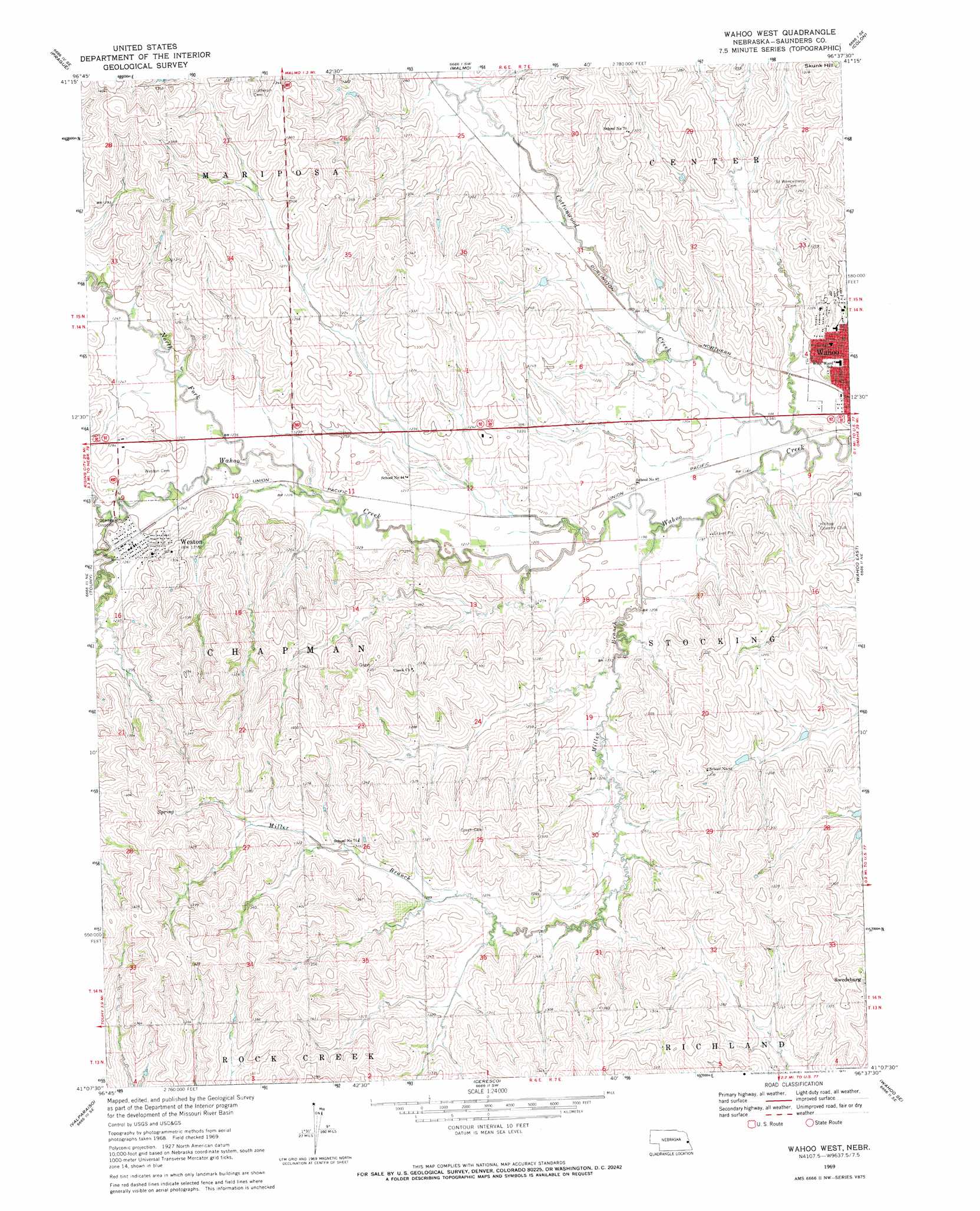
USGS Topo Quad 41096b6 - 1:24,000 scale
| Topo Map Name: | Wahoo West |
| USGS Topo Quad ID: | 41096b6 |
| Print Size: | ca. 21 1/4" wide x 27" high |
| Southeast Coordinates: | 41.125° N latitude / 96.625° W longitude |
| Map Center Coordinates: | 41.1875° N latitude / 96.6875° W longitude |
| U.S. State: | NE |
| Filename: | O41096B6.jpg |
| Download Map JPG Image: | Wahoo West topo map 1:24,000 scale |
| Map Type: | Topographic |
| Topo Series: | 7.5´ |
| Map Scale: | 1:24,000 |
| Source of Map Images: | United States Geological Survey (USGS) |
| Alternate Map Versions: |
Wahoo West NE 1969, updated 1971 Download PDF Buy paper map Wahoo West NE 2011 Download PDF Buy paper map Wahoo West NE 2014 Download PDF Buy paper map |
1:24,000 Topo Quads surrounding Wahoo West
Rogers |
North Bend |
Malmo Nw |
Fremont West |
Fremont East |
Bruno |
Prague |
Malmo |
Colon |
Leshara |
Loma |
Touhy |
Wahoo West |
Wahoo East |
Mead |
Valparaiso Sw |
Valparaiso |
Ceresco |
Wahoo Se |
Ashland West |
Garland |
Raymond |
Davey |
Waverly |
Greenwood |
> Back to 41096a1 at 1:100,000 scale
> Back to 41096a1 at 1:250,000 scale
> Back to U.S. Topo Maps home
Wahoo West topo map: Gazetteer
Wahoo West: Dams
Chapek Dam elevation 382m 1253′Cottonwood Creek Dam 23-A elevation 381m 1250′
Kavan Dam 1 elevation 371m 1217′
Kavan Dam 2 elevation 375m 1230′
Roberts Dam elevation 372m 1220′
Swedeburg Dam 2B-2F elevation 376m 1233′
Thorston Dam B-2 elevation 384m 1259′
Thorston Dam B-2A elevation 373m 1223′
Wahoo West: Parks
Hackberry Park elevation 365m 1197′Triangle Park elevation 375m 1230′
Wahoo West: Populated Places
Weston elevation 381m 1250′Wahoo West: Post Offices
Weston Post Office elevation 381m 1250′Wahoo West: Reservoirs
Chapek Reservoir elevation 382m 1253′Cottonwood Creek Reservoir 23-A elevation 381m 1250′
Kavan Reservoir 1 elevation 371m 1217′
Kavan Reservoir 2 elevation 375m 1230′
Roberts Reservoir elevation 372m 1220′
Swedeburg Reservoir 2B-2F elevation 376m 1233′
Thorston Reservoir B-2 elevation 384m 1259′
Thorston Reservoir B-2A elevation 373m 1223′
Wahoo West: Streams
Cottonwood Creek elevation 361m 1184′Dunlap Creek elevation 378m 1240′
Miller Branch elevation 363m 1190′
North Fork Wahoo Creek elevation 370m 1213′
Wahoo West digital topo map on disk
Buy this Wahoo West topo map showing relief, roads, GPS coordinates and other geographical features, as a high-resolution digital map file on DVD: