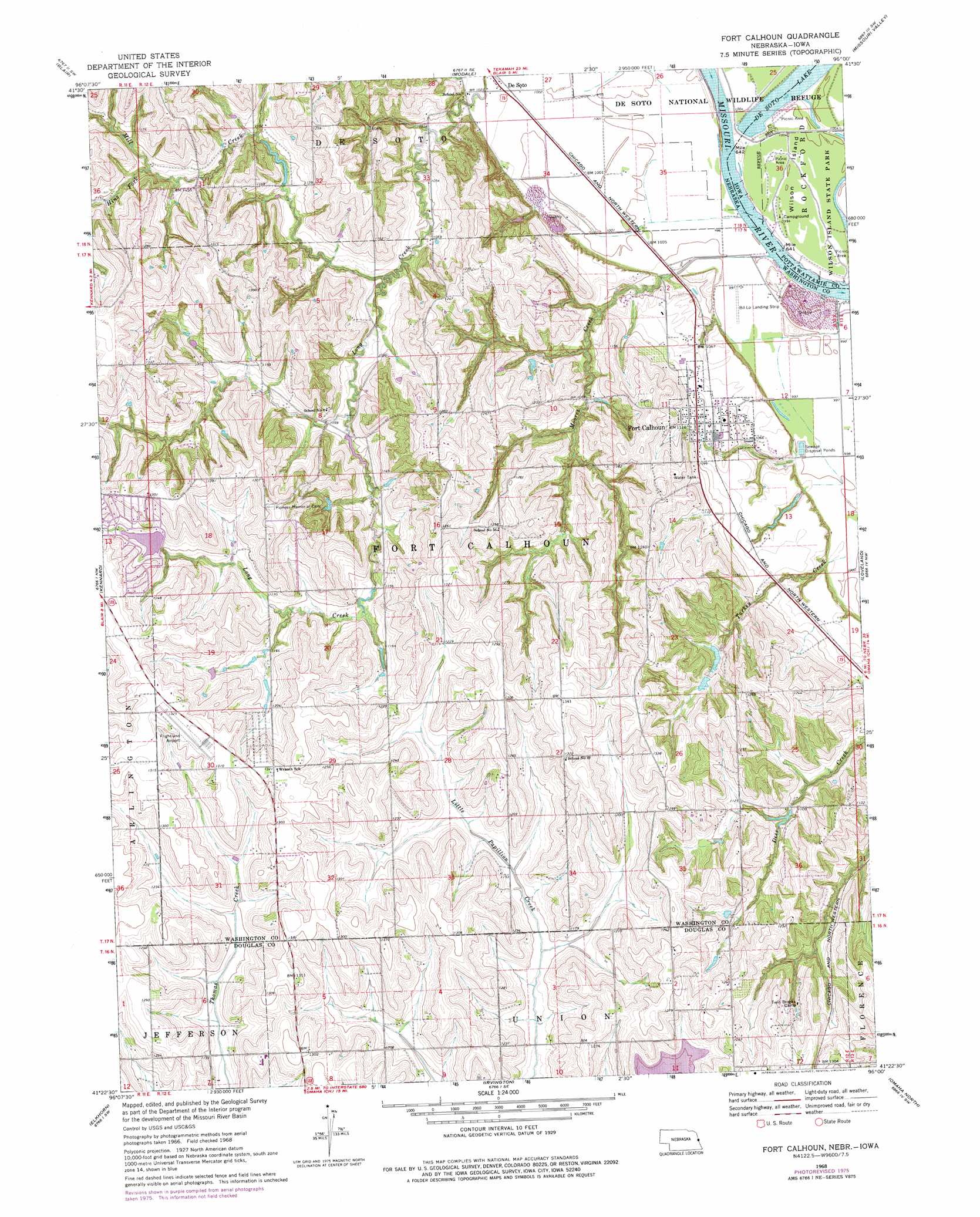
Fort Calhoun Topo Map Nebraska
To zoom in, hover over the map of Fort Calhoun
USGS Topo Quad 41096d1 - 1:24,000 scale
| Topo Map Name: | Fort Calhoun |
| USGS Topo Quad ID: | 41096d1 |
| Print Size: | ca. 21 1/4" wide x 27" high |
| Southeast Coordinates: | 41.375° N latitude / 96° W longitude |
| Map Center Coordinates: | 41.4375° N latitude / 96.0625° W longitude |
| U.S. States: | NE, IA |
| Filename: | O41096D1.jpg |
| Download Map JPG Image: | Fort Calhoun topo map 1:24,000 scale |
| Map Type: | Topographic |
| Topo Series: | 7.5´ |
| Map Scale: | 1:24,000 |
| Source of Map Images: | United States Geological Survey (USGS) |
| Alternate Map Versions: |
Fort Calhoun NE 1968, updated 1971 Download PDF Buy paper map Fort Calhoun NE 1968, updated 1977 Download PDF Buy paper map Fort Calhoun NE 2010 Download PDF Buy paper map Fort Calhoun NE 2011 Download PDF Buy paper map Fort Calhoun NE 2014 Download PDF Buy paper map |
1:24,000 Topo Quads surrounding Fort Calhoun
Nickerson Ne |
Herman |
Mondamin |
Missouri Valley Nw |
Logan |
Orum |
Blair |
Modale |
Missouri Valley |
Beebeetown |
Arlington |
Kennard |
Fort Calhoun |
Loveland |
Honey Creek |
Valley |
Elkhorn |
Irvington |
Omaha North |
Council Bluffs North |
Wann |
Gretna |
Ralston |
Omaha South |
Council Bluffs South |
> Back to 41096a1 at 1:100,000 scale
> Back to 41096a1 at 1:250,000 scale
> Back to U.S. Topo Maps home
Fort Calhoun topo map: Gazetteer
Fort Calhoun: Airports
Bil Lo Airport elevation 304m 997′Eagle Field elevation 397m 1302′
Fort Calhoun: Dams
Lake Arrowhead Dam elevation 372m 1220′Long Creek Dam elevation 307m 1007′
Nelson Detention Dam elevation 338m 1108′
Nelson South Dam elevation 359m 1177′
Nixon Dam elevation 329m 1079′
Snyder Dam elevation 340m 1115′
Stratbucker Dam elevation 324m 1062′
Fort Calhoun: Islands
Wilson Island elevation 305m 1000′Fort Calhoun: Parks
De Soto National Wildlife Refuge elevation 304m 997′Fort Atkinson Historical Marker elevation 335m 1099′
Fort Atkinson State Historical Park elevation 327m 1072′
Lewis and Clark Camp Site Historical Marker elevation 327m 1072′
Wilson Island State Park elevation 303m 994′
Fort Calhoun: Populated Places
De Soto elevation 307m 1007′Fort Calhoun elevation 335m 1099′
Fort Calhoun: Post Offices
DeSoto Post Office (historical) elevation 307m 1007′Fort Atkinson Post Office (historical) elevation 327m 1072′
Fort Calhoun Post Office elevation 335m 1099′
Fort Calhoun: Reservoirs
Lake Arrowhead Reservoir elevation 372m 1220′Long Creek Reservoir elevation 307m 1007′
Nelson Reservoir elevation 338m 1108′
Nelson South Reservoir elevation 359m 1177′
Nixon Reservoir elevation 329m 1079′
Snyder Reservoir elevation 340m 1115′
Stratbucker Reservoir elevation 324m 1062′
Fort Calhoun: Streams
Hinz Fork elevation 340m 1115′Mill Creek elevation 317m 1040′
Moores Creek elevation 302m 990′
Old Bones Creek elevation 347m 1138′
Turkey Creek elevation 307m 1007′
Fort Calhoun: Trails
Fort Atkinson Trail elevation 327m 1072′Fort Calhoun digital topo map on disk
Buy this Fort Calhoun topo map showing relief, roads, GPS coordinates and other geographical features, as a high-resolution digital map file on DVD: