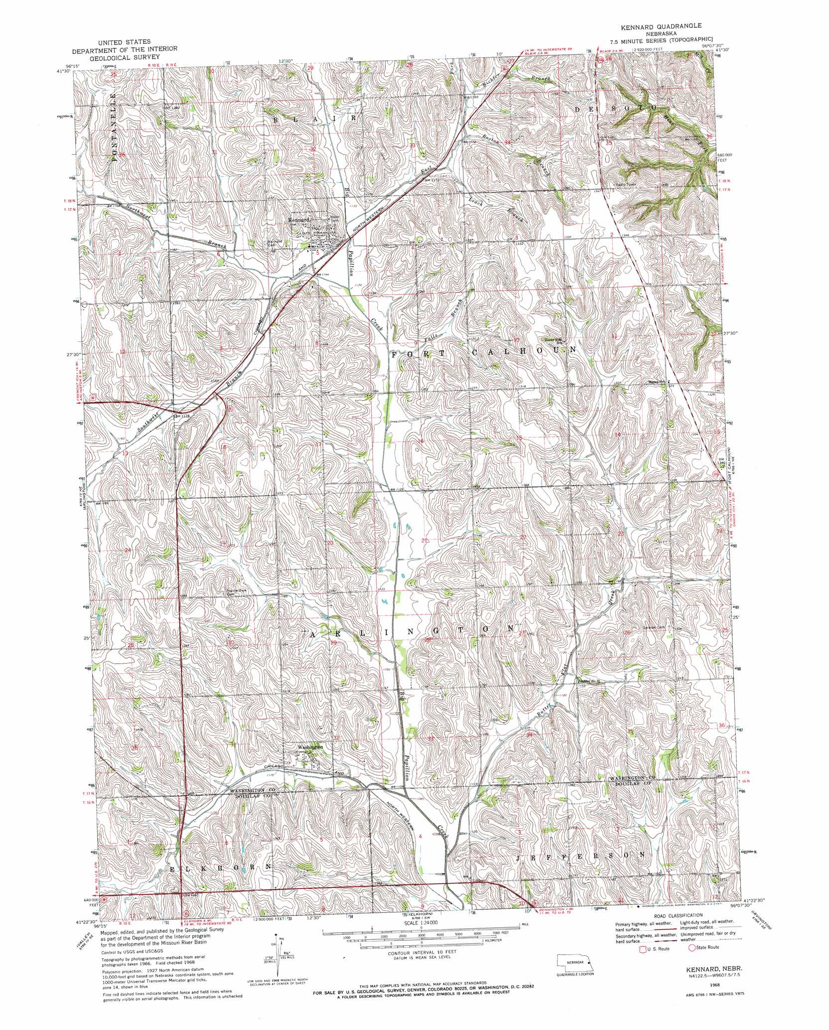
Kennard Topo Map Nebraska
To zoom in, hover over the map of Kennard
USGS Topo Quad 41096d2 - 1:24,000 scale
| Topo Map Name: | Kennard |
| USGS Topo Quad ID: | 41096d2 |
| Print Size: | ca. 21 1/4" wide x 27" high |
| Southeast Coordinates: | 41.375° N latitude / 96.125° W longitude |
| Map Center Coordinates: | 41.4375° N latitude / 96.1875° W longitude |
| U.S. State: | NE |
| Filename: | O41096D2.jpg |
| Download Map JPG Image: | Kennard topo map 1:24,000 scale |
| Map Type: | Topographic |
| Topo Series: | 7.5´ |
| Map Scale: | 1:24,000 |
| Source of Map Images: | United States Geological Survey (USGS) |
| Alternate Map Versions: |
Kennard NE 1968, updated 1971 Download PDF Buy paper map Kennard NE 2011 Download PDF Buy paper map Kennard NE 2014 Download PDF Buy paper map |
1:24,000 Topo Quads surrounding Kennard
Nickerson Nw |
Nickerson Ne |
Herman |
Mondamin |
Missouri Valley Nw |
Nickerson |
Orum |
Blair |
Modale |
Missouri Valley |
Fremont East |
Arlington |
Kennard |
Fort Calhoun |
Loveland |
Leshara |
Valley |
Elkhorn |
Irvington |
Omaha North |
Mead |
Wann |
Gretna |
Ralston |
Omaha South |
> Back to 41096a1 at 1:100,000 scale
> Back to 41096a1 at 1:250,000 scale
> Back to U.S. Topo Maps home
Kennard topo map: Gazetteer
Kennard: Dams
Papillion Creek Dam W-4 elevation 371m 1217′Kennard: Parks
Fort Atkinson Historical Marker elevation 346m 1135′Kennard: Populated Places
Kennard elevation 350m 1148′Washington elevation 350m 1148′
Kennard: Post Offices
Kennard Post Office elevation 350m 1148′Washington Post Office elevation 350m 1148′
Kennard: Reservoirs
Papillion Creek Reservoir W-4 elevation 371m 1217′Kennard: Streams
Boston Branch elevation 357m 1171′Butter Flat Creek elevation 329m 1079′
East Fork Big Papillion Creek elevation 348m 1141′
Falls Branch elevation 341m 1118′
Leach Branch elevation 352m 1154′
North Washington Creek elevation 345m 1131′
Northwest Branch Big Papillion Creek elevation 339m 1112′
Northwest Branch Papillion Creek elevation 339m 1112′
Richter Branch elevation 356m 1167′
South Washington Creek elevation 356m 1167′
Southwest Branch Big Papillion Creek elevation 346m 1135′
Washington Creek elevation 330m 1082′
Kennard digital topo map on disk
Buy this Kennard topo map showing relief, roads, GPS coordinates and other geographical features, as a high-resolution digital map file on DVD: