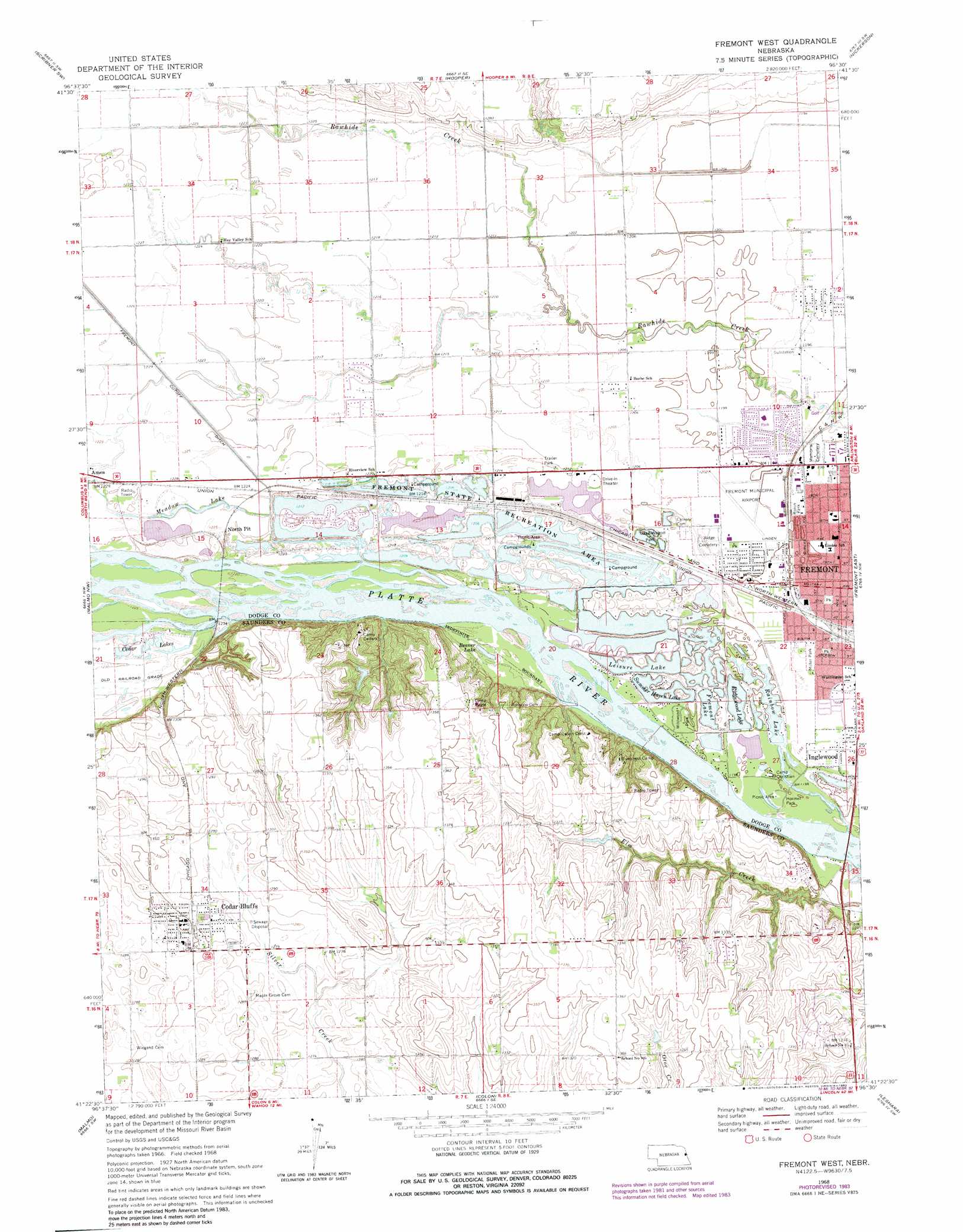
Fremont West Topo Map Nebraska
To zoom in, hover over the map of Fremont West
USGS Topo Quad 41096d5 - 1:24,000 scale
| Topo Map Name: | Fremont West |
| USGS Topo Quad ID: | 41096d5 |
| Print Size: | ca. 21 1/4" wide x 27" high |
| Southeast Coordinates: | 41.375° N latitude / 96.5° W longitude |
| Map Center Coordinates: | 41.4375° N latitude / 96.5625° W longitude |
| U.S. State: | NE |
| Filename: | O41096D5.jpg |
| Download Map JPG Image: | Fremont West topo map 1:24,000 scale |
| Map Type: | Topographic |
| Topo Series: | 7.5´ |
| Map Scale: | 1:24,000 |
| Source of Map Images: | United States Geological Survey (USGS) |
| Alternate Map Versions: |
Fremont West NE 1968, updated 1971 Download PDF Buy paper map Fremont West NE 1968, updated 1983 Download PDF Buy paper map Fremont West NE 2011 Download PDF Buy paper map Fremont West NE 2014 Download PDF Buy paper map |
1:24,000 Topo Quads surrounding Fremont West
Snyder |
Scribner |
Uehling |
Nickerson Nw |
Nickerson Ne |
Webster |
Scribner Sw |
Hooper |
Nickerson |
Orum |
North Bend |
Malmo Nw |
Fremont West |
Fremont East |
Arlington |
Prague |
Malmo |
Colon |
Leshara |
Valley |
Touhy |
Wahoo West |
Wahoo East |
Mead |
Wann |
> Back to 41096a1 at 1:100,000 scale
> Back to 41096a1 at 1:250,000 scale
> Back to U.S. Topo Maps home
Fremont West topo map: Gazetteer
Fremont West: Airports
Fremont Municipal Airport elevation 366m 1200′Fremont West: Bays
Bricks Bay elevation 367m 1204′Cottonwood Cove elevation 369m 1210′
Fremont West: Beaches
Fremont Beach elevation 369m 1210′Midland Beach elevation 371m 1217′
Fremont West: Capes
Fishermans Point elevation 367m 1204′Fremont West: Dams
Bouer Dam elevation 396m 1299′Camp Cedars B.S.A Earth Dam elevation 395m 1295′
Nenoname 2 Dam elevation 392m 1286′
Fremont West: Lakes
Beaver Lake elevation 369m 1210′Cedar Lakes elevation 373m 1223′
Fremont Lake elevation 365m 1197′
Leisure Lake elevation 366m 1200′
Meadow Lake elevation 372m 1220′
Rainbow Lake elevation 364m 1194′
Ridgewood Lake elevation 365m 1197′
Summer Haven Lake elevation 366m 1200′
Victory Lake elevation 367m 1204′
Fremont West: Parks
Christensen Field Agricultural Park elevation 367m 1204′Davenport Park elevation 367m 1204′
Freemont State Recreation Area elevation 370m 1213′
Great Platte River Route West Historical Marker elevation 370m 1213′
Hormel Park elevation 365m 1197′
Izaak Walton Park elevation 364m 1194′
Miller Park elevation 364m 1194′
Milliken Park elevation 364m 1194′
Pawnee Villages Historical Marker elevation 366m 1200′
Ronin Park elevation 366m 1200′
Wildwood Park elevation 366m 1200′
Fremont West: Populated Places
Ames elevation 374m 1227′Cedar Bluffs elevation 398m 1305′
Inglewood elevation 364m 1194′
Midway Trailer Court elevation 366m 1200′
South Broad Trailer Court elevation 364m 1194′
Westlake Mobile Home Park elevation 369m 1210′
Fremont West: Post Offices
Cedar Bluffs Post Office elevation 398m 1305′Fremont West: Reservoirs
Bouer Reservoir elevation 396m 1299′Camp Cedars Reservoir elevation 395m 1295′
Fremont West digital topo map on disk
Buy this Fremont West topo map showing relief, roads, GPS coordinates and other geographical features, as a high-resolution digital map file on DVD: