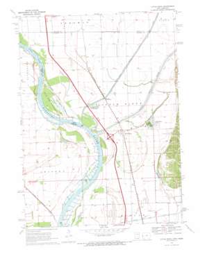
Little Sioux Topo Map Iowa
To zoom in, hover over the map of Little Sioux
USGS Topo Quad 41096g1 - 1:24,000 scale
| Topo Map Name: | Little Sioux |
| USGS Topo Quad ID: | 41096g1 |
| Print Size: | ca. 21 1/4" wide x 27" high |
| Southeast Coordinates: | 41.75° N latitude / 96° W longitude |
| Map Center Coordinates: | 41.8125° N latitude / 96.0625° W longitude |
| U.S. States: | IA, NE |
| Filename: | o41096g1.jpg |
| Download Map JPG Image: | Little Sioux topo map 1:24,000 scale |
| Map Type: | Topographic |
| Topo Series: | 7.5´ |
| Map Scale: | 1:24,000 |
| Source of Map Images: | United States Geological Survey (USGS) |
| Alternate Map Versions: |
Little Sioux IA 1970, updated 1972 Download PDF Buy paper map Little Sioux IA 2011 Download PDF Buy paper map Little Sioux IA 2013 Download PDF Buy paper map Little Sioux IA 2015 Download PDF Buy paper map |
1:24,000 Topo Quads surrounding Little Sioux
> Back to 41096e1 at 1:100,000 scale
> Back to 41096a1 at 1:250,000 scale
> Back to U.S. Topo Maps home
Little Sioux topo map: Gazetteer
Little Sioux: Bends
Little Sioux Bend elevation 309m 1013′Little Sioux Bend elevation 309m 1013′
Little Sioux: Canals
Crane Outlet elevation 313m 1026′McNeil Ditch elevation 314m 1030′
Soldier River Cutoff elevation 309m 1013′
Tekamah Ditch elevation 312m 1023′
Little Sioux: Crossings
Interchange 95 elevation 317m 1040′Little Sioux: Lakes
Smith Lake elevation 313m 1026′Little Sioux: Parks
Deer Island State Game Management Area elevation 313m 1026′Pelican Point State Recreation Area elevation 313m 1026′
Three Rivers Wildlife Area elevation 309m 1013′
Little Sioux: Populated Places
Little Sioux elevation 316m 1036′River Sioux elevation 317m 1040′
Little Sioux: Post Offices
Little Sioux Post Office elevation 316m 1036′River Sioux Post Office (historical) elevation 317m 1040′
Little Sioux: Streams
Little Sioux River elevation 310m 1017′Little Sioux digital topo map on disk
Buy this Little Sioux topo map showing relief, roads, GPS coordinates and other geographical features, as a high-resolution digital map file on DVD:


