Central City West Topo Map Nebraska
To zoom in, hover over the map of Central City West
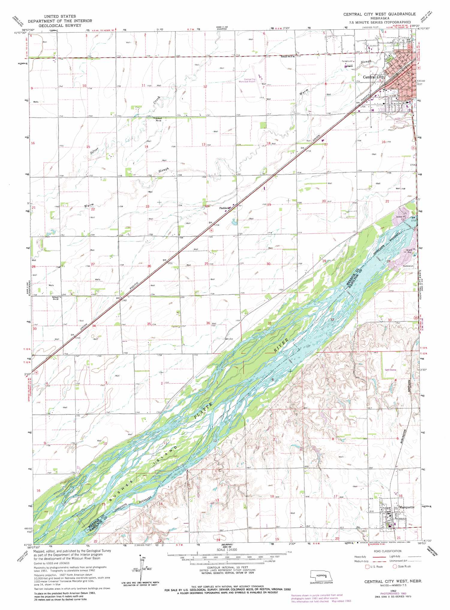
USGS Topo Quad 41098a1 - 1:24,000 scale
| Topo Map Name: | Central City West |
| USGS Topo Quad ID: | 41098a1 |
| Print Size: | ca. 21 1/4" wide x 27" high |
| Southeast Coordinates: | 41° N latitude / 98° W longitude |
| Map Center Coordinates: | 41.0625° N latitude / 98.0625° W longitude |
| U.S. State: | NE |
| Filename: | O41098A1.jpg |
| Download Map JPG Image: | Central City West topo map 1:24,000 scale |
| Map Type: | Topographic |
| Topo Series: | 7.5´ |
| Map Scale: | 1:24,000 |
| Source of Map Images: | United States Geological Survey (USGS) |
| Alternate Map Versions: |
Central City West NE 1962, updated 1963 Download PDF Buy paper map Central City West NE 1962, updated 1984 Download PDF Buy paper map Central City West NE 2011 Download PDF Buy paper map Central City West NE 2014 Download PDF Buy paper map |
1:24,000 Topo Quads surrounding Central City West
Cushing |
Belgrade Sw |
Belgrade Se |
Fullerton |
Havens |
Palmer |
Archer |
Hord |
Polk Nw |
Clarks |
Saint Lebory |
Chapman |
Central City West |
Central City East |
Polk |
Grand Island |
Phillips |
Murphy |
Hampton |
Henderson Ne |
Doniphan |
Giltner |
Aurora West |
Aurora East |
Henderson |
> Back to 41098a1 at 1:100,000 scale
> Back to 41098a1 at 1:250,000 scale
> Back to U.S. Topo Maps home
Central City West topo map: Gazetteer
Central City West: Airports
Central City Municipal Airport elevation 522m 1712′Central City West: Dams
Larsen Dam elevation 547m 1794′Tom Sherman Dam elevation 551m 1807′
Central City West: Islands
Bushes Island elevation 532m 1745′Central City West: Parks
Kernel Field elevation 518m 1699′Lone Tree Historical Marker elevation 518m 1699′
Lone Tree Park elevation 518m 1699′
North Park elevation 517m 1696′
Central City West: Populated Places
Central City elevation 518m 1699′Marquette elevation 554m 1817′
Paddock elevation 525m 1722′
Platte Valley Trailer Court elevation 518m 1699′
Central City West: Post Offices
Marquette Post Office elevation 554m 1817′Central City West: Reservoirs
Larsen Reservoir elevation 547m 1794′Sherman Reservoir elevation 551m 1807′
Central City West: Streams
Wood River elevation 535m 1755′Central City West digital topo map on disk
Buy this Central City West topo map showing relief, roads, GPS coordinates and other geographical features, as a high-resolution digital map file on DVD: