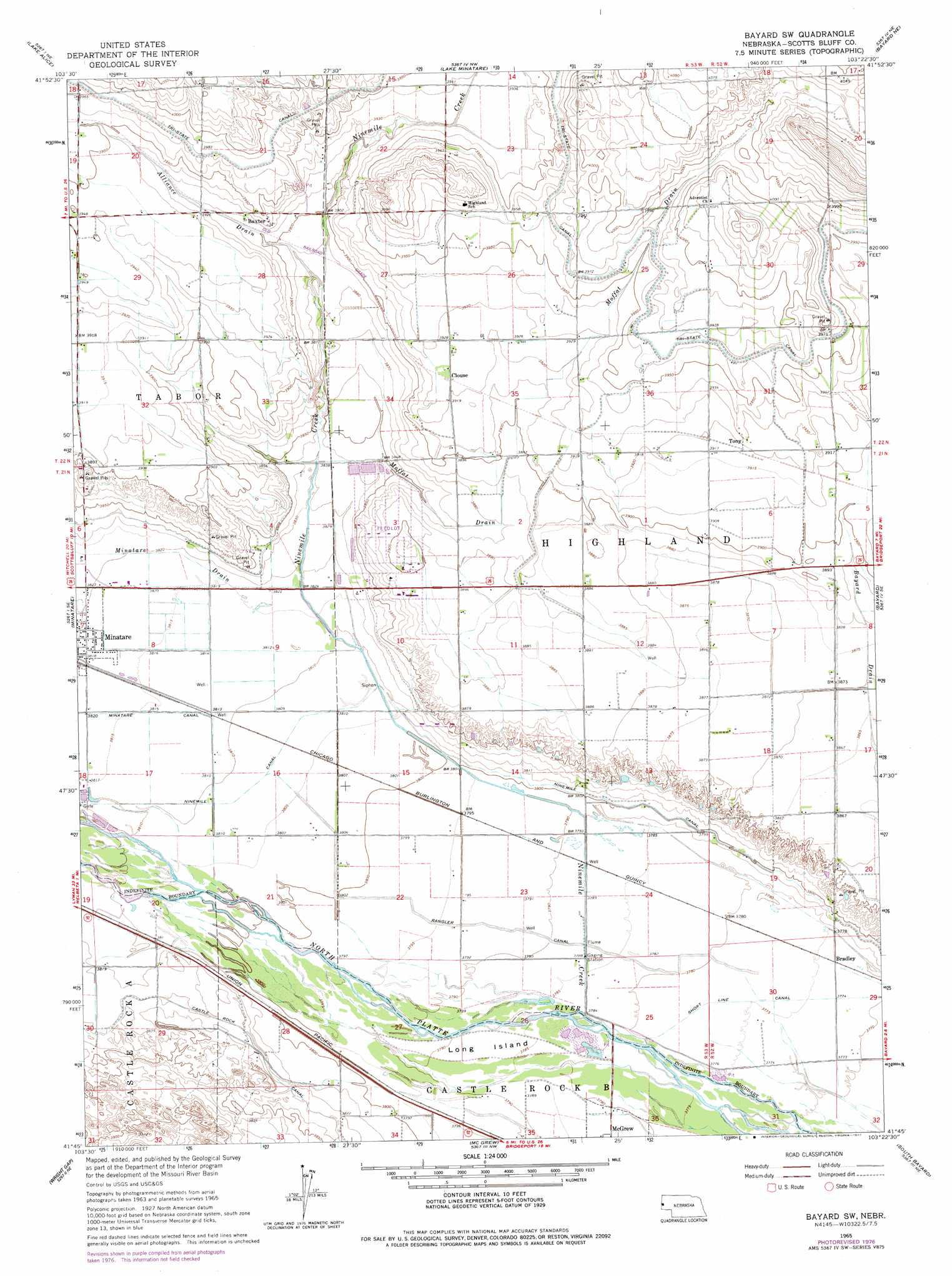
Bayard Sw Topo Map Nebraska
To zoom in, hover over the map of Bayard Sw
USGS Topo Quad 41103g4 - 1:24,000 scale
| Topo Map Name: | Bayard Sw |
| USGS Topo Quad ID: | 41103g4 |
| Print Size: | ca. 21 1/4" wide x 27" high |
| Southeast Coordinates: | 41.75° N latitude / 103.375° W longitude |
| Map Center Coordinates: | 41.8125° N latitude / 103.4375° W longitude |
| U.S. State: | NE |
| Filename: | O41103G4.jpg |
| Download Map JPG Image: | Bayard Sw topo map 1:24,000 scale |
| Map Type: | Topographic |
| Topo Series: | 7.5´ |
| Map Scale: | 1:24,000 |
| Source of Map Images: | United States Geological Survey (USGS) |
| Alternate Map Versions: |
Bayard SW NE 1965, updated 1967 Download PDF Buy paper map Bayard SW NE 1965, updated 1977 Download PDF Buy paper map Bayard SW NE 2011 Download PDF Buy paper map Bayard SW NE 2014 Download PDF Buy paper map |
1:24,000 Topo Quads surrounding Bayard Sw
University Lake |
University Lake Se |
Kilpatrick Lake Sw |
Kilpatrick Lake |
Hemingford 4 Sw |
Scottsbluff North |
Lake Alice |
Lake Minatare |
Bayard Ne |
Angora Nw |
Scottsbluff South |
Minatare |
Bayard Sw |
Bayard |
Angora |
Wildcat Mountain |
Wright Gap |
Mcgrew |
South Bayard |
Bridgeport Nw |
Harrisburg |
Indian Springs |
Hackberry Creek |
Redington |
Roundhouse Rock |
> Back to 41103e1 at 1:100,000 scale
> Back to 41102a1 at 1:250,000 scale
> Back to U.S. Topo Maps home
Bayard Sw topo map: Gazetteer
Bayard Sw: Canals
Castle Rock Canal elevation 1168m 3832′Minatare Canal elevation 1164m 3818′
Rangler Canal elevation 1156m 3792′
Bayard Sw: Channels
Ninemile Channel elevation 1159m 3802′Bayard Sw: Islands
Long Island elevation 1155m 3789′Bayard Sw: Populated Places
Baxter elevation 1204m 3950′Bradley elevation 1150m 3772′
Tony elevation 1195m 3920′
Bayard Sw: Post Offices
Baxter Post Office (historical) elevation 1204m 3950′Bayard Sw: Reservoirs
Bastron Lake elevation 1212m 3976′Bayard Sw: Streams
Alliance Drain elevation 1181m 3874′Bayard Drain elevation 1184m 3884′
Minatare Drain elevation 1165m 3822′
Moffat Drain elevation 1168m 3832′
Ninemile Creek elevation 1153m 3782′
Bayard Sw digital topo map on disk
Buy this Bayard Sw topo map showing relief, roads, GPS coordinates and other geographical features, as a high-resolution digital map file on DVD:
Eastern Wyoming & Western South Dakota
Buy digital topo maps: Eastern Wyoming & Western South Dakota