Petsch Reservoir Topo Map Wyoming
To zoom in, hover over the map of Petsch Reservoir
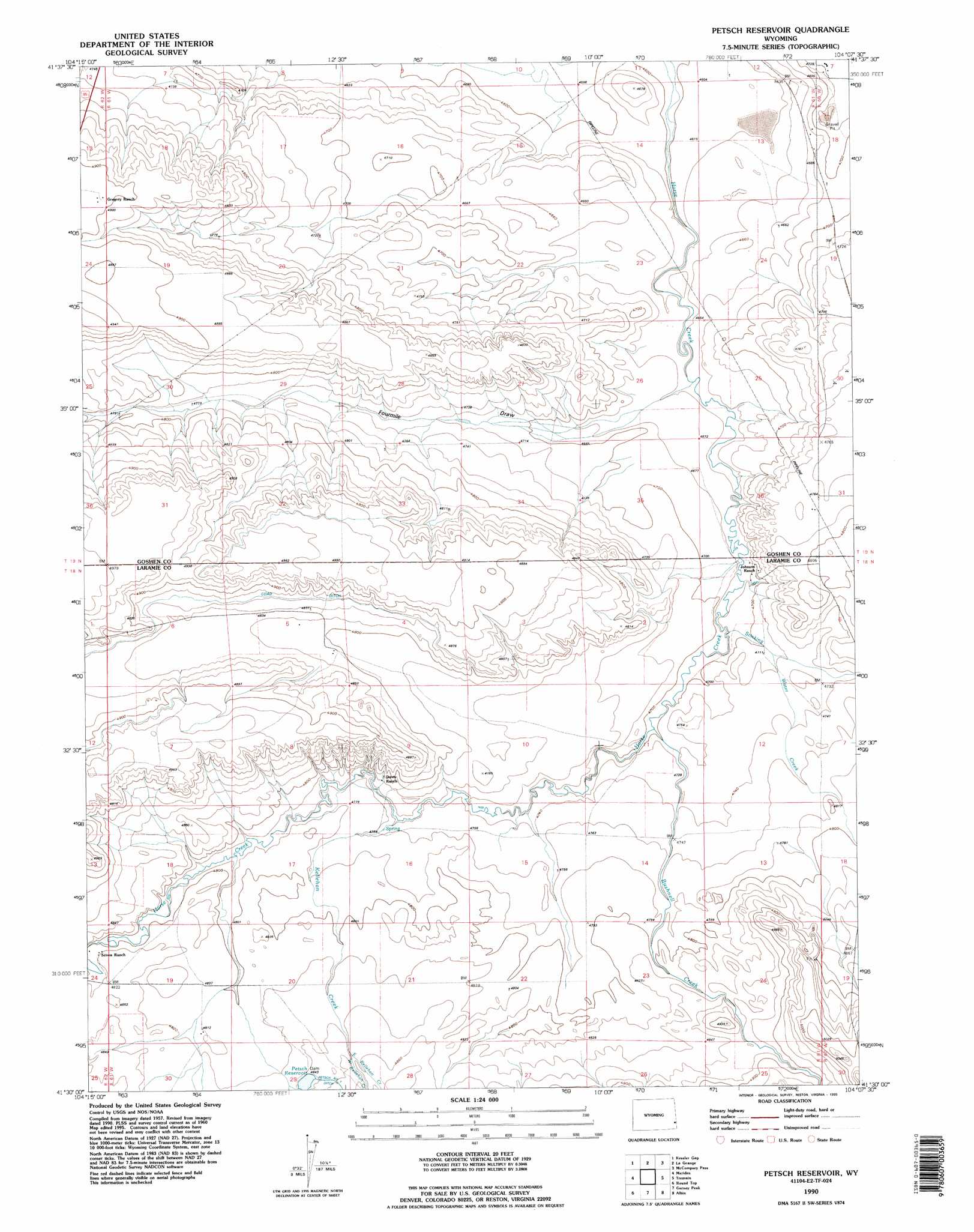
USGS Topo Quad 41104e2 - 1:24,000 scale
| Topo Map Name: | Petsch Reservoir |
| USGS Topo Quad ID: | 41104e2 |
| Print Size: | ca. 21 1/4" wide x 27" high |
| Southeast Coordinates: | 41.5° N latitude / 104.125° W longitude |
| Map Center Coordinates: | 41.5625° N latitude / 104.1875° W longitude |
| U.S. State: | WY |
| Filename: | o41104e2.jpg |
| Download Map JPG Image: | Petsch Reservoir topo map 1:24,000 scale |
| Map Type: | Topographic |
| Topo Series: | 7.5´ |
| Map Scale: | 1:24,000 |
| Source of Map Images: | United States Geological Survey (USGS) |
| Alternate Map Versions: |
Petsch Reservoir WY 1960, updated 1962 Download PDF Buy paper map Petsch Reservoir WY 1960, updated 1993 Download PDF Buy paper map Petsch Reservoir WY 1990, updated 1995 Download PDF Buy paper map Petsch Reservoir WY 2012 Download PDF Buy paper map Petsch Reservoir WY 2015 Download PDF Buy paper map |
1:24,000 Topo Quads surrounding Petsch Reservoir
Needle Rock |
Hawk Springs |
Duroc |
Robb Draw |
Stegall |
Diamond Flat |
Kessler Gap |
La Grange |
Mccompsey Pass |
Murray Lake |
Rocky Hollow |
Meriden |
Petsch Reservoir |
Tremain |
Murray Lake Sw |
Midway |
Round Top |
Gurney Peak |
Albin |
Kimball 2 Nw |
Midway Sw |
Midway Se |
Albin Sw |
Lindbergh |
Kimball 2 Sw |
> Back to 41104e1 at 1:100,000 scale
> Back to 41104a1 at 1:250,000 scale
> Back to U.S. Topo Maps home
Petsch Reservoir topo map: Gazetteer
Petsch Reservoir: Canals
Coad Ditch elevation 1484m 4868′Petsch Reservoir: Dams
Crown Number 2 Dam elevation 1412m 4632′Petsch Reservoir: Reservoirs
Crown Reservoir Number 2 elevation 1412m 4632′Petsch Reservoir elevation 1476m 4842′
Petsch Reservoir: Streams
Bushnell Creek elevation 1433m 4701′East Kellehan Creek elevation 1476m 4842′
Kellehan Creek elevation 1445m 4740′
Stinking Water Creek elevation 1427m 4681′
West Kellehan Creek elevation 1476m 4842′
Petsch Reservoir: Valleys
Fourmile Draw elevation 1427m 4681′Petsch Reservoir digital topo map on disk
Buy this Petsch Reservoir topo map showing relief, roads, GPS coordinates and other geographical features, as a high-resolution digital map file on DVD:
Eastern Wyoming & Western South Dakota
Buy digital topo maps: Eastern Wyoming & Western South Dakota