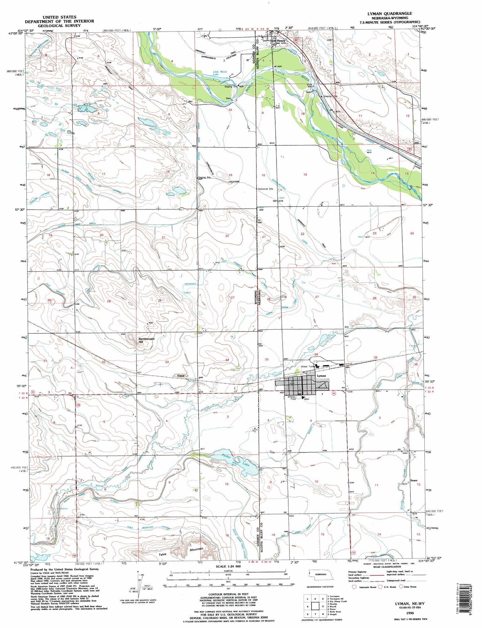
Lyman Topo Map Wyoming
To zoom in, hover over the map of Lyman
USGS Topo Quad 41104h1 - 1:24,000 scale
| Topo Map Name: | Lyman |
| USGS Topo Quad ID: | 41104h1 |
| Print Size: | ca. 21 1/4" wide x 27" high |
| Southeast Coordinates: | 41.875° N latitude / 104° W longitude |
| Map Center Coordinates: | 41.9375° N latitude / 104.0625° W longitude |
| U.S. States: | WY, NE |
| Filename: | o41104h1.jpg |
| Download Map JPG Image: | Lyman topo map 1:24,000 scale |
| Map Type: | Topographic |
| Topo Series: | 7.5´ |
| Map Scale: | 1:24,000 |
| Source of Map Images: | United States Geological Survey (USGS) |
| Alternate Map Versions: |
Lyman NE 1960, updated 1962 Download PDF Buy paper map Lyman NE 1960, updated 1974 Download PDF Buy paper map Lyman NE 1960, updated 1993 Download PDF Buy paper map Lyman NE 1990, updated 1995 Download PDF Buy paper map Lyman NE 2011 Download PDF Buy paper map Lyman NE 2014 Download PDF Buy paper map |
1:24,000 Topo Quads surrounding Lyman
Lingle |
Teakettle Rock |
Carpenter Ranch |
Chalk Buttes |
Chalk Buttes Ne |
Cottier |
Torrington |
Torrington Se |
Dry Sheep Creek |
Erdman Ranch |
Yoder |
Huntley |
Lyman |
Morrill |
Mitchell |
Hawk Springs |
Duroc |
Robb Draw |
Stegall |
Roubadeau Pass |
Kessler Gap |
La Grange |
Mccompsey Pass |
Murray Lake |
Murray Lake Ne |
> Back to 41104e1 at 1:100,000 scale
> Back to 41104a1 at 1:250,000 scale
> Back to U.S. Topo Maps home
Lyman topo map: Gazetteer
Lyman: Canals
Branch A elevation 1237m 4058′East Springer Lateral elevation 1279m 4196′
East Springer Lateral elevation 1278m 4192′
East Springer Main Lateral elevation 1251m 4104′
Farmers Canal elevation 1226m 4022′
Gering-Mitchell Canal elevation 1231m 4038′
Katzer Drain Branch elevation 1245m 4084′
McElhaney Drain elevation 1249m 4097′
North Horse Creek Lateral elevation 1250m 4101′
North Horse Creek Lateral elevation 1233m 4045′
Packer Ditch elevation 1248m 4094′
School Number 81 elevation 1227m 4025′
Lyman: Dams
Tri-State Diversion Dam elevation 1226m 4022′Lyman: Lakes
Little Moon Lake elevation 1229m 4032′Lyman: Parks
Horse Creek Treaty Historical Marker elevation 1232m 4041′Lyman: Populated Places
Henry elevation 1234m 4048′Lyman elevation 1234m 4048′
Sears elevation 1239m 4064′
Lyman: Post Offices
Henry Post Office (historical) elevation 1234m 4048′Lyman Post Office elevation 1234m 4048′
Lyman: Reservoirs
Packer Lake elevation 1242m 4074′Tri-State Diversion Reservoir elevation 1226m 4022′
Lyman: Ridges
Blue Bunch Ridge elevation 1235m 4051′Lyman: Streams
Centennial Creek elevation 1226m 4022′Kiowa Creek elevation 1232m 4041′
Owl Creek elevation 1226m 4022′
Lyman: Summits
Rattlesnake Hill elevation 1313m 4307′Table Mountain elevation 1319m 4327′
Lyman digital topo map on disk
Buy this Lyman topo map showing relief, roads, GPS coordinates and other geographical features, as a high-resolution digital map file on DVD:
Eastern Wyoming & Western South Dakota
Buy digital topo maps: Eastern Wyoming & Western South Dakota