Veteran Topo Map Wyoming
To zoom in, hover over the map of Veteran
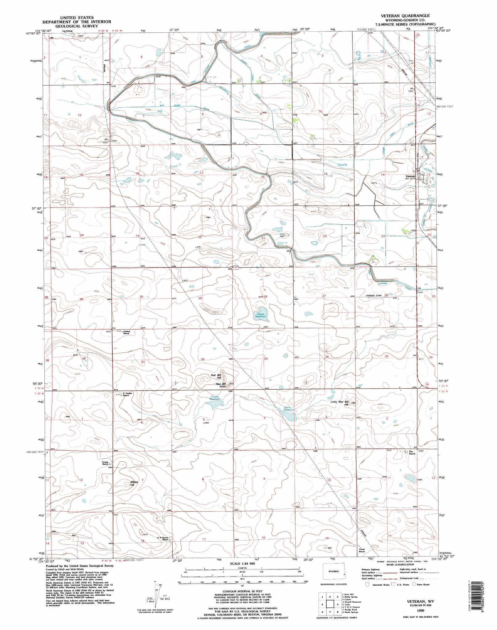
USGS Topo Quad 41104h4 - 1:24,000 scale
| Topo Map Name: | Veteran |
| USGS Topo Quad ID: | 41104h4 |
| Print Size: | ca. 21 1/4" wide x 27" high |
| Southeast Coordinates: | 41.875° N latitude / 104.375° W longitude |
| Map Center Coordinates: | 41.9375° N latitude / 104.4375° W longitude |
| U.S. State: | WY |
| Filename: | o41104h4.jpg |
| Download Map JPG Image: | Veteran topo map 1:24,000 scale |
| Map Type: | Topographic |
| Topo Series: | 7.5´ |
| Map Scale: | 1:24,000 |
| Source of Map Images: | United States Geological Survey (USGS) |
| Alternate Map Versions: |
Veteran WY 1960, updated 1962 Download PDF Buy paper map Veteran WY 1960, updated 1993 Download PDF Buy paper map Veteran WY 1990, updated 1995 Download PDF Buy paper map Veteran WY 2012 Download PDF Buy paper map Veteran WY 2015 Download PDF Buy paper map |
1:24,000 Topo Quads surrounding Veteran
Register Cliff |
Fort Laramie |
Barnes |
Lingle |
Teakettle Rock |
Eagles Nest |
Rock Eagle |
Habig Spring |
Cottier |
Torrington |
Dickinson Hill |
Glomill Reservoir |
Veteran |
Yoder |
Huntley |
Klutz Canyon |
Y B O Ranch |
Needle Rock |
Hawk Springs |
Duroc |
C S Ranch |
Cattail Ranch Ne |
Diamond Flat |
Kessler Gap |
La Grange |
> Back to 41104e1 at 1:100,000 scale
> Back to 41104a1 at 1:250,000 scale
> Back to U.S. Topo Maps home
Veteran topo map: Gazetteer
Veteran: Canals
Box Elder Drain elevation 1287m 4222′Myers Drain elevation 1291m 4235′
Veteran: Pillars
Red Bill Point elevation 1351m 4432′Veteran: Populated Places
Veteran elevation 1292m 4238′Veteran: Reservoirs
Eaton Reservoir elevation 1304m 4278′Likins Reservoir elevation 1323m 4340′
Yorges Reservoir elevation 1326m 4350′
Veteran: Summits
Little Red Bill Hill elevation 1337m 4386′Millies Hill elevation 1385m 4543′
Red Bill Hill elevation 1343m 4406′
Veteran digital topo map on disk
Buy this Veteran topo map showing relief, roads, GPS coordinates and other geographical features, as a high-resolution digital map file on DVD:
Eastern Wyoming & Western South Dakota
Buy digital topo maps: Eastern Wyoming & Western South Dakota