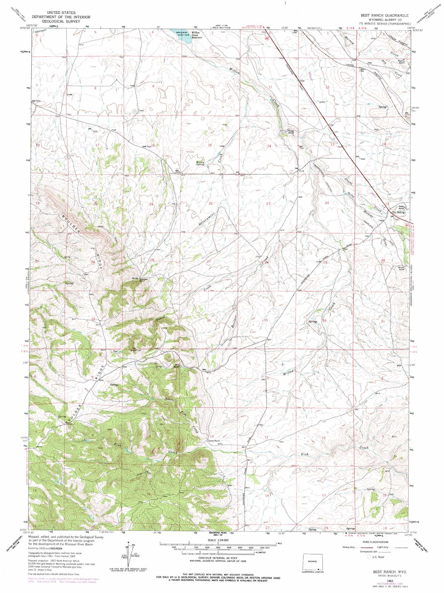
Best Ranch Topo Map Wyoming
To zoom in, hover over the map of Best Ranch
USGS Topo Quad 41105a5 - 1:24,000 scale
| Topo Map Name: | Best Ranch |
| USGS Topo Quad ID: | 41105a5 |
| Print Size: | ca. 21 1/4" wide x 27" high |
| Southeast Coordinates: | 41° N latitude / 105.5° W longitude |
| Map Center Coordinates: | 41.0625° N latitude / 105.5625° W longitude |
| U.S. State: | WY |
| Filename: | o41105a5.jpg |
| Download Map JPG Image: | Best Ranch topo map 1:24,000 scale |
| Map Type: | Topographic |
| Topo Series: | 7.5´ |
| Map Scale: | 1:24,000 |
| Source of Map Images: | United States Geological Survey (USGS) |
| Alternate Map Versions: |
Best Ranch WY 1963, updated 1965 Download PDF Buy paper map Best Ranch WY 1963, updated 1973 Download PDF Buy paper map Best Ranch WY 1963, updated 1978 Download PDF Buy paper map Best Ranch WY 2012 Download PDF Buy paper map Best Ranch WY 2015 Download PDF Buy paper map |
1:24,000 Topo Quads surrounding Best Ranch
La Marsh Creek West |
Laramie Sw |
Laramie |
Pilot Hill |
Green Top Mountain |
Caldwell Lake |
Hutton Lake |
Red Buttes |
Sherman Mountains West |
Sherman Mountains East |
Downey Lakes |
Johnson Ranch |
Best Ranch |
Dale Creek |
Buford |
Sand Creek Pass |
Eaton Reservoir |
Diamond Peak |
Cherokee Park |
Virginia Dale |
Deadman |
South Bald Mountain |
Red Feather Lakes |
Haystack Gulch |
Livermore Mountain |
> Back to 41105a1 at 1:100,000 scale
> Back to 41104a1 at 1:250,000 scale
> Back to U.S. Topo Maps home
Best Ranch topo map: Gazetteer
Best Ranch: Dams
Willow Creek Dam elevation 2272m 7454′Best Ranch: Mines
King Solomon Claim elevation 2471m 8106′Best Ranch: Populated Places
Tie Siding elevation 2346m 7696′Best Ranch: Reservoirs
Willow Creek Reservoir elevation 2272m 7454′Best Ranch: Ridges
Boulder Ridge elevation 2595m 8513′Best Ranch: Springs
Willow Spring elevation 2318m 7604′Best Ranch: Streams
Boulder Creek elevation 2348m 7703′Dry Creek elevation 2327m 7634′
Forest Creek elevation 2348m 7703′
Government Creek elevation 2270m 7447′
Grant Creek elevation 2298m 7539′
Little Fish Creek elevation 2455m 8054′
Best Ranch: Trails
Overland Trail elevation 2323m 7621′Best Ranch: Valleys
Dirty Woman Draw elevation 2309m 7575′Best Ranch digital topo map on disk
Buy this Best Ranch topo map showing relief, roads, GPS coordinates and other geographical features, as a high-resolution digital map file on DVD:
Eastern Wyoming & Western South Dakota
Buy digital topo maps: Eastern Wyoming & Western South Dakota