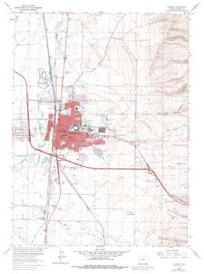
Laramie Topo Map Wyoming
To zoom in, hover over the map of Laramie
USGS Topo Quad 41105c5 - 1:24,000 scale
| Topo Map Name: | Laramie |
| USGS Topo Quad ID: | 41105c5 |
| Print Size: | ca. 21 1/4" wide x 27" high |
| Southeast Coordinates: | 41.25° N latitude / 105.5° W longitude |
| Map Center Coordinates: | 41.3125° N latitude / 105.5625° W longitude |
| U.S. State: | WY |
| Filename: | o41105c5.jpg |
| Download Map JPG Image: | Laramie topo map 1:24,000 scale |
| Map Type: | Topographic |
| Topo Series: | 7.5´ |
| Map Scale: | 1:24,000 |
| Source of Map Images: | United States Geological Survey (USGS) |
| Alternate Map Versions: |
Laramie WY 1963, updated 1964 Download PDF Buy paper map Laramie WY 1963, updated 1967 Download PDF Buy paper map Laramie WY 1963, updated 1978 Download PDF Buy paper map Laramie WY 2012 Download PDF Buy paper map Laramie WY 2015 Download PDF Buy paper map |
1:24,000 Topo Quads surrounding Laramie
> Back to 41105a1 at 1:100,000 scale
> Back to 41104a1 at 1:250,000 scale
> Back to U.S. Topo Maps home
Laramie topo map: Gazetteer
Laramie: Airports
Evans Airport elevation 2199m 7214′Laramie: Dams
Chris Klein Dam elevation 2215m 7267′Woodhouse Dam elevation 2218m 7276′
Laramie: Flats
Optimist Park elevation 2176m 7139′Undine Park elevation 2183m 7162′
Washington Park elevation 2195m 7201′
Laramie: Mines
Carroll Pit elevation 2204m 7230′Easterling Pit elevation 2184m 7165′
Justin Pit elevation 2270m 7447′
Kay Pit elevation 2215m 7267′
Sterling Limestone Quarry elevation 2278m 7473′
Laramie: Populated Places
Laramie elevation 2184m 7165′West Laramie elevation 2184m 7165′
Laramie: Reservoirs
Chris Klein Reservoir elevation 2215m 7267′Leah Reservoir elevation 2312m 7585′
Woodhouse Reservoir elevation 2218m 7276′
Laramie: Springs
City Springs elevation 2214m 7263′Pope Springs elevation 2240m 7349′
Laramie: Streams
Harney Creek elevation 2180m 7152′Soldier Creek elevation 2177m 7142′
Spring Creek elevation 2175m 7135′
Laramie: Valleys
Government Gulch elevation 2254m 7395′Government Gully elevation 2280m 7480′
Jack Rabbit Canyon elevation 2247m 7372′
Telephone Canyon elevation 2285m 7496′
Laramie digital topo map on disk
Buy this Laramie topo map showing relief, roads, GPS coordinates and other geographical features, as a high-resolution digital map file on DVD:
Eastern Wyoming & Western South Dakota
Buy digital topo maps: Eastern Wyoming & Western South Dakota


