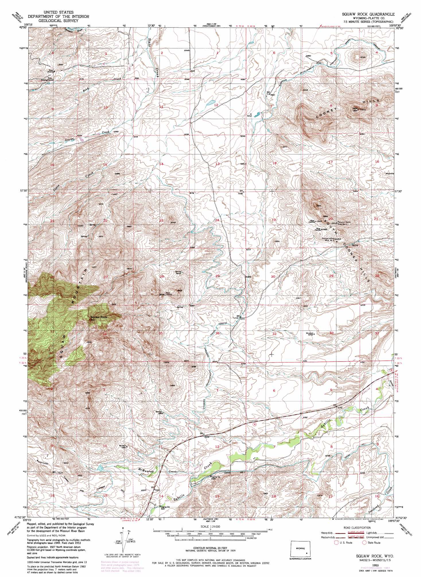
Squaw Rock Topo Map Wyoming
To zoom in, hover over the map of Squaw Rock
USGS Topo Quad 41105h2 - 1:24,000 scale
| Topo Map Name: | Squaw Rock |
| USGS Topo Quad ID: | 41105h2 |
| Print Size: | ca. 21 1/4" wide x 27" high |
| Southeast Coordinates: | 41.875° N latitude / 105.125° W longitude |
| Map Center Coordinates: | 41.9375° N latitude / 105.1875° W longitude |
| U.S. State: | WY |
| Filename: | o41105h2.jpg |
| Download Map JPG Image: | Squaw Rock topo map 1:24,000 scale |
| Map Type: | Topographic |
| Topo Series: | 7.5´ |
| Map Scale: | 1:24,000 |
| Source of Map Images: | United States Geological Survey (USGS) |
| Alternate Map Versions: |
Squaw Rock WY 1953, updated 1954 Download PDF Buy paper map Squaw Rock WY 1953, updated 1954 Download PDF Buy paper map Squaw Rock WY 1953, updated 1982 Download PDF Buy paper map Squaw Rock WY 2012 Download PDF Buy paper map Squaw Rock WY 2015 Download PDF Buy paper map |
1:24,000 Topo Quads surrounding Squaw Rock
South Mountain |
Fletcher Park |
Johnson Mountain |
Lewis Flat |
Dwyer |
Davidson Flats |
Reese Mountain |
Hightower Sw |
Hightower |
Wheatland |
Bull Camp Peak |
Moonshine Peak |
Squaw Rock |
Natwick |
Ferguson Corner |
Guide Rock |
Poe Mountain |
Natwick Sw |
Richeau Hills |
Double L Ranch |
Sheep Rock |
Indian Guide |
Delano Ranch |
Mcdonald Ranch |
Whitcomb Hill |
> Back to 41105e1 at 1:100,000 scale
> Back to 41104a1 at 1:250,000 scale
> Back to U.S. Topo Maps home
Squaw Rock topo map: Gazetteer
Squaw Rock: Canals
Wyoming Development Company Canal elevation 1631m 5351′Squaw Rock: Dams
Eshom Dam elevation 1527m 5009′Phelps Dam elevation 1641m 5383′
Phelps Number 2 Dam elevation 1671m 5482′
Squaw Rock: Mines
Big Mac Claim elevation 1583m 5193′Cooney Hill Prospect elevation 1696m 5564′
Friday Number Two Prospect elevation 1509m 4950′
JBC Deposit Mine elevation 1644m 5393′
McDougal Deposit elevation 1595m 5232′
Precious Honor Mine Number 1 elevation 1649m 5410′
Precious Honor Mine Number 2 elevation 1606m 5269′
Roff Deposit Mine elevation 1644m 5393′
Whipporwill Mine elevation 1699m 5574′
Squaw Rock: Reservoirs
Eshom Reservoir elevation 1527m 5009′Phelps Number 2 Reservoir elevation 1671m 5482′
Phelps Reservoir elevation 1641m 5383′
Squaw Rock: Ridges
South Cooney Hills elevation 1625m 5331′Squaw Rock: Streams
Deadhead Creek elevation 1542m 5059′George Creek elevation 1561m 5121′
McMurray Creek elevation 1588m 5209′
Reed Creek elevation 1516m 4973′
Squaw Rock: Summits
Squaw Mountain elevation 2085m 6840′Squaw Rock elevation 2085m 6840′
Squaw Rock digital topo map on disk
Buy this Squaw Rock topo map showing relief, roads, GPS coordinates and other geographical features, as a high-resolution digital map file on DVD:
Eastern Wyoming & Western South Dakota
Buy digital topo maps: Eastern Wyoming & Western South Dakota