Cow Creek Ranch Topo Map Wyoming
To zoom in, hover over the map of Cow Creek Ranch
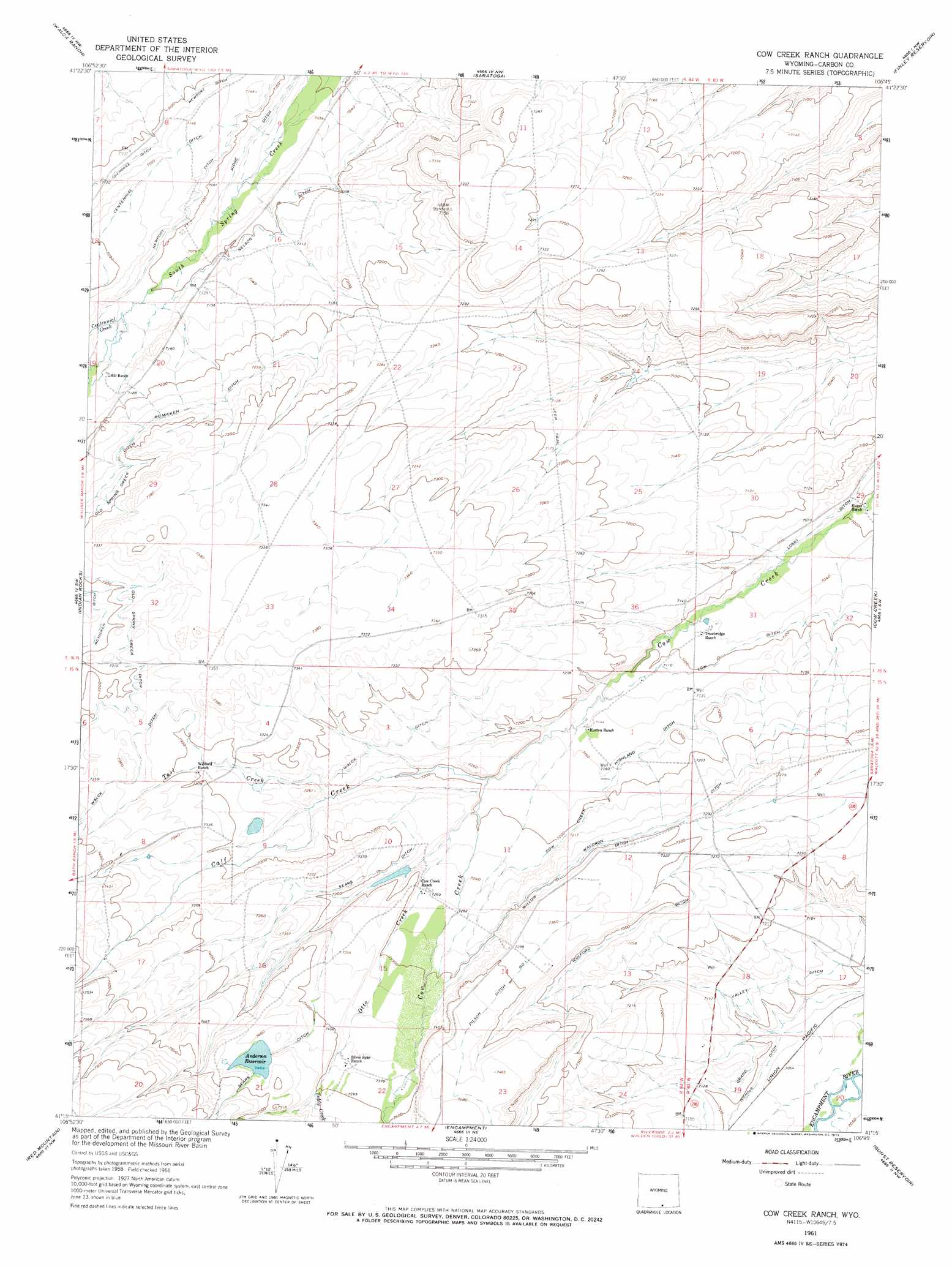
USGS Topo Quad 41106c7 - 1:24,000 scale
| Topo Map Name: | Cow Creek Ranch |
| USGS Topo Quad ID: | 41106c7 |
| Print Size: | ca. 21 1/4" wide x 27" high |
| Southeast Coordinates: | 41.25° N latitude / 106.75° W longitude |
| Map Center Coordinates: | 41.3125° N latitude / 106.8125° W longitude |
| U.S. State: | WY |
| Filename: | o41106c7.jpg |
| Download Map JPG Image: | Cow Creek Ranch topo map 1:24,000 scale |
| Map Type: | Topographic |
| Topo Series: | 7.5´ |
| Map Scale: | 1:24,000 |
| Source of Map Images: | United States Geological Survey (USGS) |
| Alternate Map Versions: |
Cow Creek Ranch WY 1961, updated 1963 Download PDF Buy paper map Cow Creek Ranch WY 1961, updated 1973 Download PDF Buy paper map Cow Creek Ranch WY 2012 Download PDF Buy paper map Cow Creek Ranch WY 2015 Download PDF Buy paper map |
1:24,000 Topo Quads surrounding Cow Creek Ranch
Kindt Reservoir |
Overland Crossing |
Overland |
Oberg Ranch |
Coad Mountain |
Jack Creek Reservoir |
Walck Ranch |
Saratoga |
Finley Reservoir |
Kennaday Peak |
Sharp Hill |
Indian Rocks |
Cow Creek Ranch |
Cow Creek |
Ryan Park |
Bridger Peak |
Red Mountain |
Encampment |
Gunst Reservoir |
Barcus Peak |
Fletcher Peak |
Solomon Creek |
Dudley Creek |
Blackhall Mountain |
Trent Creek |
> Back to 41106a1 at 1:100,000 scale
> Back to 41106a1 at 1:250,000 scale
> Back to U.S. Topo Maps home
Cow Creek Ranch topo map: Gazetteer
Cow Creek Ranch: Canals
Centennial Ditch elevation 2192m 7191′Cow Creek Highland Ditch elevation 2188m 7178′
Low Ditch elevation 2163m 7096′
Mcmicken Ditch elevation 2215m 7267′
Nelson Ditch elevation 2165m 7103′
Newport Ditch elevation 2174m 7132′
Old Spring Creek Ditch elevation 2230m 7316′
Ridge Ditch elevation 2155m 7070′
Walck Ditch elevation 2214m 7263′
Waldron Ditch elevation 2210m 7250′
Willow Ditch elevation 2225m 7299′
Wolford Ditch elevation 2222m 7290′
Cow Creek Ranch: Dams
Anderson Dam elevation 2275m 7463′Cow Creek Ranch: Reservoirs
Anderson Reservoir elevation 2276m 7467′Cow Creek Ranch: Streams
Calf Creek elevation 2190m 7185′Centennial Creek elevation 2171m 7122′
Otto Creek elevation 2195m 7201′
Tail Creek elevation 2204m 7230′
Teddy Creek elevation 2257m 7404′
Cow Creek Ranch digital topo map on disk
Buy this Cow Creek Ranch topo map showing relief, roads, GPS coordinates and other geographical features, as a high-resolution digital map file on DVD:
Eastern Wyoming & Western South Dakota
Buy digital topo maps: Eastern Wyoming & Western South Dakota